Section 2: Rosslare Harbour and Kilrane Settlement Plan
2.1 Historical Development
2.1.1 Kilrane
The older of the two settlements, historical maps from 1840 show a small group of buildings at Kilrane, including a school and a church, while maps from 1888-1913 show the addition of a post office and a forge. The settlement, which is now located on the N25, originally developed as a small settlement node. The primary school is located in Kilrane, along with two public houses and a small shop.
2.1.2 Rosslare Harbour
Following the completion of the railway line from Wexford to Rosslare Harbour in 1882 and the agreement in 1894 to allow passengers to dock at the harbour, a new settlement developed to accommodate the many employees of the expanding port. The village consisted of a social club, shop, handball alley, water reservoir, dormitory for overnighting locomotive crews, a water tower and other facilities. A new road, St Martin’s Road was constructed from Kilrane railway station through the new village. With the advent of the car ferries in the 1960s, this road was later extended to provide vehicular access to the pier.
2.2 Urban Structure and Character
While the plan area is comprised of two distinct places-Rosslare Harbour and Kilrane, they are mutually reliant on each other.
The settlement of Rosslare Harbour has a coarse/loose urban grain characterised by a low density, organic settlement pattern rather than a planned form. There are a mix of building types and plots of various widths, heights, sizes and configurations. The older part of the settlement is located along the cliff-top with a row of buildings addressing the sea with road access provided from the south. There is a walkway to the front of these buildings which provides a lovely local amenity and enjoys beautiful views across the sea. The provision of street furniture, including seating, has added to the attractiveness of this walkway for residents and visitors. The ‘Great Southern Hotel’, which has recently been demolished, formed a significant landmark in this area. There are a number of laneways which provide access to the cliff-top from St Martin’s Road. There are also ‘railway houses’ to the south of St Martin’s Road, arranged around the Railway Club and the Memorial Park.
The newest part of Rosslare Harbour developed to the southwest of the port. It is defined by a small number of mixed use developments arranged around a staggered crossroads on the N25. This area is home to a variety of uses including a Supervalu supermarket, pharmacy, café, fuel filling station, Church and bank.
Development has taken place in a somewhat uncoordinated manner so urban design opportunities have been missed in Rosslare Harbour, and this has contributed to a weak structure and sense of enclosure. The volume of HGV and car movements through the area also contributes to a poor sense of place, and contributes to a conflicted environment for the local residents.
In Kilrane the buildings are traditional in form and character and have a tighter urban grain. Significant suburban type residential development occurred to the south and east of the village during the 1990s and 2000s. These are cul-de-sac type developments characterised by semi-detached and detached dwellings.
2.3 Profile
2.3.1 Settlement Hierarchy
Rosslare Harbour and Kilrane is designated as a Level 3(a) Service Settlement in the Core Strategy Settlement Hierarchy. Level 3(a) settlements are important service settlements for their local communities and their wider rural hinterlands. Some of these settlements are important contributors to economic activity in the county including Rosslare Harbour and Kilrane which is home to Rosslare Europort. The settlement performs important functions including retail, commercial, education, residential, service and amenity functions. The Development Approach for these settlements is set out in the Core Strategy in Chapter 3 of Volume 1 Written Statement and is summarised here in Section 2.4.2.
2.3.2 Regional Status
Rosslare Europort is a key component of the economic and transport strategy that forms part of the RSES. The Europort forms part of a newly extended Eastern Economic Corridor (EEC) which extends from Belfast to Dublin to Rosslare Europort and includes the national road and rail links along the corridor and the settlements of Gorey, Enniscorthy, Wexford Town and Rosslare Harbour and Kilrane. This corridor in an important economic and transport opportunity, particularly in the post Brexit scenario. It also offers extended strategic connections throughout the island of Ireland through links with the TEN-T network.6
RPO 42 in the RSES supports the development of the EEC, strengthening economic links with the South-East by extending to Rosslare Europort, strengthening public transport connectivity and optimising the potential for rail freight.
The Europort is currently designated as a Tier 2 Port under National Ports Policy. The RSES supports the achievement of Tier 1 Status for the Europort with a supporting objective (RPO 142). This objective seeks to strengthen investment to deliver actions under National Port Policy and investment in sustainable infrastructure projects that:- Strengthen and develop the strategic international, national and regional economic role of Tier 1 and Tier 2 ports and support the strategic role of the ports and harbour assets under the National Marine Planning Framework,
- Support the export, fisheries, marine tourism and marine economy potential of the ports and support investment in the transition to smart technologies of ports and harbours.
The RSES further highlights the reciprocal relationship between the Key Town of Wexford Town and the Europort. The strategic location of Wexford Town in relation to the Europort is significant in the context of the EEC. The development of the Europort and access routes to the port will be of national strategic importance for the State, particularly post-Brexit. RPO 16 seeks to strengthen the role of Wexford Town as a strategic location, a self-sustaining regional economic driver and to leverage its strategic location and accessibility to Rosslare Europort. It also supports the development of industrial, commercial infrastructure and residential development in Wexford Town to support the port function at Rosslare Europort.
The development of road and rail links to Rosslare Europort is also seen as important enabler for the Key Towns of Carlow and Kilkenny, and the Waterford MASP.
2.3.3 Population
In 2016, 21% of the population were aged 65 and over. This is significantly higher than the county average of 14.7%. It can be attributed to the popularity of the area as a retirement location. The population amongst the remaining age cohorts are below the county’s averages.
2.3.4 Employment
Employment in Rosslare Harbour and Kilrane is dominated by the port-related, transport and logistics sectors. Local services including retail, bank, food and hospitality uses also provide local employment.
2.3.5 Existing Land Uses
There are a variety of land uses in the area. The village centre area in Rosslare Harbour is characterised by retail, hotel, leisure and residential uses. Transport and logistics companies are present with NVD car distribution centre and Roches Freight both located in Rosslare Harbour. Perennial Freight is currently located in Kilrane Enterprise Park, but has secured planning permission to relocate to Ballygerry in Rosslare Harbour. Other uses in the Enterprise Park include AES Waste Transfer Station and Castle Design Timber Ltd. Much of the remaining area of the two settlements is occupied by residential, community and education and open space uses.
2.3.6 Education
The local primary school is located in Kilrane. It had an enrolment of 329 pupils for the 2019/2020 school year. The school has been extended in recent years and has sufficient lands available to facilitate future extensions, if required.
There is no post primary school in the settlement and the Department of Education and Skills has not identified a need for one. Post primary education for local students is provided for in Bridgetown (c. 18km) and Wexford Town (c. 21km).
2.3.7 Infrastructure
There is a public wastewater treatment plant serving Rosslare Harbour and Kilrane. It has a capacity of 9,383 P.E. As of April 2020 the available headroom was 6,885 P.E which affords significant scope to develop its strategic economic role and fulfil its role in the Settlement Hierarchy.
The area is also served by public water from the Fardystown Regional Water Supply Scheme, and as of April 2020 it has capacity to accommodate new development.
2.3.8 Vacancy and Under-utilised Land
There are a number of vacant and/or under-utilised sites. This is prevalent in the Rosslare Harbour village centre area, in particular, the sites of the former Tuskar House Hotel and the Great Southern Hotel. The lands previously occupied by a large vehicle distribution centre on the N25 are currently used as the Border Inspection Post site for the Rosslare Europort. These lands which are owned by the OPW, and which extend to c. 7.3ha, offer significant development potential, albeit a section of the land is subject to flood risk.
2.3.9 Built and Natural Heritage
There are five protected structures in the plan area:
- WCC0513 St Ruane’s Church, Kilrane
- WCC0895 Farm House, Ballygillane Little, Rosslare Harbour
- WCC1380 Lighthouse Keepers’ House, Cliff Road, Rosslare Harbour
- WCC1381 Coastguard Station, Cliff Road, Rosslare Harbour
- WCC1382 Thatched house, Churchtown, Kilrane
There are two recorded monuments in the settlement plan area:
- WX048-016 Church Churchtown
- WX048-017 Castle Site Ballygerry
There are also newly identified archaeological sites which are scheduled for inclusion on the next Record of Monuments and Places. These are:
- WX048-017 17th century house, Ballygerry
- WX048-018 Windmill, Ballygerry
- WX048-154001 Ring ditch, Churchtown
- WX048-154002 Ring ditch, Churchtown
- WX048-154003 Ring ditch, Churchtown
- WX048-155 Excavation, Ballygerry
- WX048-156 Ring-ditch, Ballyaddragh
- WX048-016001 Church, Churchtown
- WX048-016002 Graveyard, Churchtown
The following designated sites (SACs and SPAs) are within 15km of the plan area:
- Site Code 002269 Carnsore Point SAC
- Site Code 000712 Wexford Slobs and Harbour SAC
- Site Code 004076 Wexford Slobs and Harbour SPA
- Site Code 002161 Long Bank SAC
- Site Code 000704 Lady’s Island SAC
- Site Code 004009 Lady’s Island SPA
- Site Code 004019 Raven SPA
- Site Code 000781 Slaney River Valley SAC
Proposed Natural Heritage Areas in the area include
- Site Code 000782 St. Helen’s Burrow, pNHA
- Site Code 000712 Wexford Slobs and Harbour pNHA
2.4 Development Strategy
2.4.1 Strategic Aim
“To create and sustain a vibrant settlement with a strong sense of place, an attractive public realm, a mix of uses and a high quality residential environment while maximising to the fullest potential the role of Rosslare Europort as a strategic national port to develop both port-related and other economic development and employment in the settlement and the county”.
2.4.2 Core Strategy Development Approach
As outlined in Section 2.3.1 Rosslare Harbour and Kilrane is designated as a Level 3(a) Settlement in the Core Strategy. The development approach for these settlements, which is set out in the Core Strategy, is summarised here:
- Focus on moderate population growth.
- Apply the sequential approach to the development of land, requiring residential development to take place within the existing footprint of the settlements. The leap frogging of infill/brownfield lands to undeveloped or greenfield lands will not be considered.
- Promote economic and enterprise development appropriate in scale to the settlements.
- Focus on the regeneration and renewal of these settlements.
- Ensure that new development contributes to the creation of attractive, liveable, well-designed, high quality settlements and that local communities enjoy a high quality of life and well-being.
- Support community organisations who are working to develop community facilities and promote and facilitate initiatives in the public realm.
- Protect and enhance amenities, heritage, green infrastructure and biodiversity in these settlements.
Having regard to the important economic and strategic role of Rosslare Harbour it has been allocated a 40% population growth for the period 2016-2040.
2.4.3 Settlement Structure and Development:
The plan aims to develop a strong and coherent settlement structure. This will be implemented through a Place concept, Route concept and Landscape concept which will enhance the existing structure.
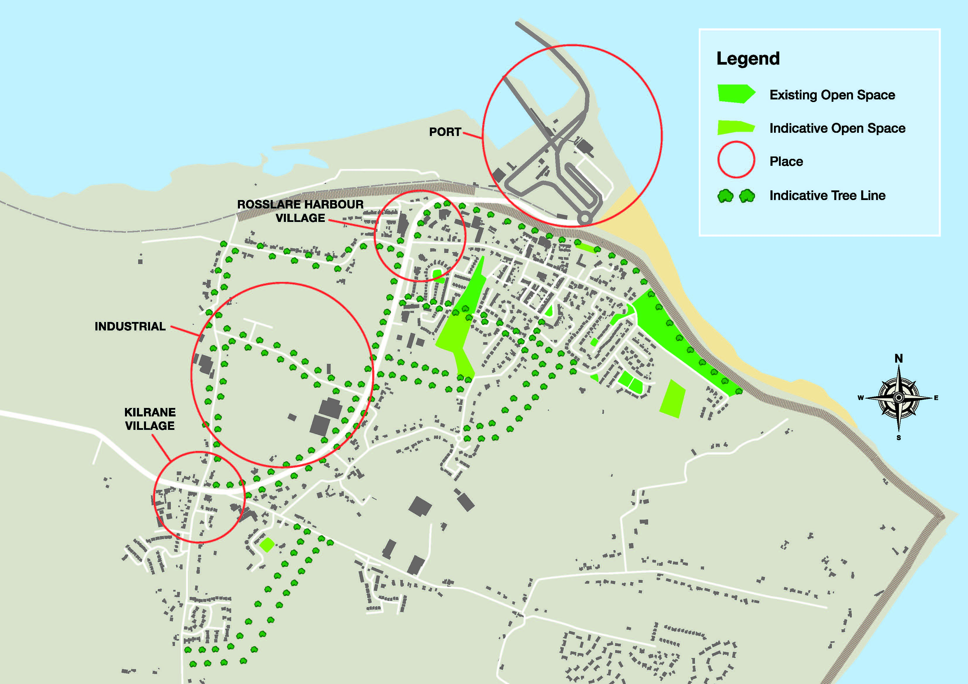
2.4.3.1 Place Concept
There are a number of distinct ‘places’ in the combined settlement. These can be enhanced by design and intervention. The key elements are:
- Rosslare Harbour village settlement centre.
- Kilrane village settlement centre.
- The Europort.
- The commercial lands which will facilitate the economic development of the port.
The proposals for the Place Concept are as follows (see Figure RHK-1):
Rosslare Harbour and Kilrane Settlements
- To consolidate the settlement centres as the focus for retail and services development.
- To improve the ‘place’ quality of these centres. The quality of architecture in these locations will be required to be high to create a sense of arrival to Ireland for people disembarking from the boat.
- To improve the public realm in these centres.
- To ensure development along Cliff Road provides a positive and strong aspect when viewed from the sea, and in this regard frontage should be provided on both the Cliff Road and St. Martin’s Road. Development should not back onto the coastal path (or any open space).
- To improve the legibility and strength of the edges in these centres to create a sense of enclosure in accordance with the urban design strategy below and Volume 1 Chapter 5 Design and Place-making in Towns and Villages.
The Europort:
To ensure that future development at the port:
- Results in an attractive place with an attractive public realm and where possible to ensure that the buildings are used to define the spaces.
- Uses its location beside the sea to take advantage of views for people waiting for the boat and other visitors to the port.
- Creates a high quality experience for people arriving in the country.
- Is accompanied by a public realm and landscape plan.
- Is cognisant of the natural heritage of the area.
The Commercial lands
- Require development to positively address the routes they front on to.
- Ensure, as far as possible, that storage, plant and equipment associated with port operations and associated fencing are located to the rear of the buildings/away from road frontages, preferably backing on to the rear of other commercial properties.
- Where buildings will not front onto the street to require a strong edge to be provided with street trees and ensure that these trees are consistent amongst developments.
Figure RHK-1 Place Concept and Landscape Concept
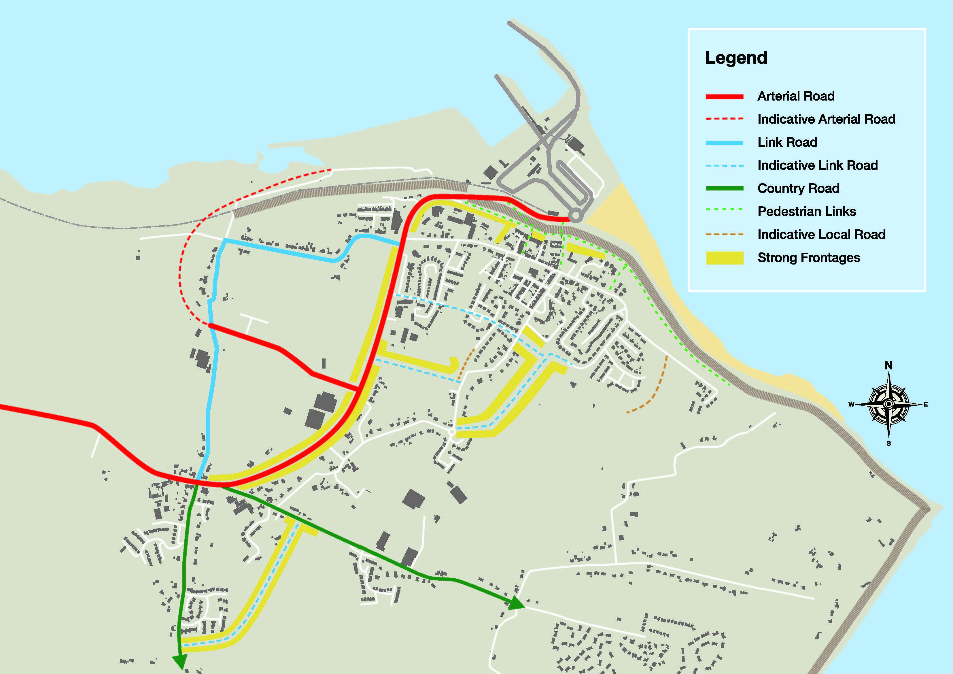
2.4.3.2 Route Concept
The existing route structure has a distinctive hierarchy:
- The Arterial route (spine) is the N25 which forms the main street/road from Kilrane through Rosslare Harbour and ending at Rosslare Europort.
- Link routes are the roads which link to the Arterial roads.
- Local routes are the routes which provide access within communities and to link Arterial and Link routes. These are roads and streets, and can serve individual developments, lanes and alleys e.g. St Martin’s Road, Cliff Road, Cawdor Street and Ballygillane Lane.
- Country routes are the routes which connect Kilrane to the south and to the east to St. Helen’s.
Severance is created in the settlement due to the main port access road running through the village centre. The existing route structure lacks permeability due to the number of housing estates which were developed individually and are comprised largely of cul-de-sacs. This is compounded by a lack of footpaths at key locations throughout the area. These factors have combined to result in a car-dominant environment.
The proposals for the Route concept are to:
- Ensure that the routes are designed in accordance with their designated status of Arterial, Link and Local (see Figure RHK-2, Section 5.9 of Volume 1 Chapter 5 Design and Place-making in Towns and Villages and Section 6 of Volume 2 Development Management Manual). Having regard to the prevailing building heights in the villages the buildings heights indicated for the route types in Volumes 1 and 2 will have to be moderated.
- Ensure that development along the route reflects the ‘movement’ function of the route and the ‘place’ function of the various ‘places’ through which it passes.
- Development in the settlement centres will require a higher quality treatment than where it passes through an industrial area.
- Ensure the route links identified in Section 2.4.9, Objective RHK27 and on Map 4 Objectives and Figure RHK-2 are delivered.
- Make retrospective links within the community in consultation with the residents of the settlement.
- Ensure that access is provided to backlands and that no development will prevent an opportunity to make a required link.
Figure RHK-2 Route Concept
2.4.3.3 Landscape Concept
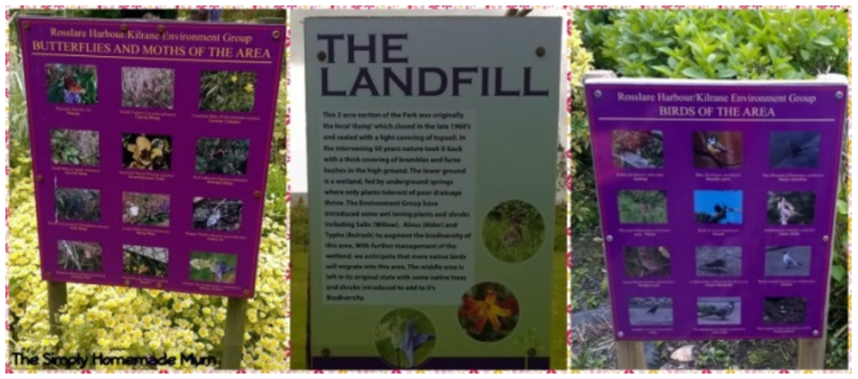 The main recreation and open space areas are located in Rosslare Harbour. A Memorial Park is located adjacent to the Railway Social Club on St Martin’s Road. The beautiful ‘Kirwan’s Garden’ is located to the southeast between La Rochelle and Tuskarmore Avenue housing developments. The garden is now maintained by the Rosslare Harbour/Kilrane Environment Group in collaboration with Tús, Solas and Kilrane/Rosslare Harbour Men’s Shed. It is a haven for biodiversity and makes a significant contribution to the area’s green infrastructure network. It also occupies 2 acres of land previously used as the local ‘dump’, and which closed in the late 1960s.
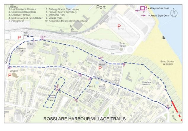
There is an established Wexford Walking Trail in Rosslare Harbour. It is a looped trail, approximately 2.9km long, taking in the cliff walk area and the previously mentioned Kirwan’s Garden. This trail and the cliff walk offer amenities to residents and visitors to the area.
Figure RHK-3 Route of the Wexford Walking Trail in Rosslare
There is a large playground facility located at St Brendan’s Estate, and Rosslare Rangers soccer fields are located to the south of St Brendan’s Estate.
The beach forms an important element in the landscape structure of the village being an amenity for active and passive recreation and an important area for biodiversity.
The landscape concept for the village is largely based on adding to the significant work of the residents to date. The proposals for the Landscape concept are (see Figure RHK-1):
- Provide a public realm scheme for the village which will provide a consistent treatment for landscaping and, in particular, street trees in the settlements to add to coherence.
- Provide for new public spaces on lands zoned for open space and amenity including a new Level 2 Neighbourhood Park in Kilrane and within developments in accordance with the standards set out in Volume 1 and Volume 2 of the CDP.
- Link the various elements that comprise the existing landscape structure, including the parks, beach and trail to allow for the dispersal of species and improve visual amenity.
- Provide upgraded parking and public realm at the beach.
2.4.4 Access for All and Age Friendly Development
As discussed in Section 2.3.3, 21% of the settlement’s population was over 65 years old in Census 2016. This is attributed to the attractiveness of the area as a place to retire to. The future planning of the settlements needs to carefully consider this and the needs of all users, including older people. The Planning Authority will assist developers and local community groups to ensure that this is achieved.
Access for All and Age Friendly Development Objective
It is the objective of the Council:
Objective RHK01
2.4.5 Urban Design and Public Realm Strategy
As discussed in Volume 1 Chapter 5 Design and Place-making in Towns and Villages, good urban design is a key component of compact growth and place making, ensuring that places are attractive to live, work and visit. In accordance with the Strategy outlined in Section 5.5 of Volume 1 Chapter 5 Design and Place-making in Towns and Villages, key place making objectives for the settlement plan area are to:
- Provide for quality in the design of buildings and places (Quality).
- Ensure that future urban development has a coherent urban structure, is permeable and places people at the heart of the design of streets and public realm (Connected).
- Ensure that future development is compact and rejuvenated (Compact).
- Ensure that development is vibrant, inclusive, resilient and adaptable.
Objective RHK02
Objective RHK03
Objective RHK04
Objective RHK05
Objective RHK06
Objective RHK07
Objective RHK08
Objective RHK09
Objective RHK10
2.4.6 Compact Growth
NSO 01 to deliver compact growth will be achieved by prioritising the village centre in Rosslare Harbour for future growth for residential and retail uses. This will focus on developing key infill, brownfield sites, under-utilised and vacant sites in the village centre, moving sequentially out from there to the remainder of the existing built-up footprint. This will ensure these sites are reused in the interests of sustainable development and that these sites or premises do not cause dis-amenity to their neighbours or the settlement.
For the purpose of the Urban Regeneration and Housing Act 2015 (as amended):
- The village centre between St Martin’s Road and Cliff Road has been identified as a Regeneration area (See Map 3 Land Use Zoning).
- All lands zoned Residential, or which include residential as open for consideration, are identified, .i.e. Village Centre, Neighbourhood Centre, Existing Residential and New Residential.
The sites of the former Great Southern Hotel and the Tuskar House Hotel are located within the defined Regeneration area. The Planning Authority will prioritise the development of these sites. These lands are zoned Village Centre and a variety of uses are open for consideration.
The Planning Authority will encourage the repurposing and reuse of existing vacant properties in the village centre for appropriate uses to contribute to regeneration and increasing the vibrancy of the plan area.
Density and building heights are two key components of compact growth. The density allocations for the settlement (see Section 2.4.8) will assist with delivery of compact growth, and the efficient use of land.
The Urban Development and Building Heights Guidelines outline that prevailing building heights have a critical role to play in addressing the delivery of more compact growth in our urban areas. The prevailing building height in the settlement plan area is two-storey with some three-storeys in the heart of Rosslare Harbour. The former Great Southern and Tuskar House Hotels were generally two-storeys in height (except for a section of the Great Southern which had basement storage/garages).
The Council has identified the following locations as appropriate for increased building heights:
- The sites of the former Great Southern Hotel and the former Tuskar Hotel.
- The Europort.
- Lands within Rosslare Harbour village centre.
- Industrial and commercial lands.
Buildings taller than the prevailing heights will be required to have a high quality design treatment and comply with the objectives of Volume 1 Chapter 5 Design and Place-making in Towns and Villages, Volume 2 Development Management Manual and the Urban Development and Building Heights - Guidelines for Planning Authorities (Department of Housing, Planning and Local Government, 2018).
Compact Growth Objectives
It is the objective of the Council:
Objective RHK11
Objective RHK12
Objective RHK13
- Adverse effects on existing amenities in such areas, in particular as a result of the ruinous or neglect condition of any land;
- Urban blight and decay;
- Anti-social behaviour; or
- A shortage of habitable houses or of land suitable for residential use or a mixture of residential and other uses.
Objective RHK14
Objective RHK15
Objective RHK16
Objective RHK17
2.4.7 Retail and Commercial Services
The area is well served by a range of retail and commercial services which includes supermarket, post office, bank, hairdressers, fuel station, cafés, restaurants and hotels. The Council will continue to facilitate the development of retail and commercial services that serve the local community, the rural hinterland and visitors and contribute to vibrant settlements. Such development will be located in accordance with the Land Use zoning and Volume 8 Retail Strategy.
Retail and Commercial Objectives
It is objective of the Council:
Objective RHK18
2.4.8 Residential
As set out in the Core Strategy, an additional population of 252 is allocated to Rosslare Harbour and Kilrane between 2021-2027. This equates to 172 additional households. At the allocated density of 25 units/ha this translates to 6.8ha of residential land. It is intended to deliver more than half of the new dwelling units on lands within the built-up footprint of the settlement plan area, achieving more than 30% envisaged by NPO 3c in the NPF.
A tiered approach to zoning has been applied in accordance with the NPF:
- Tier 1 lands are considered fully serviced/‘ready-to-go’, and are positioned within the existing built-up footprint.
- Tier 2 lands are not currently sufficiently serviced to support additional development but have the potential to become fully serviced during the lifetime of the plan.
The residential lands have been prioritised for development based on a number of factors including the planned levels of growth in the settlements, the achievement of compact growth, the application of the sequential approach, the location of the lands, availability of and proximity to amenities, schools, shops or employment, accessibility to transport services etc and the availability of infrastructure (either Tier 1 serviced land or Tier 2 serviceable land).
6.9ha of land are allocated to Phase 1 for delivery during the current plan period. In the event that some or none of these lands come forward for development during the first three years of the plan, i.e., three years from the date of the plan coming into effect, the lands in Phase 2 will be considered, in a sequential manner and subject to the infrastructural requirements being addressed.
As the Council must ensure that the Core Strategy figures are complied with and not exceeded, the Council will monitor the number of units granted on these residential zoned lands and the number of those units that have been either commenced or completed. This will be a material consideration in the assessment of subsequent planning applications and will inform the number of units that can be considered in subsequent planning applications (on either Phase 1 or Phase 2 lands).
Table RHK-1 provides the detail of the Parcel I.D, the lands in each phase, their tier, their size (ha), zoning, density, potential residential yield and infrastructural requirements and whether the parcel is within the existing built-up footprint. This table should be read in conjunction with Map 3 Land Use Zoning.
Proposals relating to the development of accommodation to meet the needs of older people, e.g. nursing homes, retirement villages and sheltered accommodation and the accommodation needs of people with disabilities will be considered on ‘Village Centre’ lands and ‘Existing/New Residential’ zoned lands.
Table RHK-1: Future Residential Development and Delivery Approach
| Parcel I.D |
Tier |
Phase | Within Existing Built Up Footprint |
Size (HA) |
Zoning |
Density |
Residential Yield7 |
Infrastructural Requirements |
| A |
1 |
1 |
Y |
1.72 |
Residential |
25/ha |
43 |
Fully serviced. Development to deliver a link road connecting St Brendan’s Estate to Ballygillane lane. Lands to be developed as blocks with frontage on all sides and provide for a link road to the adjoining Plot C lands to the southwest). |
| B |
2 |
1 |
Y |
2.25 |
Residential |
25/ha |
56 |
These lands are located to the west of the existing Barr na Haille housing development. Development to deliver a strong streetscape and frontage onto both sides of the required route through these lands. The development must also visually connect Barr na Haille to St Brendan’s Estate. |
| C | 2 | 2 | N |
4.0 |
Residential |
25/ha |
100 |
This land is located to the southwest of the Plot A lands. Its development is dependent on the footpath improvements along Ballygillane Lane and the Link route through the Plot A land which will continue to the roundabout at Ballyknockan Lands to be developed in blocks with strong frontages on both side of the link road. The site layout must provide an appropriately sized riparian buffer zone along the stream to address flood risk management and green infrastructure. |
| D |
2 |
2 | N |
1.4 |
Residential |
25/ha |
35 |
These lands are located to the east of Rosslare Rangers ground and to the south of the water tower. The development of these lands is dependent on the delivery of the local route through the adjoining Plot B lands to the north. |
| E(i) | 2 | 1 |
Y |
1.75 |
Residential |
25/ha |
44 |
These lands are located in Kilrane, on the L-7107 county road and to the south of Westwinds Housing Development. The development of this land is dependent on the provision of footpaths along the county road and will be required to deliver part of the new Link Road that will connect this county road with the L-7102. The development will be required to deliver a strong streetscape and frontage onto the L-7107 and on both sides of the required Link route. |
| E(ii) | 2 | 2 |
Y (circa 40% of the parcel area) |
1.0 | Residential | 25/ha | 25 | These lands are located to the south of Westwinds Housing Development and to the east of Parcel E(i). The development of these lands is dependent on the development of Parcel E(i). The development of this parcel will require the delivery of part of the new Link route from the L-7107 to the L-7102 and will require a strong streetscape and frontage onto both sides of the new Link route. |
| F | 2 | 1 |
Y (100% of the parcel area) |
1.2 | Residential | 25/ha | 30 | These lands are located on the Kilrane to St. Helen’s Road, approximately 60m east of Kilrane National School. Development to deliver a strong streetscape fronting onto St. Helen’s Road. |
Residential Objectives
It is the objective of the Council:
Objective RHK19
Objective RHK20
2.4.9 Transport and Movement
Local Improvements
Local improvements to footpaths, cycle ways and links between existing developments are required in order to improve permeability and encourage more sustainable trips by foot and bicycle. Section 2.4.3.2 provides details of the existing and proposed route structure in the Route concept which, together with the Place concept and Landscape concept informs the overall structure of the settlement. These local improvements are detailed on Map 4 Objectives and conceptually on Figure RHK-2.
National Roads
As outlined in Section 2.3, Rosslare Harbour and Kilrane is located on the EEC which is both a transport and economic corridor. The N25 and the Europort also form part of the wider TEN-T which provides strategic connections to the island of Ireland and mainland Europe. RPO 146 in the RSES aims to achieve high quality international connectivity through our ports and the strengthening and maintenance of access to ports through enhanced transport networks and improved journey times. Support for the M11 and the N80 improved connectivity to Rosslare Europort is highlighted.
Section 8.7.1.1 in Volume 1 Chapter 8 Transportation Strategy outlines the current position with the proposed N11/N25 Oilgate to Rosslare Harbour National Road Scheme. The advancement of this scheme is a priority for the future development of the Europort and the movement of passengers and freight and to help realise the potential of the EEC for the settlement plan area, the county and the region. Option selection work is being undertaken by consultants, which entails the identification and examination of scheme options, and the resulting design and environmental assessment processes. These processes are envisaged to be completed by 2023.
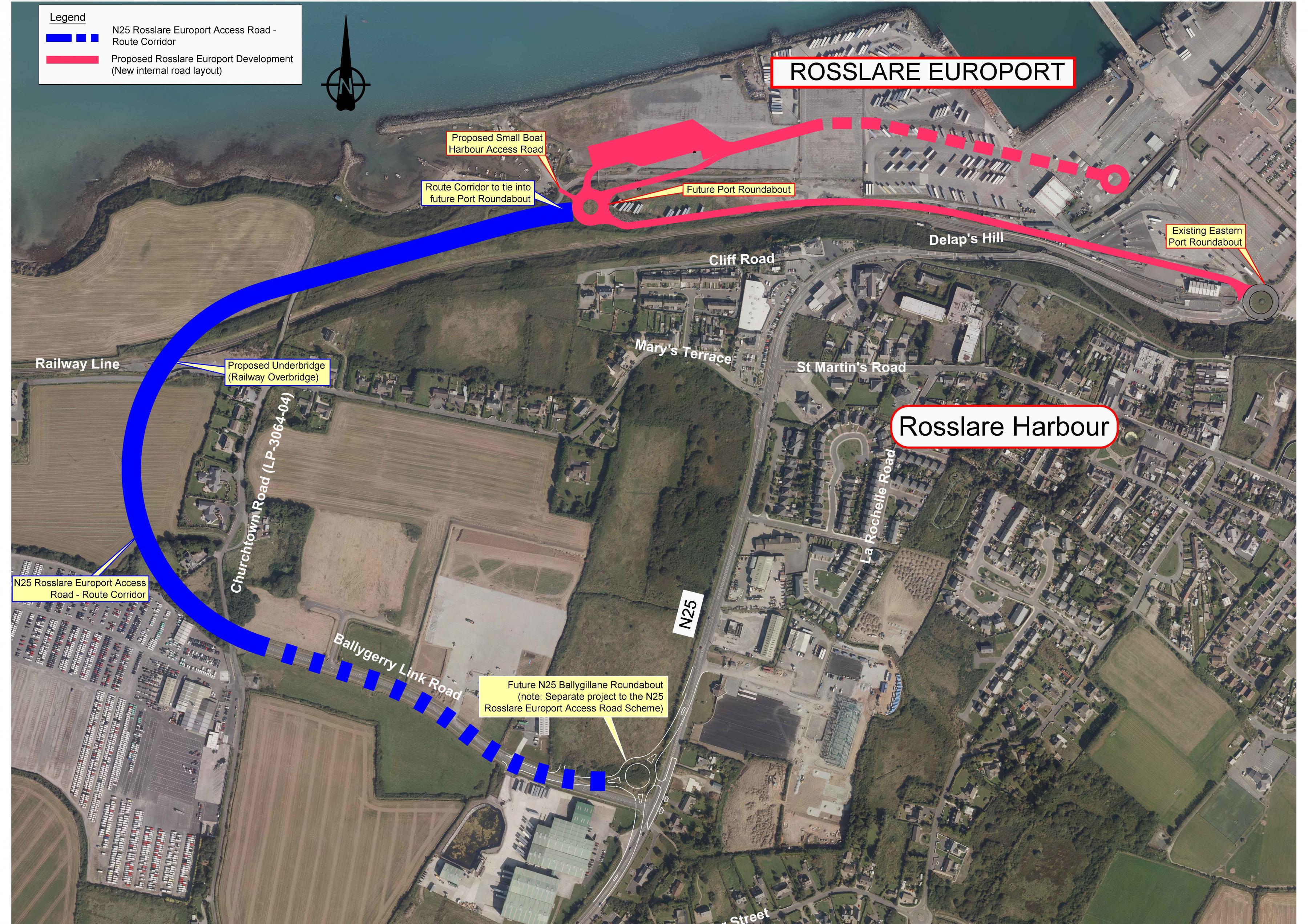
N25 Rosslare Europort Access Road
The proposed access road to Rosslare Europort is also discussed in Section 8.7.1.1 in Chapter 8 Transportation Strategy in Volume 1 Written Statement. Following the completion of Phase 2 (Option Selection), the Council confirmed the selected scheme option. The chosen option combines the construction of a new offline access road to the port, and the upgrade of the existing Ballygerry Link Road as shown in blue in Figure RHK-4.
The selected Scheme Option will now proceed to the next phase of the project, which is Design and Environmental Evaluation, during which it will be further developed to refine the design of the road alignment, junctions, accesses, and structures. The environmental evaluation of the scheme will be progressed in tandem with design development, with both elements of the process influencing each other.
Figure RHK-4 Selected Scheme Option for the N25 Rosslare Europort Access Road
In the interim and while the N25 remains a National Road, the Industry lands located to the north of and directly adjoining the N25 will be accessed from the local road to the east or from an access to the N25 that is located within the 60kph speed limit. Direct access to the Industry lands from the N25 where the 100kph zone applies will not be permitted, save for an exceptional circumstance provided for under Objective TS66 in Chapter 8 Transportation Strategy in Volume 1 Written Statement.
Rail
The TEN-T Network also includes rail lines and aims to achieve efficient, safe and seamless transport chains for passengers and freight. The Council will continue to advocate for the better integration of rail and ferry services for both passengers and freight. The RSES includes a RPO to prepare a Regional Freight Strategy (RPO 141) in consultation with a number of different bodies and agencies including local authorities.
The enhancement of public transport services, including rail services, is also important to facilitate more sustainable trips for both tourism related travel and travel by local residents and commuters.
Transport and Movement Objectives
It is the objective of the Council:
Objective RHK21
Objective RHK22
Objective RHK23
To require accessible footpaths to be delivered at the following locations (see Map 4 Objectives):
- From the school in Kilrane, along Ballygillane Lane to Cawdor Street
- From Kilrane north to Ballygerry and St. Mary's Estate.
- From Kilrane south to the cemetery.
- From Kilrane east to Kilrane Enterprise Park.
- From Kilrane to Rosslare Harbour along the N25.
Objective RHK24
Objective RHK25
Objective RHK26
Objective RHK27
To require new Link routes to be delivered at the following locations (see Map 4 and conceptually on Figure RHK-2):
- Between Ros Mór/La Rochelle and Portside
- From St Brendan’s Estate to the L-3059 through the Community and Education lands and Plot A New Residential land, and through the Community and Education lands and Plot C New Residential lands to the roundabout at Ballyknockan.
- Between Ballygillane Big and the N25.
- As part of the development of the Plot E(i), E(ii) and F lands to form part of an overall Link road connecting the L-7107 to the L-7102.
These link routes shall be designed in accordance with DMURS and the road category profiles set out in Volume 1 Chapter 5 Design and Place-making in Towns and Villages, Chapter 8 Transportation Strategy and Volume 2 Development Management Manual.
Objective RHK28
Objective RHK29
Objective RHK30
Objective RHK31
Objective RHK32
Objective RHK33
Objective RHK34
To support the development of new access routes to the Europort and to protect the preferred route, once this has been determined, and to prohibit development which would compromise the delivery of this link road.
Objective RHK35
To protect the existing N25 as a gateway entrance to Kilrane and Rosslare Harbour and to promote improvements to enhance the roadside landscape whilst maintaining the safe distribution of traffic through the villages to the Europort.
Objective RHK36
To promote investment in improved access infrastructure to Rosslare Europort, including the improvement of rail access.
Objective RHK37
2.4.10 Economic Development
The Europort
Rosslare Europort and port-related development offer significant scope to progress the economic development of the plan area, the county and the region. Post Brexit placement offers significant potential to the area. The RSES, through RPO 30, also recognises and supports the role of existing and potential inter-urban networks as regional significant drivers of collaboration and growth which includes the EEC which also provides strong connectivity to New Ross, the Waterford MASP and Belview Port.
As outlined in Volume 1 Chapter 6 Economic Development Strategy and Chapter 8 Transportation Strategy, the Southern Regional Assembly and the Council will continue to advocate for the designation of the Rosslare Europort as a Tier 1 Port under National Ports Policy and will continue to work Irish Rail, the owners of Europort, to achieve this status and maximise its full potential.
As the key port on the southern corridor of the Irish Sea the Europort serves a number of major shipping lines operating services between Rosslare and South Wales, and as the Irish port of choice on the Continental Direct Corridor it handles services between Rosslare and a variety of locations on the European mainland.
The Europort currently specialises in Roll on/Roll off (RORO) traffic, and is the second busiest Irish port for this type of traffic. The port handles approximately 130,000 road freight units a year, and it is estimated that up to 70% of freight coming into the Europort is carrying food or agricultural products. Up to 25,000 new cars come through the port for distribution to garages around the country. In addition, the level of business coming in to Rosslare is 50,000 tons of wood and 800,000 passengers every year.
The Europort offers a range of port services to meet both freight and passengers requirements including mooring, steverdoring, Tugmasters, piloting, lifting equipment, passenger handling and storage. The current infrastructure at the port includes four berths and Fisherman’s Quay, each with a gangway. There is storage available for 300 unaccompanied trailer spaces and up to 2,000 trade vehicles spaces. There is also storage available for logs and other Bulk Cargos on Fisherman's Quay.
The Europort is particularly well-placed to maximise opportunities for economic development. It can expand its shipping routes, and has the space to increase its freight and passenger handling business. However, investment is required in the Europort to realise this potential. The RSES highlights that significant investment in the port is required to accommodate larger RORO ships, improved capacity and facilities for freight handling (including rail freight) and improved amenities and services for passengers at the terminal. Investment in the Dublin-Gorey-Rosslare Europort rail line is also highlighted in order to protect the line and increase speed and frequency of services.
The RSES also highlights the need for continued development and improvement of ports by the relevant responsible commercial State-Owned Enterprises consistent with the sectoral policies defined through the National Ports Policy. It also highlights the need for continued support for Rosslare Europort (including the port’s Strategic Plan) and the need for a strategic review of Rosslare Europort.
Iarnród Éireann, as the Port Authority for Rosslare Europort, has recently secured planning permission for a major transformation of Rosslare Europort, as part of its Port Masterplan. The Masterplan will see significant investment in the infrastructure of the port and allow for expansion in the current key areas of RORO freight and passenger transport.
The Masterplan will also be providing the infrastructure necessary to facilitate the impending border inspection requirements while also creating increased capacity to capitalise on new business opportunities becoming available to the port. The Masterplan, together with initiatives under the strategic plan for the port, will see over €30 million invested by Iarnród Éireann in Rosslare Europort over a five-year period. It will ensure that Rosslare Europort will be equipped with the capacity, facilities and technology to facilitate major growth for the benefit of the region and the wider national economy. The major changes at Rosslare Europort will be:
- New configuration of the port aligned to maximise future growth of the port and support regional and national development.
- Significant new facilities and infrastructure to develop Rosslare Europort to its full potential as Ireland’s gateway port to both the United Kingdom and Continental Europe.
- Design and develop a Sustainable, Seamless and Smart Pot that will be best in class internationally.
Investment in the Europort will encourage and attract investment in port-related industries e.g. transport and logistics, manufacturing, industries that facilitate development in the marine area including energy, tourism and other types of spin-off businesses. Local businesses will also benefit from potential increase in passengers and freight. It is however important that future expansion and economic proposals safeguard the operation of the port, shipping routes and the maritime area as required under the National Marine Planning Framework. This is discussed further in Chapter 12 Coastal Zone Management and Marine Spatial Planning in Volume 1 Written Statement.
All development proposals will be subject to relevant environmental assessments, e.g. EIA AA and, where required, feasibility studies to establish that any expansion can be achieved without adverse effects on any European sites and within the carrying capacity of the receiving environment of ports.
Transport and Logistics
The transport and logistics industry is a significant feature of economic activity in the area, primarily related to freight and vehicle distribution. This is likely to expand as the Europort becomes busier following Brexit. The Council will continue to support the development of these industries on appropriately zoned land in the area.
The Blue Economy
Marine planning and marine developments offer significant opportunities for growth in new and existing industries in the area, and this in turn will bring socio-economic benefits including employment. The development of land-based infrastructure is critical to realising the economic and social benefits of marine activities, which only accrue when brought on land. Examples of this type of infrastructure include physical structures or facilities for landing, storage and processing of fish catches or freight, for passenger transfer or utilities transmission, slipways, and boat repair facilities.
Also, for certain developments and activities that are primarily land-based their associated marine infrastructure is critical to their effective operation. For example, a waste water treatment and disposal plant located at the coast requires a marine outfall pipe for the discharge of treated water.
The Council will support proposals for the development of land-based infrastructure in the area which facilitates marine activity and the diversification of marine industries. It also supports proposals for the development of marine infrastructure that facilitates land-based activity. As outlined in Volume 1 Chapter 12 Coastal Zone Management and Marine Spatial Planning, the Council will also continue to support the fisheries and seafood sector in the county, and provide for the expansion of landside facilities that provide for, and enhance the value added operations for this sector.
The Green Economy
Rosslare Harbour is well placed to take advantage of the opportunities offered by offshore renewable energy development such as offshore wind farms and tidal energy. This also offers land side opportunities to engage in energy related manufacturing, with the Europort providing the freight transport infrastructure. The Council will ensure that there is sufficient land zoned for industrial development to accommodate growth in this sector.
Tourism
As a coastal settlement on the attractive south coast of the county and home to Rosslare Europort, the settlement is well placed to maximise the benefits of tourism. The number of visitors who pass through the settlement going to/from the Europort offer significant opportunities to local businesses in the area, e.g. food, services, accommodation and in turn employment. There are also opportunities to expand cruise tourism at the Europort and maximise spin-offs for the local area, and the county.
The Council have been planning the development of a greenway on the rail line from Rosslare Harbour to Waterford City. However, the Government recently announced that the Wexford-Waterford rail link will be included in the upcoming all-island Strategic Rail Review and the Council has suspended the development project pending the outcome of this review. The optimal solution, which would achieve the aims of sustainable travel and tourism/economic development and amenity and health would be for a development which would allow for the development of the greenway alongside the existing track. Notwithstanding the Council would support such an approach subject to funding being made available by central government. In the interim the Council will support the development of a greenway from Rosslare Harbour to Rosslare Strand if this can be done in a manner which does not prejudice the operation or reopening of the lines.
As previously discussed, there is a need to improve the public realm and visual amenities of the settlement to encourage visitors to spend time there, and also to give a positive introduction to our county for those arriving at the Europort.
The Council will continue to support appropriate tourism related development which will expand the tourism profile of south Wexford. Proposals for tourism accommodation (e.g. holiday homes, short term letting and mobile home parks) will be carefully managed to ensure that the settlement retains a year-round resident population. There is one parcel of land zoned for tourism-related development (see Map 3 Land Use Zoning). Tourism related development will also be open for consideration on Village Centre lands.
Economic Development Zoned Lands
There is c.40ha of undeveloped industry land zoned in the settlement plan area. This is open to a variety of land uses including industry, manufacturing, transport and logistics and includes light industrial lands at Kilrane Business Park. This is in addition to the c.41ha of land zoned for port-related activity. This is considered sufficient to fulfil the economic development envisaged during the plan period. However, the Council will keep this under review.
Economic Development Objectives
It is the objective of the Council:
Objective RHK38
Objective RHK39
Objective RHK40
Objective RHK41
Objective RHK42
Objective RHK43
Objective RHK44
Objective RHK45
Objective RHK46
Objective RHK47
Objective RHK48
Objective RHK49
Objective RHK50
Objective RHK51
Objective RHK52
Objective RHK53
Objective RHK54
Objective RHK55
To support the development of a greenway from Rosslare Harbour to Rosslare Strand subject to this being achieved in a manner which does not prejudice the operation of existing or reopening of unused lines and subject to compliance with the Habitats Directive.
Objective RHK56
Objective RHK57
To examine the feasibility of reopening the disused Rosslare Europort to Waterford Railway as a sustainable transport corridor which would accommodate a reopened passenger and freight line and a greenway for active travel and amenity use. The Council will seek appropriate funding to facilitate the development of this important corridor between Rosslare Europort and Belview and Waterford MASP.
2.4.11 Recreation and Open Space
The provision of recreational facilities and amenities such as open spaces, public seating, footpaths, trails, playing fields, play areas and community halls can enhance well-being, encourage people to be active and promote safe community interaction and socialising. The village ‘green’/parks are important amenities in terms of their function as well as their visual appeal.
As previously mentioned, the existing recreation and open space facilities are all located in Rosslare Harbour. To this end, an area of land to the southwest of Kilrane National School/ Church Wood housing scheme is zoned open space and amenity. This location would be suitable for a Level 2 Neighbourhood Park (refer to Section 14.5 of Volume 1 for Hierarchy of Public Open Spaces).
Kirwan’s Garden is a wonderful example of the work local community groups do in the areas of green infrastructure and biodiversity. The local authority will continue to work with these groups to expand Kirwan’s Garden and the green infrastructure network in the settlement plan area and to expand recreation and open space provision in the area.
The Council will consider the expansion of existing and the development of new sporting facilities on appropriately zoned land in the settlement plan area.
Recreation and Open Space Objectives
It is the objective of the Council:
Objective RHK58
Objective RHK59
Objective RHK60
Objective RHK61
Objective RHK62
2.4.12 Community and Education
There is a small community centre in Kilrane. The Council would support the extension of that community centre or the development of a new community building an appropriate location so that it easily accessible by both settlements.
There is sufficient land zoned in the plan area for community and education to accommodate the development of community uses. There is also sufficient land in the vicinity of the local primary school to allow it expand in the future.
Community and Education Objective
It is the objective of the Council:
Objective RHK63
2.4.13 Flood Risk Management
A Stage 3 Flood Risk Assessment (FRA) was carried for this settlement as part of the County Strategic Flood Risk Assessment (SFRA). This involved the carrying out of detailed modelling and surveying of watercourses in and adjoining the settlement plan area (See Volume 11 for further details).
Flood risk was identified at the following locations (See Figure RHK-5):
-
The principle risk is from the small urbanised watercourses flowing through the settlement and the risk is related to culvert sizing and blockage.
- A small stream rises in Kilrane, predominantly fed by storm water runoff and flows in an easterly / south easterly direction towards St. Helens.
- A second stream rises in greenfield lands to the east of Rosslare Harbour and flows through Rosslare Harbour in a westerly direction, causing significant flooding to the former Rosslare Transport Centre lands where an undersized culvert causes ponding on the low lying land (now home to the Rosslare Europort Customs and zoned Port Related Activities - PRA). Upstream of this there are undeveloped Community and Education lands and New Residential lands, that are bordering the stream, but are not subject to significant out of bank flooding.
- A third stream rises to the south of the N25 to the west of Kilrane and flows in a northerly direction under the N25 where an undersized culvert causes flooding to farmland/farmyard. The watercourse continues in a northerly direction and joins the main Rosslare Harbour stream. These lands are zoned for Industry and Transport Infrastructure.
- Coastal flood risk at Rosslare Europort and the beach. However, the settlement is at low risk of tidal flooding due to the increase in elevation (most land circa 15-20m OD).
Flood Risk Management Approach
The Transport Infrastructure (TI) zoning, which relates to proposed route options to improve access to Rosslare Europort, traverses lands identified on the flood zone mapping as being within Flood Zone A and Flood B. The road is considered to constitute critical infrastructure and as such is a highly vulnerable use for the purposes of the Flood Risk Management Guidelines. The application and passing of the Development Plan Justification Test is required for highly vulnerable development in Flood Zone A and Flood Zone B. The zoning of these lands passed the Justification Test (see Appendix of the SFRA in Volume 11).
The SFRA outlines that the risk the Port Related Activities lands (the former Rosslare Transport Centre) can be accommodated by the application of the sequential approach at Development Management stage but this must be clearly demonstrated by an FRA following the guidance in Sections 4.4 to 4.11 of the SFRA.
The undeveloped Community and Education land upstream of the former transport centre that borders the Flood Zone should also be subject to an appropriately detailed FRA at the Development Management Stage in accordance with Sections 4.4 to 4.11 of the SFRA. This FRA should investigate the residual risk of culvert blockage if the intended use includes highly or less vulnerable development.
The New Residential lands upstream of the former transport centre has a watercourse flowing through it that remains in bank. Nevertheless, any proposed development should be subject to an appropriately detailed FRA at the Development Management Stage in accordance with Sections 4.4 to 4.11 of the SFRA and should investigate the residual risk of culvert blockage.
Further maintenance work/or re-culverting is recommended to assist in alleviating surface water flooding to the housing in Churchfields.
Elsewhere, any new development should follow the guidance provided in Sections 4.4 to 4.11 of the SFRA. In general, the sequential approach should be followed and Flood Zone A/B should be avoided for any highly or less vulnerable development. As with the other sites discussed above, particular attention should be paid to the residual risk of culvert blockage and this must be used to inform development.
The Planning Authority will require the provision of suitably sized riparian buffer zones along the New Residential (Plot C) lands, the Industry zoned lands to the west of the N25, Light Industry lands, Port-related activities land and Community and Education lands. The required buffer zones are shown as Open Space and Amenity on Map 3 Land Use Zoning and are subject to Objective RHK65.
The Council will continue to ensure that all future planning applications in the settlement plan area are screened for flood risk, that site-specific flood risk assessment are submitted where required and that the requirements of the County SFRA (Volume 11), the Flood Risk Management Guidelines and Chapter 9 Infrastructure Strategy (Volume 1), are fully complied with.
Figure RHK-5 Flood Zones Overlaid on Land Use Zoning Map
Flood Risk Management Objective
It is the objective of the Council:
Objective RHK64
Objective RHK65
To ensure riparian buffer zones are provided on the lands zoned Open Space and Amenity along watercourses in the plan area, and to require, where deemed necessary, that additional lands be set aside for riparian buffer zones. The width of the required riparian zones will be dependent on the width and characteristics of the watercourse and the nature of the site and will be determined having regard to the requirements of the ‘Planning for Watercourses in the Urban Environment (Inlands Fisheries Ireland 2020) and any updated version of these guidelines.
2.4.14 Coastal Erosion and Protection
The Council will continue to monitor coastal erosion in the settlement plan area, and carefully consider future applications in proximity to the coastline as set out in Chapter 12 Coastal Zone Management and Marine Spatial Planning in Volume 1 to ensure that the future development is not subject to coastal erosion risk, or increases coastal erosion elsewhere in the vicinity.
Coastal Erosion and Protection Objective
It is the objective of the Council:
Objective RHK66
Section 2.4.15 SEVESO Sites
As outlined in Chapter 10 Environment Management in Volume 1 Written Statement there is one SEVESO site within the Settlement Plan area. Roche’s Freight Warehousing is designated as an Upper Tier SEVESO site. The Planning Authority must consult the Health and Safety Authority’s regarding any planning applications received within a specified distance of this site (and any other future SEVESO sites that may be designated within the plan boundary). The planning consultation boundary for this site is identified on Map 4 Objectives. The Council will control development in the plan area in accordance with Objectives COMAH01 and COMAH02 in Chapter 10 and the requirements of the Health and Safety Authority.
2.5 Land Use Zoning and Matrix
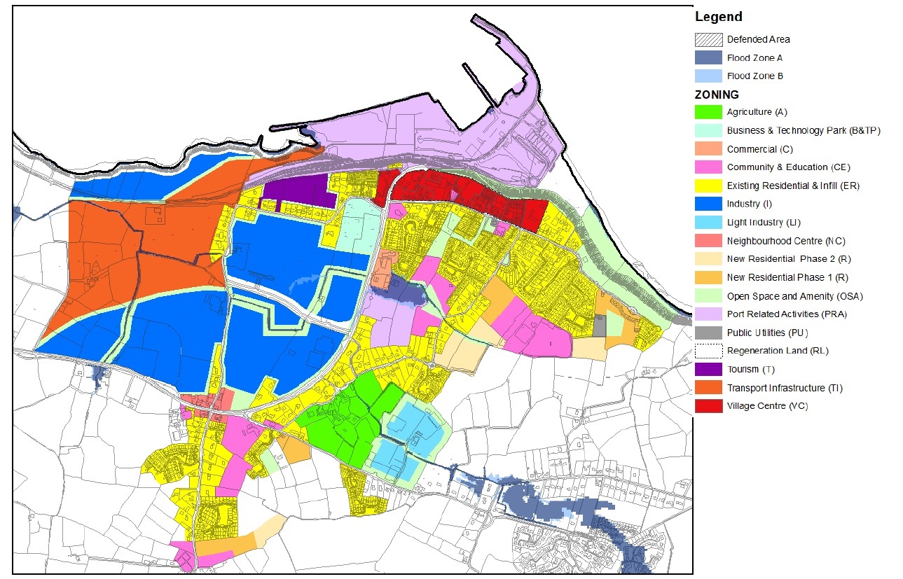
The purpose of land use zoning is to promote the orderly development of the settlement plan area, to establish an efficient basis for investment in public infrastructure and facilities and to avoid potential conflict between opposing land uses. It also identifies for property owners, developers and the public the types of developments and uses that the Planning Authority considers most appropriate on lands within the settlement plan area.
The land use zoning objectives, which are identified on Map 3 Land Use Zoning, have been formulated having regard to the following:
- The existing pattern of development.
- The need to promote the proper planning and sustainable development of Rosslare Harbour and Kilrane in accordance with national, regional and local policies.
- The need to zone sufficient lands at appropriate locations to accommodate the population allocation set out in the Core Strategy and to fulfil the strategic economic development role of Rosslare Europort.
- The protection of the environment and biodiversity and flood risk management.
- The location, accessibility and availability of land for development.
- The existing and future provision of essential infrastructure (water, sewerage and roads) and the need to ensure the efficient use of this infrastructure.
- The location and adequacy of existing social infrastructure (e.g. schools, childcare facilities and sport facilities).
- The character of the area with regard to the scale and pattern of development.
- The physical features and amenities of the area.
2.5.1 Land Use Zoning Objectives
Existing Residential (ER)
‘To protect and enhance the residential amenity of existing and developed communities’.
This zoning relates to existing residential lands. The purpose of this zoning is to preserve existing residential uses and to provide for infill residential development at a density that is considered suitable to the area. While infill or re-development proposals are acceptable in principle, careful consideration will be given to protecting residential amenities.
New Residential (NR)
‘To provide for new residential development, associated residential services and community services’.
The purpose of this zoning is to provide for new residential development within the existing built-up footprint of the settlement in a sequential manner in accordance with the tiered approach to development. The development of these lands will also deliver improvements to permeability in the Rosslare Harbour area through new local routes.
Village Centre (VC)
‘To provide for an attractive, vibrant village centre which maximises the use of lands and encourages a mix of residential, retail, commercial and civic uses’.
The purpose of this zoning is to enhance the vitality and viability of the village centre in Rosslare Harbour through the development of under-utilised and brownfield sites and by encouraging a mix of uses to make the village centre an attractive place to visit and live in.
Neighbourhood Centre (NC)
‘To provide for an attractive and vibrant centre in Kilrane’
This zoning relates to the area in Kilrane and is focused on the cross-roads. The purpose of this zoning is two-fold. Firstly, it defines the centre of this part of the settlement. Secondly, it provides for a mix of small scale retail services, a small element of infill residential and community development.
Community and Education (CE)
‘To protect, provide for and improve community, educational and ecclesiastical facilities’.
The purpose of this zoning is to protect and improve existing community, educational and institutional facilities and to safeguard their future provision. Residential uses will not normally be permitted, however this zoning does allow the following to be open for consideration - the development of accommodation for older people (e.g. nursing homes, retirement villages and sheltered accommodation) and the development of accommodation for people with disabilities (e.g. sheltered accommodation and residential care units) where it will be a community, approved voluntary body or public owned accommodation.
Open Space and Amenity (OSA)
“To provide for, protect and improve the provision, attractiveness, accessibility and amenity value of public open space and amenity areas”.
The objective of this zoning is to retain and protect exiting open spaces and to provide for new open spaces to meet the needs of all of the population. A strip of open space around the industrial areas will act as a physical break/transition between potentially conflicting land uses. The Planning Authority will not permit development that would result in a loss of established open spaces or lands zoned for recreation and amenity.
Business and Technology (BT)
‘To provide for business and technology related development’.
These lands are located to the west of the N25, south of Supervalu. The purpose of this zoning is to provide for business and technology related developments. The layout and design must deliver individual buildings of a high quality modern design with strong frontages onto the N25, surrounded by highly landscaped areas with car parking to be provided in screened areas to ensure minimum visual impact.
Light Industry (LI)
‘To provide for light industry and employment’.
This zoning relates to Kilrane Enterprise Park. The purpose of this zoning is to provide light industry and ancillary uses. Light industry is defined as any “industrial building in which the processes carried on or the plant and machinery installed are such as could be carried on or installed in any residential area without detriment to the amenity of that area by reason of noise, vibration, smell, fumes, smoke, soot, ash, dust or grit”.
Industry (I)
‘To provide for industry and employment’
These lands are located to the west of the N25 and can be accessed from the N25 via the Ballygerry Link Road and from the link road that runs north of Kilrane. The lands are also well positioned in close proximity to the N11-N25 Oilgate to Rosslare Harbour road scheme. The Industry zoning will provide for the needs of industry and transport users and it is envisaged that factories, manufacturing premises, ancillary warehouses, hauliers, logistics and marine related industrial developments will locate on these lands. This zoning provides for an open space buffer zone between these lands and the adjoining existing residential properties.
Port-related activities (PRA)
‘To provide for port-related activities’.
The purpose of this zoning is to provide for the needs of the port, industries/commercial activities with specific locational requirements at or in close proximity to the Europort. Passenger services including retail, restaurant and a public house as well as civic buildings related to the use of the Europort passenger terminal building will be open for consideration. This zoning also relates to the new Rosslare Europort Customs site located on the former NVD lands on the N25. The use on this site is directly related to the operation of Rosslare Europort.
Commercial (C)
‘To provide for a mix of commercial uses’
The purpose of this zoning is to provide for a range of commercial and other uses that do not take away from the village centre. These lands are located on the N25 to the north of the Rosslare Europort Custom’s site.
Tourism (T)
‘To provide for tourism related development’.
The purpose of this zoning is to provide for tourism related development, and any development on this site must not adversely affect the views or visual amenity of the area.
Transport Infrastructure (TI)
‘To provide for improved access to Rosslare Europort’
The purpose of this zoning is to provide for transportation infrastructure to facilitate improved access to Rosslare Europort.
Public Utilities (PU)
‘To provide for and improve public utilities’.
The purpose of this zoning is to protect and preserve land in the ownership of the local authority or other bodies charged with the provision of services such as electricity, telecommunications, water, waste or wastewater.
Agriculture (A)
‘To protect and/or restore agricultural lands’.
The purpose of this zoning is to protect existing agricultural operations and/or restore lands to agricultural use. Consideration will be given to the provision of a residential unit for occupation by the landowner or an immediate member of the landowner’s family where there is already an established residential use on these lands and the proposal would not conflict with the overall zoning objective.
2.5.2 Land Use Zoning Matrix
The land use zoning matrix is intended as a general guideline in assessing the acceptability or otherwise of developments proposed in each zone. This matrix is a guideline and the listed uses are not exhaustive. The indication that a use would be ‘permitted in principle’ or ‘open to consideration’ relates to the acceptability in principle of the use only. Factors such as density, height, traffic generation, environmental factors and design criteria are also of importance in establishing whether or not a development proposal conforms to the proper planning and sustainable development of an area (guidelines and standards on these matters are set out in Volume 1 Written Statement and Volume 2 Development Management Manual).
P = Permitted in Principle
A use which is ‘Permitted in Principle’ is generally acceptable subject to complying with the relevant policies, objectives, standards and requirements set out in the CDP.
O = Open for Consideration
An ‘Open for Consideration’ use is one which the Council may permit where it is satisfied that the suggested form of development will be compatible with the policies and objectives for the zone, will not conflict with the permitted uses and conforms with the proper planning and sustainable development of the area. Particular attention will be given to the nature and scale of the development when assessing compatibility. When considering whether any given development is appropriate in any zone, the Planning Authority will have regard to the objectives of the relevant chapter/strategy in the CDP.
N= Not Permitted
Development listed as ‘Not Permitted’ in a particular zone will not be permitted for one or more of the following reasons:
- it may have an undesirable effect on existing and permitted uses,
- it may be incompatible with the objectives for the settlement or
- it may be inconsistent with the proper planning and sustainable development of the area.
Change of Use and Extensions of Existing Buildings
Change of use and extensions to existing buildings will generally be required to be consistent with the zoning matrix. Exceptions to uses not normally permissible in the zoning matrix will be considered where:
- the Planning Authority is satisfied that the use or extension would not conflict with the land use zoning
- the use or extension would not negatively impact on the amenity of the area
- the use or extension would not give rise to additional planning considerations above those for the existing/previous use.
LAND USE ZONING MATRIX
N not normally acceptable, O open for consideration, P permitted in principle|
USES |
ER1 |
NR1 |
VC |
NC | CE | OSA | BT |
LI1 |
I1 |
PRA1 |
C |
T |
PU |
A |
TI |
|
Agricultural Merchants |
N |
N |
O | N | N | N | N |
O1 |
N |
N |
O |
N |
N |
N |
N |
|
Allotments |
O1 |
O1,3 |
O | O | O | O1 | N |
N |
N |
N |
N |
N |
N |
O1 |
N |
|
Financial institutions/ facilities |
N | N | P | O | N | N | O |
N |
N |
O1 |
O1 |
N |
N |
N |
N |
|
Betting office |
N |
N |
O |
N |
N |
N |
N |
N |
N |
N |
N |
N |
N |
N |
N |
|
Car park |
O 1,2 |
O1,3 |
P |
O |
O2 |
O2 |
O2 |
O1 |
O1 |
O1 |
O |
O2 |
N |
N |
N |
|
Caravan Park |
N |
N |
N |
N |
N |
N |
N |
N |
N |
N |
N |
N |
N |
N |
N |
|
Childcare facilities crèche/nursery |
O1 |
O1,3 |
P |
P |
P |
N |
O |
N |
N |
O1 |
O |
N |
N |
N |
N |
|
Civic amenity/ recycling centre |
O1 |
O1,3 |
P |
O |
O |
O |
O |
O1 |
P1 |
O1 |
O |
N |
O |
N |
N |
|
Civic buildings |
O1 |
O1,3 |
P |
P |
P |
O2 |
O |
N |
N |
O1 |
O1 |
O |
N |
N |
N |
|
Culture, recreation & leisure |
O1 |
O1,3 |
P |
P |
P |
O2 |
O |
N |
N |
O1 |
O |
O |
N |
N |
N |
|
Education |
O1 |
O1,3 |
P |
O |
P |
N |
O |
N |
N |
N |
O |
N |
N |
N |
N |
|
Enterprise centre |
N |
N |
P |
O |
N |
N |
P |
O1 | O1 | O1 |
P |
N |
N |
N |
N |
|
Garden centre |
N |
N |
O |
O |
N |
N |
O |
N |
N |
N |
O |
N |
N |
N |
N |
|
Industry (general) |
N |
N |
N |
N |
N |
N |
O |
N |
P1 |
O1 |
N |
N |
N |
N |
N |
|
Industry (light) |
N |
N |
N |
N |
N |
N |
P |
P1 |
O1 | O1 |
O |
N |
N |
N |
N |
|
Hotel |
N |
N |
P |
O |
N |
N |
N |
N |
N |
N |
O |
N |
N |
N |
N |
|
Hostel |
N |
N |
P |
N |
N |
N |
N |
N |
N |
N |
O |
N |
N |
N |
N |
|
Medical and related consultants |
O1 |
O1,3 |
P |
O |
O |
N |
O |
N |
N |
N |
O |
N |
N |
N |
N |
|
Motor sales showroom |
N |
N |
N |
N |
N |
N |
N |
N |
N |
N |
O |
N |
N |
N |
N |
|
Nightclub |
N |
N |
O |
N |
N |
N |
N |
N |
N |
N |
N |
N |
N |
N |
N |
|
Office |
O1 |
N |
P |
O |
N |
N |
P |
O1 | O1 | O1 |
P |
N |
N |
N |
N |
|
Park and ride facility |
O1 |
N |
O |
N |
N |
N |
O |
N |
O1 | O1 |
O |
N |
N |
N |
N |
|
Petrol station |
N |
N |
O |
N |
N |
N |
N |
N |
N |
N |
O |
N |
N |
N |
N |
|
Place of worship |
O1 |
N |
P |
O |
P |
N |
N |
N |
N |
N |
N |
N |
N |
N |
N |
|
Port-Related |
N |
N |
N |
N |
N |
N |
O |
O |
O1 |
P1 |
N |
N |
N |
N |
N |
|
Public house |
N |
N |
P |
O |
N |
N |
N |
N |
N |
O1, 7 |
N |
N |
N |
N |
N |
|
Public utilities |
O1 | O1 |
O |
O |
O |
O |
O |
O1 | O1 | O1 |
O |
O |
P |
O1 |
N |
|
Residential |
P1 |
P1 |
P |
P |
O5 |
N |
N |
N |
N |
N |
N |
O6 |
N |
N |
N |
|
Restaurant |
N |
N |
P |
O |
O2 |
N |
O2 |
N |
N |
O1,7 |
O |
O |
N |
N |
N |
|
Retail (convenience) |
O1,4 |
N |
P4 |
P4 |
N |
N |
N |
N |
N |
O1,7 |
O4 |
N |
N |
N |
N |
|
Retail (comparison) |
N |
N |
P4 |
O4 |
N |
N |
N |
N |
N |
O1,7 |
O4 |
N |
N |
N |
N |
|
Retail warehousing bulky goods |
N |
N |
O4 |
N |
N |
N |
N |
N |
N |
N |
O4 |
N |
N |
N |
N |
|
Storage/transport depot |
N |
N |
N |
N |
N |
N |
N |
O1 |
P1 |
P1 |
N |
N |
N |
N |
N |
|
Service garage |
N |
N |
O |
O |
N |
N |
N |
O1 | O1 | O1 |
O |
N |
N |
N |
N |
|
Take-away |
N |
N |
O |
O8 |
N |
N |
N |
N |
N |
N |
N |
N |
N |
N |
N |
|
Warehousing |
N |
N |
N |
N |
N |
N |
O |
O1 |
P1 |
P1 |
N |
N |
N |
N |
N |
|
Waste management facilities9 |
N |
N |
N |
N |
N |
N |
N |
N |
O1 |
N |
N |
N |
N |
N |
N |
Footnotes:
P1/O1 Future development on the Port-related lands, the Industry lands, the Transport Infrastructure lands, the Light Industry lands, Community and Education, Existing Residential and New Residential lands shall fully comply with the requirements of the Flood Risk Management Guidelines for Planning Authorities (DEHLG and OPW, 2009), the County Strategic Flood Risk Assessment (Volume 11) and Chapter 9 Infrastructure Strategy in Volume 1 Written Statement where a flood risk is identified on the subject lands.
O2 This use will be considered where it is ancillary to the main use.
O3 This use will only be considered where it is ancillary to residential development on these lands.
O4 This is subject to compliance with the County Retail Strategy (refer to Volume 8 of the CDP).
O5 Only nursing home/retirement/residential care/sheltered housing type developments will be open for consideration on these lands. It must be a community, publicly owned or developed by an Approved Housing Body.
O6 The only residential accommodation that will be open for consideration on these lands are holiday home and holiday chalet type accommodation. A hotel will not be considered on these lands given the quantum of under-utilised sites within the Village Centre.
O7 This will only be considered at the Passenger terminal at Rosslare Europort.
O8 This is subject to compliance with the development management standard contained in Volume 2 relating to distance from schools.
9 Waste management facilities include waste transfer stations, material recovery facilities, waste recovery facilities, waste to energy and authorised treatment facilities for end-of-life vehicles.
2.6 Rosslare Harbour Infrastructure Assessment Report8
2.6.1 Introduction
This Infrastructural Assessment Report (IAR) has been prepared to inform and accompany the residential land use zoning proposals for Rosslare Harbour and Kilrane in the County Wexford Development Plan 2022-2028.
The requirement to prepare an IAR is established in the National Planning Framework (NPF), specifically objectives 72a, 72b and 72c with more detailed information within Appendix 3.
The overall purpose of the IAR is to make as assessment as to whether the right infrastructural services are available to facilitate the development of zoned land and, if not, to set out if and when infrastructural services deficiencies will be addressed.
The NPR proposes that a tiered approach to categorise lands proposed to be zoned is undertaken, the status of each site being determined by the availability of infrastructural services to service that land. The tiered system is summarised as follows:
Tier 1 Serviced Zoned Lands
Lands which can connect easily to existing infrastructural services in which there is capacity to cater for additional demands placed upon it by development. These lands will generally be located within or immediately contiguous to existing developed lands.
Tier 2 Serviceable Zoned Lands
Lands which are not currently sufficiently serviced but which have the potential to be fully serviced in the life of the Plan. For such lands the IAR should identify if the services can be delivered within the Plan period, the cost of the services and the inclusion of the provision of the services in the relevant delivery agency infrastructural investment programme (e.g. Irish Water or Wexford County Council).
These lands will also generally be located within or immediately contiguous to existing developed lands.
Appendix 3 of the NPF also implies that there is a further category of zoned land, Tier 3, for land which may not be able to be adequately serviced during the Plan period.
The NPF refers to the future provision of Government Guidelines to local authorities in the preparation of IARs but these guidelines had not yet been issued at the time of writing this IAR.
2.6.2 Infrastructural Services
As identified in the NPF the Infrastructural Services to be assessed in this IAR are roads access, footpath access, street lighting, foul sewer drainage, water supply and surface water drainage.
In the absence of detailed Government Guidance on IAR, the Council considers that the following minimum standards for infrastructure services should be met to achieve Tier 1 status:
Roads Access
Existing road(s) to which the site has frontage should have a minimum carriageway width of 5.5m and the road frontage(s) should have space for a safe access point (having regard to existing speed limits, proximity to junctions etc.). If the carriageway width is currently less than this minimum, but the minimum could be achieved through development of the land itself (i.e. by the setting back of an existing road frontage) then this would be acceptable for Tier 1 status.
Unless the road surface is currently dangerous, then the condition of the road surface is not taken into account.
The road should be capable of safe and convenient use by cyclists.
Footpath Access
There should be an existing footpath on the road from which access can be taken, extending to the frontage of the site and that footpath should form part of the established settlement footpath network to link the site with shops, schools, medical facilities etc. If the footpath is on the opposite side of the road to the site frontage, then consideration shall be given to the speed limit on the road in question, its traffic levels and whether a footpath could be provided across the width of the land frontage. The cost of providing a suitably constructed footpath is approximately €100/m (excluding land).
Street Lighting
The road from which pedestrian and vehicular access would be sought should have street lighting extending to the road frontage(s) of the site from where access could be achieved. The street lighting should extend to that serving the established settlement. The cost of providing street lighting is approximately €30/metre in addition to the footpath costs above.
Wastewater
It should be possible to connect the site to the existing foul drainage network directly from the site at the frontage(s) and there should be sufficient capacity in that pipe. If additional pumping and/or upgraded piping is required off site to facilitate foul sewer drainage and/or if the relevant pumping station requires upgrades, then the site would have Tier 2 status.
The costs of possible upgrades to piping and pumping stations is difficult to quantify at this stage, but such works have in the past been funded by the developer of the land benefiting from the upgrade.
Irish Water were not able to provide detailed site-specific information for this IAR. The assessment of wastewater infrastructure contained in this document is therefore based upon the Council’s best understanding of the current situation.
Water Supply
It should be possible to connect the site to the existing water supply network directly from the site and there should be sufficient capacity in that pipe(s). If additional pumping and/or upgraded piping is required off site to facilitate water supply to the development, then the site would have Tier 2 status. The costs of possible upgrades to piping is difficult to quantify at this stage but such works have in the past been funded by the developer of the land benefiting from the upgrade.
Irish Water were not able to provide detailed site-specific information for this IAR. The assessment of water supply infrastructure contained in this document is therefore based upon Wexford County Council’s best understanding of the current situation.
Surface Water Drainage
Surface water management should be possible within the site and it should be possible to connect the site to the existing surface water network at the frontage(s). If additional infrastructure is required off the site to facilitate surface water drainage, then the site would have Tier 2 status. The costs of possible upgrades are difficult to quantify at this stage, but such works have in the past been funded by the developer of the land benefiting from the upgrade.
2.6.3 Existing Infrastructural Services in Rosslare Harbour and Kilrane
Roads, Pavements and Street Lighting
Within new developments, roads, pavements and street lighting infrastructure would be expected to comply with the principles, approaches and standards of the Design Manual for Urban Roads and Streets. However, as with many settlements which have developed on an incremental basis over a number of years, much of the existing road and pavement infrastructure in Rosslare Harbour and Kilrane would not meet these current standards. Improvements to existing infrastructure are identified as objectives in the Settlement Plan but for the purposes of this IAR the assessment is based upon whether existing roads, pavements and lighting extend to the frontage of the site, rather than an assessment of whether that infrastructure meets modern standards.
Rosslare Harbour Water Supply Scheme
The entirety of the settlement and land beyond is served by the Fardystown Regional Water Supply Scheme centred at Mayglass. Water is distributed in the settlement via the existing water tower located near St Brendan’s housing estate. The system is considered to have ample capacity.
Rosslare Harbour Waste Water Treatment
The Rosslare Harbour WWTP is located at Ballygerry. It has a capacity of 9,383 with a current loading of 2,483 p.e., giving headroom of 6,885 p.e. Map 5 gives an approximate indication of the areas served by the existing waste water network.
Map 5: Approximate Area Served by the Rosslare Harbour Waste Water Network
Source: Wexford County Council

Surface Water
The surface water network around Rosslare Harbour is comprised of Council managed pipes and discharges and more informal site specific arrangements.
2.6.4 Specific Land/ Sites considered as part of the IAR
The detailed assessment within this IAR is confined to land which is being considered for zoning for new residential development or village centre use. (See Map 6). This also includes lands zoned for village centre use which could have a residential component. All of the sites are considered to be within or contingent to the existing built up settlement pattern. It should be noted that the maps used in this IAR are approximate only, to give an indication of the size and shape of the lands concerned. They should not be read as giving definitive site ownership boundaries.
Map 6: Sites Considered in this Infrastructural Assessment Report
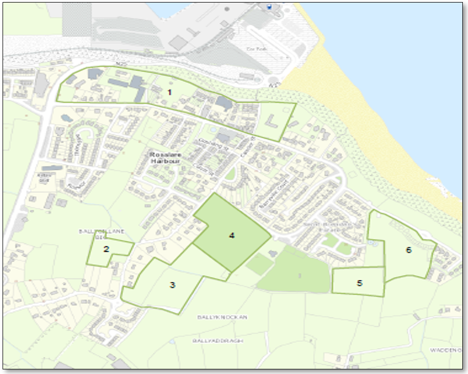
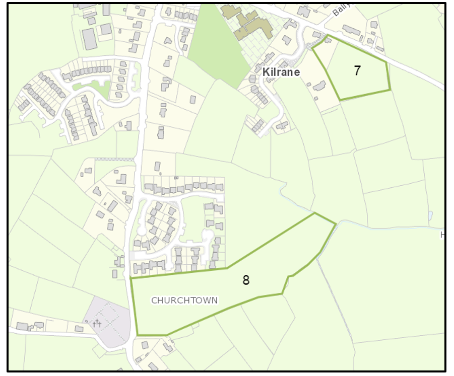
Map 7: Site No.1
These lands are located at the village centre extending from the N25 to the former meteorological research station on the L3066, with, on its northern side, a frontage also to a cliff top walk overlooking the port. These lands have a variety of current uses including residential, retail and petrol filling station. There are a number of significant vacant sites and buildings formerly occupied by hotels. The lands would be suitable for regeneration for a variety of village centre uses including residential.
There is currently footpath and street lighting provision on most of the L3066 frontage and on the cliff top walk. Where gaps in footpath provision exist, e.g. to the frontage of the former Great Southern hotel, this could be provided as part a redevelopment of the site. The L3066 is of suitable width and although the road surface is currently in a moderate condition only in parts, it is not considered to be in such poor condition to prevent further development on the lands.
The site could be served by existing water, wastewater and surface water arrangements on the L3066 with site/development specific upgrades as necessary.
The site is considered to have Tier 1 status.
Map 8: Site No. 2
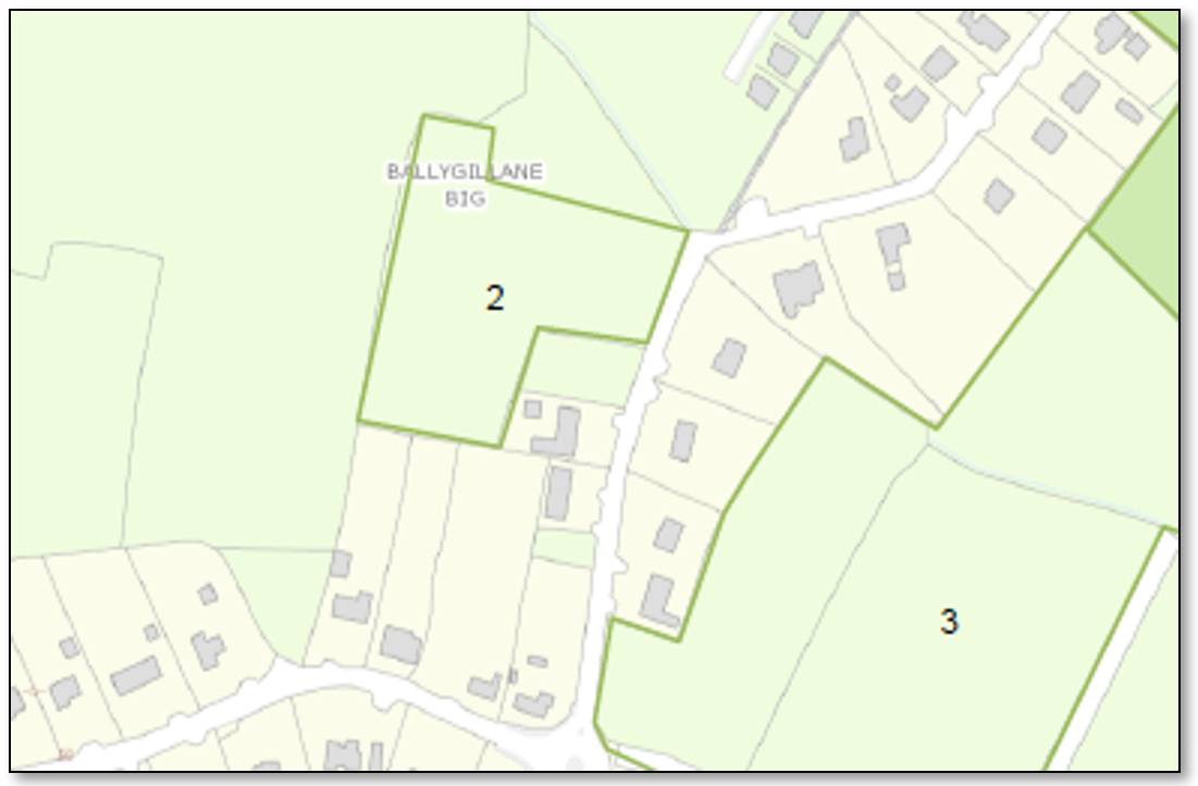
Located at Ballygillane Big, with a frontage to the L7120 Ballygillane Lane, this land is currently undeveloped and is bounded by existing residential development to the north, east and south. To the west, the site is bounded by lands with port-related and community and education uses.
There is currently no footpath provision on Ballygillane Lane to the north or south of the frontage. The lack of footpath extends approximately 950m to Kilrane Village to the south, and approximately 325m north to an existing footpath. There is an objective in the Settlement Plan to improve footpath provision on Ballygillane Lane, and the cost of providing a footpath to Kilrane to the south would be approximately €95,000. To the north the provision of a connecting footpath would cost approximately €32,000. It is noted that Ballygillane Lane narrows significantly to the south of the site with limited room for a 1.5-2m wide footpath and 5.5m wide road carriageway.
Whilst the site is located on a bend, the frontage will be able to accommodate a safe vehicular access.
Street lighting to the south of the site is very limited and the cost of providing street lighting could be approximately €27,750 in addition to footpath costs. To the north of the site frontage existing street lighting is limited but better.
The site could be served by existing water, wastewater and surface water arrangements on the L7120 with site/development specific upgrades as necessary. Connection of a development to the wastewater network could potentially require upgrades to the Ballygillane Big pumping station. The cost of such upgrades would be dependent on the scale of development being undertaken.
The site could potentially be serviced via the existing Portside development and by a new link between the N25 and L7120 but this would require the consent of and/or, works undertaken by, others.
The site is considered to have Tier 2 status.
Map 9: Site No.3
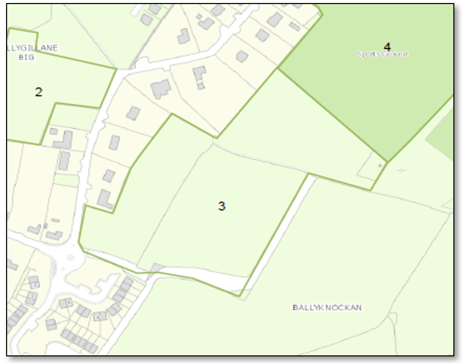
These undeveloped lands have backland type characteristics behind detached residential properties with a 50m frontage to the L7120 Ballygillane Lane. The eastern side of the site is undeveloped, the northern side adjoins Site No. 4 discussed below.
There is currently no footpath provision on Ballygillane Lane to the north or south of the frontage. To the south, the lack of footpath extends approximately 760m to Kilrane Village, to the south approximately 480m to an existing footpath. There is an objective to improve footpath provision on Ballygillane Lane in the Rosslare Harbour and Kilrane Settlement Plan, and the cost of providing a footpath to Kilrane to the south would be approximately €76,000. To the north the provision of a connecting footpath would cost approximately €48,000. It is noted that Ballygillane Lane narrows significantly to the south of the site with limited room for a 1.5-2m wide footpath and 5.5m wide road carriageway.
Street lighting is very limited to the north and south and the cost of providing street lighting could be approximately €30/metre in addition to footpath costs.
There is space for a vehicular access to be safely provided to the site from the L7120.
The site could be served by existing water, wastewater and surface water arrangements on the L7120 with site/development specific upgrades as necessary. Connection of a development to the wastewater network could potentially require upgrades to the Ballygillane Big and/or the St Brendan’s pumping stations. The cost of such upgrades would be dependent on the scale of development being undertaken.
The site could also potentially be accessed and serviced via a future development of the lands adjoining to the north (Site No. 4).
The site is considered to have Tier 2 status.
Map 10: Site No.4
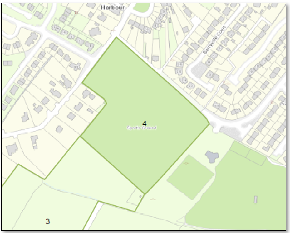
This is undeveloped land with a frontage to the L7120 Ballygillane Lane. The site is currently undeveloped with a former use as a GAA grounds. To the north and west is residential development, to the south is Site 5 as discussed below, to the southeast the grounds of the Rosslare Rangers AFC.
There is an existing footpath extending to the northern edge of the frontage on the L7120 and whilst it is of moderate to poor standard of construction currently, the footpath does ultimately connect without significant gaps to the village centre. There is space to provide an extension to the footpath network across the frontage of the site. There is reasonable existing street lighting provision to the L7120 to the north of the site.
The site frontage is capable of accommodating a safe vehicular access. The majority of the site would be able connect to the existing water supply and wastewater pipes on the L7120 subject to site/development specific works as necessary. A smaller part of the site, at its south-eastern edge, may need to connect to the public sewers via the St Brendan’s pumping station which may require upgrades.
Surface water can be managed using existing pipes with site/development specific works as necessary.
The site is considered to have Tier 1 status.
Map 11: Site No.5
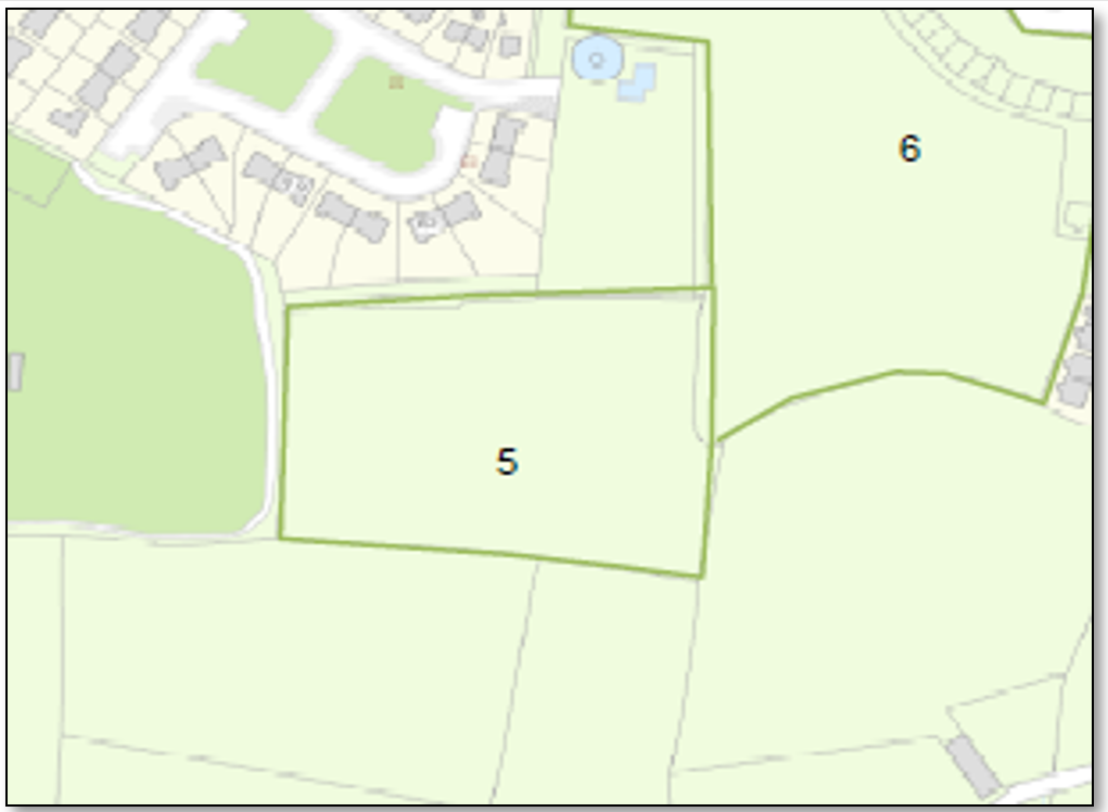
Located southeast of the St Brendan’s estate, the site is also adjoined by the Wexford County Council water facility to the north and by the community sports grounds to the west.
The site does not currently have direct road and footpath access to the settlement’s network. However, the lands can be accessed in tandem with the development of Site No. 6.
Wastewater would need to flow via the existing Barr na hAille and/or St Brendan’s pumping stations which may require significant upgrades to cater for demand from the site and also Site No. 6 as discussed below.
Water supply could be achieved via the adjoining water services site.
New surface water pipes to the site may need to be provided.
The site is considered to have Tier 2 status.
Map 12: Site No. 6
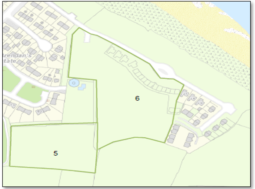
This site is comprised of undeveloped land adjoining St Brendan’s Estate and Barr na hAille Housing Development. Frontage is onto a relatively new road L30671. Land to the south is undeveloped.
It will be possible to form safe access to the site directly from the L30671.
Wastewater would need to flow via the existing Barr na hAille and/or St Brendan’s pumping stations which are likely to significant upgrades to cater for demand from the site.
It should be possible to connect to the existing water supply arrangements serving Barr na hAille.
Surface water could be managed via existing pipes, with site/development specific upgrades as necessary.
The site is considered to have Tier 2 status.
Map 13: Site No. 7
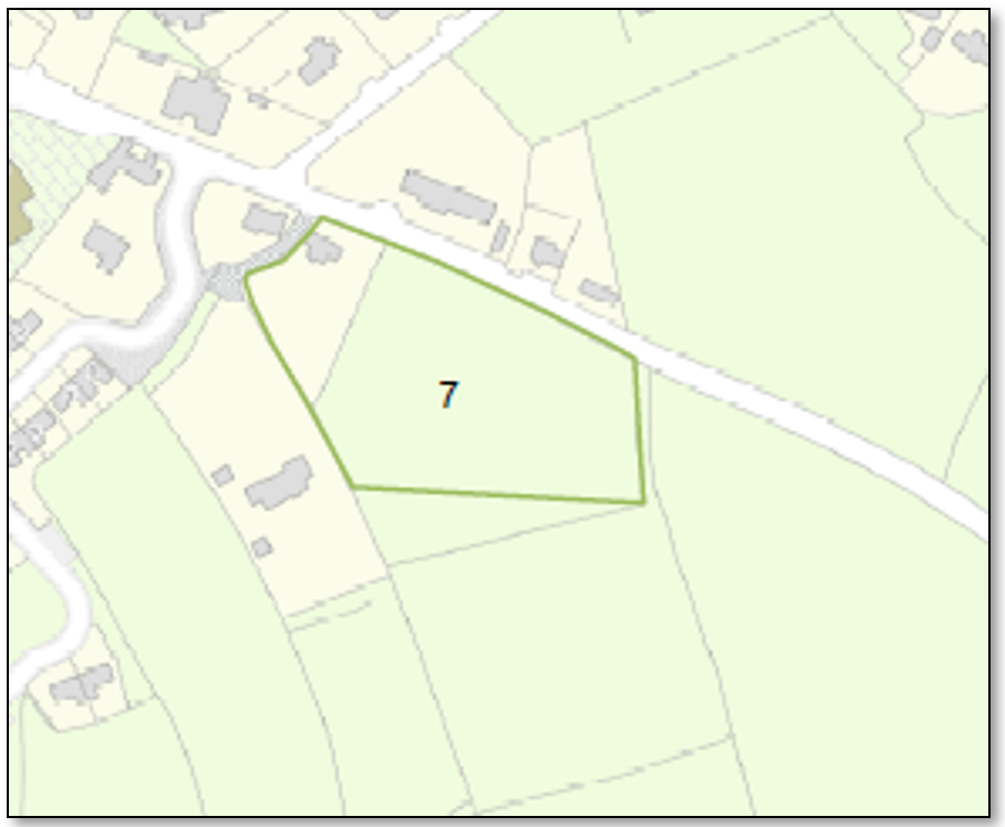
The site is comprised of a partially constructed dwelling and adjoining undeveloped land with a frontage to the L7102 which has a 50kmh speed limit at this point.
It will be possible to form a safe access to the site from the R7102.
A footpath has recently been constructed on the L7102 extending from Kilrane village centre to the Cúl na Gréine estate approximately 150m to the east, although as of yet there is no street lighting. The existing street lighting to Kilrane village centre stops approximately 60m from the site. The cost of extending lighting to the street frontage would be approximately €1,800.
It should be possible to connect to existing water pipes serving the Cúl na Gréine estate but connection to sewers will likely require works off site as the Ballygillane Small pumping station is currently overloaded and Ballygeary pumping station may been to be upgraded.
Surface water could be managed via existing pipes, with site/development specific upgrades as necessary.
The site is considered to have Tier 2 status.
Map 14 Site 8
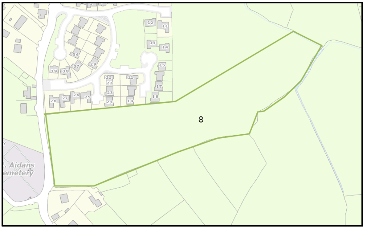
The site is comprised of approx. 3.45ha of undeveloped land, mostly in a backland type position with a road frontage of approximately 110m to the L7107 to the south of the Westwinds estate adjoining to the north. The L7107 which has an 80kmh speed limit at this frontage, the 50kmh speed limit sign for Kilrane village is approximately 50m to the north.
Notwithstanding the 80kmh speed limit it would be possible to form a safe vehicular access to the site from the L7107.
There is no footpath currently on the site’s frontage. There is an existing footpath with streetlighting to the entire frontage of the Westwinds estate which extends to the very northern edge of the site frontage. The footpath with street lighting on this side of the L7107 extends almost uninterrupted to the centre of Kilrane village, approximately 600m to the north.
It should be possible to connect to existing water pipes on the L7107. There is an existing public sewer line on the L7107, although upgrades to pumping station(s) may be necessary and/or connections via existing estates may be necessary.
Surface water could be managed via existing pipes, with site/development specific upgrades as necessary.
The site is considered to have Tier 2 status.
- 6The EU TEN-T network comprises roads, railway lines, inland waterways, inland and maritime ports, airports and rail-road terminals throughout the Member States. The Network aims to achieve efficient, safe and seamless transport chains for passengers and freight.
- 7 Many uses are open for consideration on the village centre sites including residential (dwellings, nursing homes, retirement villages, sheltered apartments), offices, tourism (hotels/holiday homes/short term letting). These sites may or may not be developed for residential As such it not possible to estimate the % that may be developed for residential (if any) and therefore these lands are not included in the core strategy residential calculations.
- 8 Note - the map numbering in the IAR continues the map numbering in the Rosslare Harbour and Kilrane Settlement Plan. Accordingly, the first map number in the IAR will read as Map 5 and will continue from there.