Chapter 9: Infrastructure Strategy
9.1 Introduction
The Council has many responsibilities and functions that relate to the sustainable planning, delivery and management of public and private infrastructure. The Council, through its statutory land use plans and development management functions, plan and manage the provision of infrastructure in the county. A development plan must make provision for infrastructure including transport, energy, communications, water and wastewater services, waste recovery and disposal facilities and any ancillary facilities or services.1
Local authorities now have an enhanced role in promoting economic development and local authorities are regarded as important enablers of economic development with many of their mainstream functions, in particular, planning and infrastructure, critical to enterprise and economic activity. A planned approach to infrastructure delivery will maximise returns on the investment made in terms of economic development and job creation and contribute to a good quality of life and wellbeing for all residents.
For the purposes of this chapter, the term infrastructure extends to water, wastewater, waste management, telecommunications and ICT infrastructure. It also relates to flood risk and surface water management. Transport infrastructure is dealt with in Chapter 8 Transportation Strategy and Green Infrastructure is dealt with in Chapter 11 Landscape and Green Infrastructure. This chapter provides the spatial framework and objectives for the planning and provision of this infrastructure, either directly by the Council, or by other agencies or operators. This provision must also have regard to the Council’s other functions including their environmental responsibilities and ensuring compliance with relevant European and National legislation. This chapter should be read in conjunction with the other chapters in the plan, in particular, Chapter 10 Environmental Management and the Development Management Manual in Volume 2.
9.2 Climate Action and Infrastructure Planning
Much of this infrastructure is essential to emergency planning and response in times of extreme weather events/critical incidents e.g. telecommunications. To this end:
- Infrastructure developed above ground should avoid flood risk areas and areas at risk of coastal erosion.
- Site selection, location, design and materials will need to have regard to and be resilient to the changing climate (high winds, temperature fluctuations, increased storminess and changes in rainfall).
- Infrastructure developed below ground should avoid flood risk areas and areas at risk of coastal erosion.
9.3 Policy Context
The preparation of this chapter had regard to relevant national legislation and guidelines, regional and local plans and policies, in particular, the need to ensure that the Plan is compliant with the Water Framework Directive, the Habitats Directive and all other relevant EU and national legislation and regulations in relation to the protection of water quality and waste management.
The most significant change in recent years has been the establishment of Irish Water who became responsible for all public water services involving the supply of drinking water and the collection, treatment and disposal of wastewater. While the Council, through a Service Level Agreement with Irish Water, continues to provide day to day operations, all capital investment decisions and the implementation of the capital programme delivery across the country is the responsibility of Irish Water.
The Water Services Strategic Plan (WSSP) sets out Irish Water’s strategic objectives for the delivery of water services in Ireland up to 2040 and identifies current and future challenges regarding the provision of the services. It identifies priorities to be tackled in the short to medium term. The Council will work closely with Irish Water to ensure that the provision of water and wastewater infrastructure will not be a limiting factor in terms of achieving targeted population growth and employment growth as set out in the Core Strategy, Settlement Strategy and Economic Development Strategy of this Plan.
9.4 Infrastructure Strategy
This strategy is focused on the provision of high quality water, wastewater and waste management facilities and telecommunications infrastructure that will facilitate and sustain the planned growth of the county over the lifetime of the Plan and beyond.
9.4.1 Goal
The overall goal is to ensure that Wexford has high quality infrastructure to facilitate and sustain the growth of the county over the lifetime of the plan and beyond whilst having regard to, and complying with, all relevant EU Directive and national legislation and enhancing the environmental quality of the county.
9.4.2 Strategy
- To facilitate Irish Water in the protection, improvement and conservation of the county’s water resources and in the provision of necessary water services infrastructure to support the growth of the county in a sustainable manner and in accordance with all relevant EU and national legislation and guidance.
- To facilitate the provision of key infrastructure in a timely manner to support the growth of county in line with the Core Strategy, Settlement Strategy and Economic Development Strategy.
- To facilitate the delivery of private water and waste water infrastructure in accordance with all relevant EU and national legislation and guidance.
- To promote and facilitate best practice in the prevention, re-use, recovery, recycling and disposal of all waste produced in the county
- To facilitate the development of high speed telecommunications and ICT infrastructure throughout the county in order to grow and develop economic activity, to enhance learning and education facilities and contribute to the social wellbeing of our residents, particularly in rural areas in the county.
- To minimise the risk to people, businesses, infrastructure and the environment through the identification and management of existing and potential future flood risk.
Strategic Objectives
It is the objective of the Council:
Objective IS01
Objective IS02
Objective IS03
Objective IS04
Objective IS05
Objective IS06
Objective IS07
9.5 Water Supply
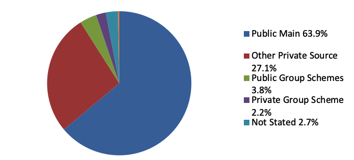
The county’s drinking water supplies are derived from natural resources, either surface water or ground water and it is therefore important that these resources are protected so that reliable, safe and good quality water supplies are always available. The provision of reliable water supplies is also critical to achieve the growth planned for the county for the period of this plan, in particular, population and economic growth. Figure 9-1 details the breakdown of water supply to households recorded in Census 2016.
Figure 9-1 Sources of Water Supply in County Wexford, 2016
Source: CSO Census 2016
9.5.1 Public Water
Census 2016 recorded that 64% of private households in the county were served by public water supplies which was considerably lower than the State average (77%). Relative to other local authority areas, Wexford had the 15th highest number and the 7th lowest rate of households with ‘public main’ water supply. It is a priority of the Council to increase the number of households served by public water in the interest of protecting water resources, sustainable development and maximising investments in this infrastructure. In this regard, the Council will require developments to connect to public water supply, where available, rather than providing a private well on site.
Table 9.1 lists Irish Water Public Water Supplies and Capacities based on information received in March 2022. The table includes reference to the settlements where supply issues have been identified.
Table 9-1 Irish Water Public Water Supplies and Capacities
Source: Irish Water March 2022
|
Settlement Hierarchy |
Settlement |
Water Resource Zone (WRZ) |
Capacity of source/treatment |
|
Level 1 Key Towns |
Wexford Town |
South East Wexford |
Capacity available in the main networks to cater for the 2027 population target. Capacity is available in the WRZ to cater for the population targets with assistance of water conservation measures and network improvements to provide the level of services required. |
|
Gorey |
Gorey |
Capacity available in the main networks serving the town and in the WRZ to cater for the 2027 population target. |
|
|
Level 2 Large Towns |
Enniscorthy Town |
Enniscorthy |
Capital upgrades are progressing to increase capacity for the town which will allow additional water to be delivered into the town. There is capacity available in the main networks to cater for the 2027 population target. Capital upgrades required to the WRZ. There is a project in the Capital Investment Programme which will be delivered during the lifetime of the Plan. |
|
New Ross Town |
New Ross |
Capacity available in the main networks supplying the town. Capacity available in the WRZ to cater for the population targets to 2027 with assistance of water conservation measures and network improvements to provide the level of services required.
|
|
|
Level 3a Service Settlements |
Bunclody Town |
Bunclody |
Capacity available in the main networks to cater for the 2027 population target. Capacity available in the WRZ but not for the full 2027 population target. A project is progressing to increase capacity which is anticipated will be completed within the lifetime of the Plan. |
|
Castlebridge |
South East Wexford |
Capacity available in the main networks supplying the village to cater for the 2027 population targets. Capacity potentially available in the WRZ to cater for the 2027 population targets with the assistance of water conservation measures and network improvements to provide the level of service required. |
|
|
Courtown and Riverchapel |
Gorey Rural |
Capacity available in the main networks serving the villages and in the WRZ to cater for the 2027 population target. |
|
|
Ferns |
Ferns Regional |
Capacity is available in the main networks supplying the village to cater for the 2027 population targets. Capacity is potentially available in the WRZ to cater for those targets with the assistance of water conservation measures and network improvements to provide the level of service required. |
|
|
Rosslare Harbour and Kilrane |
South East Wexford |
Capacity available in the main networks serving the villages and in the WRZ to cater for the 2027 population target. |
|
|
Rosslare Strand |
South East Wexford |
Capacity available in the main networks serving the village and in the WRZ to cater for the 2027 population target. |
|
|
Level 3b Strategic Settlements |
Bridgetown |
South East Wexford |
Capacity available |
|
Campile |
South East Wexford |
Capacity available |
|
|
Clonroche |
Clonroche |
Currently limited capacity. Solutions for improving capacity are being assessed through the full options assessment stage of the NWRP, due to be completed in mid-2021. In addition, the solutions will address treatment issues. |
|
|
Coolgreany |
Coolgreany |
Capacity available |
|
|
Kilmore Quay |
South East Wexford |
Capacity available |
|
|
Kilmuckridge |
Gorey |
Capacity available | |
|
Taghmon |
South East Wexford | Capacity available | |
|
Wellingtonbridge |
South East Wexford |
Capacity available |
|
|
Level 4
Large Villages |
Adamstown | Adamstown | Capacity available |
| Ballaghkeen | South East Wexford |
Capacity available |
|
| Ballindaggin | Ballindaggin |
Limited capacity available |
|
|
Ballycanew |
Gorey |
Capacity available |
|
| Ballycullane | South East Wexford |
Capacity available |
|
| Ballyhack | South East Wexford |
Capacity available |
|
| Ballyhogue | Ballyhogue | Capacity available | |
|
Ballymurn |
South East Wexford |
Capacity available |
|
|
Barntown |
South East Wexford |
Capacity available |
|
| Blackwater | Sow | Capacity available | |
| Bree | Bree | Capacity available | |
|
Camolin |
Camolin |
Capacity available |
|
| Carrig-on-Bannow | South East Wexford | Capacity available | |
| Clongeen | South East Wexford | Capacity available | |
|
Duncannon |
South East Wexford | Capacity available | |
|
Fethard-on-Sea |
South East Wexford | Capacity available | |
|
Murntown |
South East Wexford | Capacity available | |
|
Oilgate |
South East Wexford | Capacity available | |
| Oulart | Sow | Capacity available | |
|
Piercestown |
South East Wexford | Capacity available | |
|
Ramsgrange |
South East Wexford | Capacity available | |
|
Tagoat |
South East Wexford | Capacity available |
Table 9-2 lists the proposed public water supply projects in the county identified in the Irish Water Capital Investment Plan 2020-2024. The Council will work alongside Irish Water to facilitate the delivery of these and any other public supply water projects that may arise during the lifetime of this Plan.
Table 9-2 Proposed Irish Water Public Water Projects 2020-20242
Source: Irish Water Capital Investment Programme 2020-2024
|
Project |
Project Description |
|
Gorey Regional Water Supply Contract 4 (Water Treatment Plant, reservoir and pumping station) |
Provision for Water Treatment Plant (WTP) and upgrade to address drinking water quality and demand deficiencies associated with Ballyminaun, upgrade Barnadown pumping station, interconnecting network and provision for reservoir at Ballyminaun WTP. Additional decommissioning of Barnadown WTP, Kilmuckridge WTP, Ballykale WTPs and Coolishall WTPs. |
Clonroche is currently the only water supply on the EPA’s Drinking Water Remedial Action List due to ‘elevated levels of pesticides above the standard in the Drinking Water Regulations’. The proposed action is a complete catchment-focused engagement involving Irish Water and the relevant stakeholders to achieve compliance with the limits for pesticides. This action programme is to be completed by January 2021 in line with the EPA’s direction.
9.5.2 Group Water Schemes and Private Water Supplies
As highlighted in Figure 9-1, many of the county’s households obtain their water supply from group water schemes or private wells. These supplies provide alternatives for areas that are not served by public water supply infrastructure and comprise mainly of group water schemes for rural clusters and small settlements and private wells for individual dwellings, farms and other developments
Private wells/‘other private source’ accounted for 27.2% of water supply to households in Census 2016. This rate was considerably higher than the State average (10.1%) and was the highest rate of all local authorities. This is reflective of our rural settlement pattern and raises issues around sustainability of this pattern of development.
The Rural Water Programme facilitates the development of water services in rural areas and it plays an important role in helping to improve deficiencies in group water schemes and private supplies where no alternative group or public water scheme is available. Investment under the programme is prioritised for upgrades which help to deliver measures identified in the National River Basin Management Plan to meet the Water Framework Directive, to meet the requirements of the Drinking Water Directive and the overall proper planning and sustainable development of rural areas.
9.5.3 Groundwater Protection Schemes
Groundwater Protection Schemes seek to preserve the quality of groundwater in the county for drinking purposes, for the benefit of present and future generations. These schemes provide guidelines to the Council when carrying out its planning and licensing functions and assist in decision-making relating to controlling the location and nature of developments and activities of potentially polluting activities.
9.5.4 Water Conservation
Water conservation is key to the sustainable use of our water resources and it is a priority in all areas of the county, whether served by public or private supplies. Irish Water is currently implementing a Leakage Reduction Programme which is focused on providing a reliable uninterrupted water supply, improved water quality, reduced leakages and improved supply connections. The Council will facilitate the delivery of this programme and encourage all new developments to incorporate appropriate water conservation measures.
Water Supply Objectives
It is the objective of the Council:
Objective WS01
Objective WS02
Objective WS03
Objective WS04
Objective WS05
Objective WS06
Objective WS07
Objective WS08
Objective WS09
To protect water services abstraction points and infrastructure from inappropriate development and zoning.
Objective WS10
To protect existing way leaves and areas, including buffer zones, around public water services infrastructure through appropriate zoning and to facilitate the provision of appropriate sites for public water infrastructure, as required.
Objective WS11
To ensure that development proposals comply with the standards and requirements of the Irish Water: Code of Practice for Water Infrastructure (July 2020), and any updated version of this document during the lifetime of the plan.
Objective WS12
Objective WS13
To promote rain water harvesting systems to reduce the need for main water usage.
Objective WS14
To support the provision of appropriately designed and located available tap water refill points in settlements and other locations in the county.
9.6 Wastewater
The treatment and disposal of wastewater in an environmentally sound manner is important not only for human health but also for the social and economic development of the county. Pollution from wastewater treatment facilities arises where there is inadequate treatment; storm water overflows operating incorrectly; or direct discharges of untreated wastewater3.
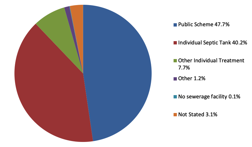
Wastewater is disposed of to either a public wastewater treatment system or to a private individual wastewater treatment system. Figure 9-2 details the types of wastewater disposal for private households in the county in 2016. It is essential that all wastewater is treated in accordance with best practice to ensure the protection of the environment and public health.
Figure 9-2 Types of Wastewater Disposal in County Wexford, 2016
Source: CSO Census 2016
9.6.1 Public Wastewater Facilities
According to Census 2016, the dominant form of wastewater disposal was ‘Public Scheme’ with a rate of 47.7% (25,742 households). This is considerably lower than the State average of 65.9%. Relative to other local authorities, Wexford has the 14th highest number of households and the 10th lowest rate of households using a ‘public scheme’.
Table 9-3 lists the settlements in Levels 1-4 in the Settlement Strategy, the capacity of their wastewater treatment plants and available headroom (as of 29th April 2020).
- Level 1 and 2 settlements have sufficient headroom.
- Of the 14 Level 3a Service and Level 3b Strategic settlements, three have no headroom – Kilmore Quay, Campile and Wellingtonbridge.
- Of the 25 settlements at Level 4 Large Villages, five have no headroom – Ballycanew, Camolin, Clongeen, Duncannon, Fethard-on-Sea and there are no public wastewater facilities in Ballyhack, Craanford and Ramsgrange.
- In addition, 16 of 35 Level 5 settlements have public wastewater facilities with varying amounts of available headroom in all but two of those settlements (Davidstown and Boolavogue).
Table 9-3 Overview of Public Wastewater Infrastructure in Level 1-Level 4 Settlements
Source: Irish Water Wastewater Capacity Register 29th April 2020. This is subject to change.
|
Settlement Hierarchy |
Settlement |
Capacity |
Headroom |
|
Level 1 Key Towns |
Wexford Town |
45,000 |
14,011 |
|
Gorey |
36,000 |
14,442 |
|
|
Level 2 Large Towns |
Enniscorthy Town |
26,200 |
12,451 |
|
New Ross Town |
16,000 |
6,038 |
|
|
Level 3a Service Settlements |
Bunclody Town |
6,500 |
3,883 |
|
Castlebridge4 |
- |
|
|
|
Courtown and Riverchapel5 |
- |
|
|
|
Ferns |
2,000 |
449 |
|
|
Rosslare Harbour and Kilrane |
9,383 |
6,885 |
|
|
Rosslare Strand |
8,500 |
2,826 |
|
| Level 3b Strategic Settlements |
Bridgetown |
2,000 |
1,305 |
|
Campile |
150 |
0 |
|
|
Clonroche |
650 |
166 |
|
|
Coolgreany |
2,400 |
1,171 |
|
|
Kilmuckridge |
2,000 | 475 | |
| Kilmore Quay |
- |
0 |
|
|
Taghmon6 |
- |
|
|
|
Wellingtonbridge |
37 |
0 |
|
|
Level 4 Large Villages |
Adamstown |
500 |
162 |
|
Ballaghkeen |
650 |
185 |
|
|
Ballycanew |
100 |
0 |
|
|
Ballycullane |
400 |
251 |
|
| Ballindaggin | 108 | 18 | |
| Ballyhack | 0 | 0 | |
|
Ballyhogue |
178 |
45 |
|
|
Ballymurn |
650 |
77 |
|
| Ballywilliam | 310 | 206 | |
|
Barntown7 |
- |
|
|
|
Blackwater |
2,000 |
925 |
|
|
Bree |
300 |
68 |
|
|
Camolin |
100 |
0 |
|
|
Carrick-on-Bannow |
600 |
341 |
|
|
Clongeen |
220 |
0 |
|
| Craanford8 | 0 | ||
|
Duncannon |
- |
- |
|
|
Fethard-on-Sea |
150 |
0 |
|
|
Killinerin |
300 |
42 |
|
|
Murntown9 |
- |
|
|
|
Oilgate |
157 |
47 |
|
|
Oulart |
350 |
127 |
|
|
Piercestown10 |
- |
|
|
|
Ramsgrange11 |
0 |
|
|
|
Tagoat |
800 |
319 |
The EPA Urban Waste Water Report 2018 highlighted eight areas in the county which need to be addressed. These are listed in Table 9-4.
Table 9-4 EPA Urban Wastewater Areas of Concern
Source: Urban Wastewater Report EPA, Wexford County Council Water Services Section
|
Settlement |
Reason |
|
Arthurstown, Ballyhack, Duncannon and Kilmore Quay |
Discharging untreated waste water to the environment. |
|
Ballycanew, Clonroche and Coolgreany. |
Putting pressures on inland and/or coastal waters. |
9.6.2 Planned Public Wastewater Projects
The planned upgrades to the Irish Water public wastewater facilities are listed in Table 9-5. Some of these projects will address the EPA’s issues relating to Arthurstown, Ballyhack, Duncannon and Kilmore Quay.
Table 9-5 Irish Water Investment Plan Public Wastewater Projects 2020-202412
|
Project |
Project Description |
|
Kilmore Quay Village and Environs Waste Water Outfall |
Provision for the Waste Water Treatment Plant (WWTP) to protect environment and quality of receiving waters, increase capacity and facilitate future growth. Completion expected Q1, 2024. |
|
Duncannon WWTP |
Provision for the WWTP to protect environment and quality of receiving waters, increase capacity and facilitate future growth. Completion expected Q1 2023. |
|
Enniscorthy WWTP |
Upgrade of WWTP to protect environment and quality of receiving waters and facilitate growth. Construction completed and WWTP upgrade is commissioned and operational. |
|
Enniscorthy Main Drainage |
Upgrade of the foul collection network in the town of Enniscorthy, Co Wexford. |
|
Wexford Town Distillery Road PS Upgrade |
Provision of infrastructure to facilitate growth and address existing capacity issues by increasing the capacity of the wastewater network entering the existing WWTP. |
The following projects also form part of the Capital Investment Programme (CIP) 2020 – 2024. These projects have been re prioritised by Irish Water due to financial restraints and are now very unlikely to be delivered within the lifetime of the current CIP :
- The Fethard-on-Sea WWTP was due to be delivered in 2022 but is now unlikely to be built before 2025.
- An upgrade to the Slaney water intake in Clohaston Enniscorthy has been granted planning permission but is unlikely to be constructed within the current CIP.
- The Ferns WWTP upgrade will probably complete design within the CIP but will not go to construction.
While there is sufficient headroom in the Level 1 and Level 2 settlements to accommodate the planned population and economic growth for those locations during the lifetime of the Plan, there are still significant deficiencies, particularly in our large and small villages. These deficiencies will undermine the ability of the Council to achieve the implementation of growth targets and objectives set by the NPF, in particular, NPO 4, 5, 6, 7, 9, 18a and 18b. Accordingly, it remains a priority of the Council that Irish Water aligns their work programme with the Plan's Core Strategy and Settlement Strategy to secure the NPO objectives and address possible risks of pollution and environmental damage.
9.6.3. Small Towns and Villages Growth Programme
NPO 18b in the NPF introduced the concept of a programme for ‘new homes in small towns and villages’. This programme will be developed with local authorities, public infrastructure agencies such as Irish Water and local communities to provide serviced sites with appropriate infrastructure to attract people to build their own home and live in small towns and villages.
The Council welcomes this programme, and its potential to re-invigorate our large and small villages and to offer a much needed alternative to one-off rural housing which is a significant pressure point in the county. While all of our smaller towns and villages would benefit from this programme, the candidate settlements are listed in Table 9-6.
Table 9-6 Candidate settlements for the New Homes in Small Towns and Villages Growth Programme
|
Settlement |
Settlement Level |
|
Wellingtonbridge |
3b |
| Campile | 3b |
| Adamstown |
4 |
|
Ballindaggin |
4 |
| Ballycanew | 4 |
| Camolin | 4 |
| Clongeen | 4 |
| Killinerin | 4 |
|
Oilgate |
4 |
| Tagoat | 4 |
| The Ballagh | 4 |
| Davidstown | 5(1) |
Communal private waste water treatment plants will not be considered for residential developments. Private waste water treatment plants will be considered in exceptional circumstances for commercial and tourism uses. The Council will give careful consideration to such proposals, and at minimum will only consider proposals where the communal wastewater treatment system will be retained in single ownership. This is required to ensure that the system will be properly maintained. The Council must also be satisfied that the development complies with all relevant EPA guidance, EU Directives and the normal planning and environmental criteria.
9.6.4 Individual Private Wastewater Systems in Rural Areas
As identified in Figure 9-2, 47.9% of private households in the county were served by a private individual septic tank or other type of individual treatment system. This rate was considerably higher than the State average of 28.8%. This is reflective of our rural settlement pattern, the high dependency on individual treatment systems and the lack of investment in public waste water treatment plants in the rural villages of the county.
The provision of on-site wastewater treatment systems to serve new one-off rural housing must be carefully considered as these systems place significant pressure on water quality. In this regard:
- Particular protection will be afforded to the catchments of ‘high’ status surface water bodies in order to protect this status and ensure there is no deterioration of water quality. The development of the Blue Dot Catchments for the protection of high status waters will play an important role in this13. The extension of the grant scheme for repairs, upgrade and replacement of domestic waste-water treatment systems will give priority to high-status catchments.
- Equally, these developments will be carefully considered in areas where the water quality status is less than ‘good’ (in order not to deteriorate water quality further in pursuit of the WFD objective to achieve at least ‘good’ status in all our waterbodies by 2027).
- The same approach will apply to ground water bodies in the county in order to maintain ‘good’ status and improve the ‘poor’ status ground waterbodies.
For new development where it is proposed to serve a dwelling house with a domestic wastewater treatment system, it must be demonstrated that the proposed onsite system can safely and adequately dispose of the effluent in accordance with the Code of Practice: Wastewater Treatment and Disposal Systems serving Single Houses (EPA 2021) and complies with the Water Framework Directive and the provisions of the relevant River Basin Management Plan.
It is essential that these systems are properly installed, regularly monitored and maintained so as protect public health and the environment. The Council will continue to carry out inspections under the National Inspection Plan for Domestic Wastewater Treatment Systems-the aims of which is to protect human health and water quality from the risks posed by these systems.
9.6.5 Wastewater Treatment Systems and Private Wells
Many private wells are at risk of contamination from sources such as wastewater treatments systems. Recommended separation distances have been established between onsite wastewater treatment systems (specifically the percolation area or polishing filter) and wells or boreholes. Table B.3 of the EPA's Code of Practice specifies the recommended minimum distances taking into consideration a number of factors. These factors include the permeability of the soil/subsoil, the permeability of the bedrock, the flow direction of the groundwater and the level of treatment of the effluent. Distances may be increased where the bedrock is shallow, preferential flow paths are present or the effluent and bacteria enter the bedrock rapidly.
The Council may consider alternative individual treatment systems for existing developments only, where ground conditions are such that the existing system, per the EPA Code of Practice, would not treat effluent satisfactorily (such alternatives may include zero discharge systems).
Wastewater Objectives
It is the objective of the Council
Objective WW01
Objective WW02
Objective WW03
Objective WW04
Objective WW05
Objective WW06
Objective WW07
Objective WW08
Objective WW09
Objective WW10
To consider the development of private wastewater treatment systems to serve commercial and tourism uses (employment generating developments) outside of serviced settlements and in rural areas where the system is in single ownership and where it is demonstrated to the satisfaction of the Planning Authority that the proposed wastewater treatment system is in accordance with the ‘Code of Practice Wastewater Treatment and Disposal System Serving Single Houses, EPA 2021 and Wastewater Treatment Manuals – Treatment Systems for Small Communities, Business, Leisure Centre and Hotels, EPA 1999’, and any updated versions of these documents during the lifetime of the Plan, the Water Framework Directive, the National River Basin Management Plan 2018-2021, the Habitats and Shellfish Waters Directives and relevant Pollution Reduction Programmes.
Objective WW11
To consider the development of single dwelling houses only where it is demonstrated to the satisfaction of the Planning Authority that the proposed wastewater treatment system is in accordance with the ‘Code of Practice Wastewater Treatment and Disposal System Serving Single Houses, EPA 2021' and any updated version of this document during the lifetime of the Plan, and maintained in accordance with approved manufacturer’s specifications and subject to compliance with the Water Framework Directive, the National River Basin Management Plan 2018-2021, the Habitats and Shellfish Waters Directives and relevant Pollution Reduction Programmes.
Objective WW12
To work with Irish Water to examine the feasibility of connecting unsewered areas, including individual properties and premises served by on-site wastewater treatment facilities to existing and planned wastewater networks.
Objective WW13
To protect existing wastewater infrastructure, including way leaves and buffer zones, from inappropriate development and zoning.
Objective WW14
9.7 Waste Management Infrastructure
One of the key drivers for a sustainable economy is the concept of a ‘circular’ economy which aims to reduce waste and ensure that materials are used as efficiently as possible. Being more circular involves getting the most from products by using them as fully as possible; by sharing items with others to re-use where possible; and by increasing our levels of recycling to at least recover the value of the materials used to make these products. For businesses, the circular economy reduces costs, improves the raw material supply chain and offers opportunities such as new business models and markets. For individuals, the circular economy offers a sustainable lifestyle with reduced environmental impact and lower household bills14 .
The NPF, though NPO 56, aims to sustainably manage waste generation, invest in different types of waste treatment and support circular economy principles, prioritising prevention, reuse, recycling and recovery, to support a healthy environment, economy and society. The RSES supports the development of a circular economy, and will support the use of smart technologies and innovative approaches to waste management which promote waste prevention and increased reuse, recycling and recovery of waste, with additional environmental benefits.
The European Commission’s Circular Economy Action Plan: 'A New Circular Economy Action Plan for a Cleaner More Competitive Europe', launched in March 2020, forms one of the main blocks of the European Green Deal. The New Circular Economy Action Plan builds on the aims and achievements of the first Circular Economy Action Plan 'Closing the Loop' which was launched in 2015.
The Southern Regional Waste Management Plan 2015-2021 (SRWMP) embraces the circular economy approach and provides the framework for the prevention and management of waste in a safe and sustainable manner. The targets of the plan include a 1% reduction in the quantity of household waste generated per capita over the period of the plan, achieve a recycling rate of 50% of managed municipal waste by 2020 and reduce to 0% the direct disposal of unprocessed residual municipal waste to landfill from 2016 onwards in favour of higher value pre-treatment processes and indigenous recovery practices.
Some of the key measures identified by the SRWMP for local authorities include:
- Encourage more reuse and repair activities in the region, particularly at civic amenity facilities;
- Enforce the regulations related to household and commercial waste to tackle the problem of unmanaged waste and other issues;
- Plan and develop higher quality waste treatment infrastructure including new reprocessing, biological treatment, thermal recovery and pretreatment facilities;
- Grow the biological treatment sector, in particular composting and anaerobic digestion, by supporting the development of new facilities.
While the collection of waste is essentially privatised in Ireland, local authorities have a key role in the provision and management of civic amenity and bring back infrastructure. Local authorities are responsible for the aftercare of a significant number of closed and historic landfill sites15 .
As a planning authority, the Council’s role is limited to guiding the location of new waste management facilities; setting the relevant development management standards and ensuring these developments comply with the relevant EU and national legislation and guidelines and are in accordance the proper planning and sustainable development of the county.
9.7.1 Waste Management Infrastructure
Waste management infrastructure includes bring centres, civic amenity centres, waste transfer stations, material recovery facilities, biological waste treatment facilities, authorised treatment facilities for end-of-life vehicles and landfills. Table 9.7 provides a description of the nature of some of these facilities.
The most significant shift in residual waste treatment has been the shift from disposal to landfill to energy recovery. There is no operating landfill in the county, and the existing landfill at Holmestown is currently closed. The Council operates a recycling and waste centre at Holmestown and also operates recycling centres at Enniscorthy Town, New Ross Town and Gorey Town. These centres cater for the recycling of a number of waste products including electrical goods, textiles, waste oil, oil filters and scrap metals. The Council also operates 110 bring sites catering mainly for the recycling of glass bottles/jars and drink cans.
Table 9.7 Types of Waste Management Facilities
|
Type of Waste Facility |
Description |
|
Waste Transfer Station |
This is a facility where waste materials are taken from smaller collection vehicles and placed in larger vehicles to transport to other waste facilities for recovery, treatment or disposal. |
|
Materials Recovery Facility (MRF) |
This facility recovers recyclable material from waste. A clean MRF is a facility which separates dry recyclables into separate recycling streams. A dirty MRF is a facility which separates both the dry recyclable fraction and the organic fraction of waste. |
|
Waste Recovery Facility |
This facility refers to a specific process involving the removal of recyclable material at a materials recovery facility, and composting the organic waste to stabilise it. |
|
Waste to Energy |
This is a method of converting waste into a usable form of energy, usually through combustion or decomposition. This would include the anaerobic digestion of organic waste. |
|
Waste Disposal |
Through the promotion of recycling and recovery the amount of residual waste disposed to landfill should be reduced. At present there is no licensed landfill in the county. |
|
Authorised Treatment Facilities for End-of-Life Vehicles |
These are facilities where the collection, storage and treatment of end-of-life vehicles may take place. Such facilities must operate under a waste licence or waste permit. |
9.7.2 Sludge Management Facilities
The provision of authorised facilities for the treatment and management of sludge from both public and private wastewater plants is important. Wastewater sludge is what remains in a wastewater treatment plant after the treated water has been discharged to either ground or surface waters. It is made up mainly of energy rich organic matter that has been removed during the treatment process and is a valuable by-product of the wastewater treatment process. Further treatment is required to this sludge to ensure the safe and efficient re-use or disposal of this resource. There are a number of sludge treatment options including anaerobic digestion16, composting17 and lime stabilisation18.
Irish Water’s National Wastewater Sludge Management Plan 2016-2021 (NWSMP) indicates that at present 98% of wastewater sludge is treated to produce a biosolids19 product, which after being processed to an approved standard , can be used beneficially as a fertiliser/soil conditioner in agriculture. Irish Water estimates that the quantity of wastewater sludge generated is expected to increase by more than 80% by 2040 as new and upgraded plants are completed to treat wastewater. In this regard, Irish Water proposes to expand on the provision of ’ sludge centres’, to upgrade existing sludge centres to provide anaerobic digestion, where appropriate, and in particular to expand the number of what are termed, satellite dewatering sites.20
There is currently one Sludge Hub Centre21 in operation in the county, at Wexford Town. This hub has import facilities for liquid and cake sludge and treatment by thermal drying22 . This sludge hub was completed in 2003 and is considered to have sufficient capacity for the foreseeable future. The Sludge Hub Centre in Wexford currently accepts imports of liquid sludge. In order to reduce liquid sludge transport costs and to allow for acceptance of septic tank sludge, the NWSMP recommends the development of satellite dewatering sites with liquid sludge import facilities at Enniscorthy, New Ross and Gorey.
With regard to lime stabilisation, it is the intention that, through the Sludge Hub projects, some form of heat treatment could be provided at these sites which would eliminate the need for lime stabilisation.
Sludge management is governed by waste legislation based on European Directives and national legislation. Sludge from wastewater treatment plants and septic tanks can only be used in agriculture in accordance with the Waste Management (Use of Sewage Sludge in Agriculture) Regulations, 1998, the Waste Management (Use of Sewage Sludge in Agriculture) Regulations, 2001 and the Department of Housing, Planning and Local Government Codes of Good Practice for the Use of Biosolids in Agriculture. These regulations and codes of practice require that sludge is only used in accordance with a Nutrient Management Plan, which the Council are responsible for assessing.
9.7.3 Location of Waste Management Infrastructure
The provision of this infrastructure is important in the interests of public health and protecting the environment, and the Council will continue to facilitate suitable waste management facilitates at appropriate locations throughout the county ranging from recycling banks and bring centres to waste transfer stations.
In general, the Council will direct waste management facilities such as waste transfer stations, waste material and recovery facilities, sludge management facilities and anaerobic digester units and authorised treatment facilities for end-of-life vehicles to appropriately zoned lands. This approach will not apply to smaller facilities such as recycling banks and bring centres. Proposals on zoned land must comply with the criteria outlined in Objective WM05.
The Council will only consider the location of these facilities outside of zoned lands where extensive lands are required, where they are related to existing or planned Irish Water sites, or where the characteristics of the facility are such that a rural location is necessary to achieve necessary separation distances from residential properties or where the development is necessary for the proper implementation of the Southern Region Waste Management Plan 2015-2021. With regard to the provision of sludge management facilities, these facilities are best suited to sites of existing public wastewater treatment facilities due to the nature and characteristics of existing operations on these sites and the need to strictly control the treatment of sludge.
Where a location outside of zoned land is proposed, it will be necessary for the criteria outlined in Objective WM06 to be complied with.
9.7.4 Hazardous Waste
The current National Hazardous Waste Management Plan (NHWMP) 2014-2020 sets out the priorities to improve the management of hazardous waste. There is no commercial hazardous waste landfill in the State, and there are limited hazardous waste treatment operations (these are mainly used for oil recovery, healthcare waste treatment and solvent reclamation), meaning that Ireland is dependent on export for treatment of many hazardous waste streams. A progress report on the plan (October 2018) found that while many recommended actions had been advanced, stronger focus is needed in the areas of hazardous waste prevention and the development of hazardous waste management infrastructure to allow Ireland to become more self-sufficient in the treatment and management of its hazardous waste23. The Council will continue to require that hazardous waste is disposed of in a safe manner in accordance with the NHWMP and any subsequent amendments or revisions of this Plan.
9.7.5 Construction and Demolition Waste
Construction and demolition waste (C&D waste) is generally associated with waste materials arising from construction, demolition and renovation activities. Landfill has traditionally been the main receiving point for the disposal of waste associated with construction and demolition building materials but reuse and recycling of C&D waste is now recognised as a more sustainable alternative. The EC (Waste Directive) Regulations 2011 sets a 70% target for the re-use, recycling and recovery of man-made C&D waste in Ireland by 2020.
The Council will have regard to the requirements of the Best Practice Guidelines on the Preparation of Waste Management Plans for Construction and Demolition Projects (DEHLG, 2006) and any updated version of the guidelines when assessing planning applications for developments which will generate significant levels of C&D waste.
9.7.6 Agricultural Waste
This is the waste generated by agricultural activities and includes animal slurry, spent mushroom compost and straw. It must be disposed of in a safe manner to prevent the pollution of ground waters and surface waters and to protect public health in accordance with the Nitrates Directive and the Good Agricultural Practice for the Protection of Waters Regulations 2017 (SI 605 of 2017).
9.7.7 Litter Management
According to the EPA, the presence of litter and fly-tipped waste in the environment is one of the most visible and undesirable aspects of waste generation. While local communities and local authorities are actively involved in clean-up projects across the country, it is clear that enforcement and resources are still required to tackle on-going litter and fly tipping problems.
Waste Management Objectives
It is the objective of the Council:
Objective WM01
Objective WM02
Objective WM03
Objective WM04
Objective WM05
- The proposal should comply with the zoning objective for the subject lands.
- The need for the proposal at the particular location, in particular having regard to the Southern Region Waste Management Plan 2015-2021, the Irish Water National Sludge Waste Management Plan 2016-2021, and any future updated versions of these plans produced during the lifetime of the Plan.
- The site should be located outside of a flood risk area.
- There should be no adverse impacts on amenities.
- There should be a minimal risk of pollution.
- An appropriate buffer zone shall be provided around the site in order to protect the amenities of adjoining lands and properties. This buffer zone will be determined by the Planning Authority, in consultation with the EPA, where relevant.
- The development should comply with the requirements of the Water Framework Directive, the National River Basin Management Plan 2018-2021 and any future updated version during the lifetime of the Plan.
- The development must comply with the requirements of the Habitats Directive.
Objective WM06
Where it is proposed to develop waste management facilities on unzoned land, the following criteria should be satisfied;
- The need for the proposal at the particular location, in particular having regard to the Southern Region Waste Management Plan 2015-2021, the Irish Water National Sludge Waste Management Plan 2016-2021, and any future updated versions of these plans produced during the lifetime of the Plan.
- The site should be within or as near as possible to Wexford Town and Gorey Town (as Key towns) or Enniscorthy Town and New Ross Town (as Large Towns).
- The site should be located outside of a flood risk area.
- There should be no adverse impacts on amenities.
- There should be a minimal risk of pollution.
- The development should comply with the requirements of the Water Framework Directive, the National River Basin Management Plan 2018-2021 and any future updated version during the lifetime of the Plan.
- The development must comply with the requirements of the Habitats Directive.
Objective WM07
Objective WM08
Objective WM09
Objective WM10
Objective WM11
Objective WM12
Objective WM13
Objective WM14
Objective WM15
Objective WM16
9.8 Historic Landfills
The Waste Management (Certification of Historic Unlicensed Waste Disposal and
Recovery Activity) Regulations 2008 (S.I. No. 524 of 2008) provide for the certification of historic unlicensed waste disposal sites in operation between 1977 and 1996. The Council has identified 12 such historic unlicensed landfills in the county.
Historic Landfills Objectives
It is the objective of the Council:
Objective HL01
Objective HL02
9.9 Graveyards and Crematoria
The Council operates 12 Open Burial Grounds and maintains approximately 112 old, closed burial grounds throughout County Wexford. These burial grounds range in age from several hundred years old to the newly extended burial ground in Enniscorthy Town.
The Council provides technical, and where feasible financial assistance, to local communities to maintain parish operated burial grounds. Proposals for extensions to existing burial grounds or for a new burial ground shall have regard to the Council’s Burial Ground Strategy 2017 and Bye Laws – All Burial Grounds 2017, and will be considered by the Planning Authority at appropriate locations in the county subject to complying with normal planning and environmental criteria.
Cremation offers an alternative to burial. There is currently no human crematorium in the county. The development of a crematorium, together with the provision of a chapel/funeral service home within the same grounds, will be considered by the Planning Authority at appropriate locations in the county subject to complying with normal planning and environmental criteria. Proposals for pet crematoria will be assessed in the same manner.
Graveyards and Crematoria Objectives
It is the objective of the Council:
Objective GC01
Objective GC02
Objective GC03
To consider the provision of crematoria and associated facilities including a chapel/funeral service home at appropriate locations in the county subject to complying with normal planning and environmental criteria and the development management standards contained in Volume 2.
Objective GC04
9.10 Telecommunications and Information and Communication Technology Strategy
The Council is committed to the development of high quality, high speed telecommunications networks and infrastructure throughout the county and will maximise the opportunities that it offers for our urban and rural areas and for our residents and workers. However, this must be managed to ensure a balance between the provision of this infrastructure in the interests of social and economic progress and sustaining residential amenity and environmental quality.
The importance of telecommunications and Information and Communications Technology (ICT), including international connectivity, is critically important to support the future needs of society and enterprise across the country. The importance of this infrastructure transcends many of the NPF NSOs, in particular, NSO 3 Strengthened rural economies and communities and NSO 6 A Strong economy supported by enterprise, innovation and skills. The NPF acknowledges the importance in the short-term of rolling out the National Broadband Plan (NBP) (NPO 24) as a means for developing further opportunities for enterprise, employment, education, innovation and skills development for those who live and work in rural areas.
The NPF also highlights the opportunities offered by harnessing the data economy and in this regard prioritises the roll out of the NBP, the enhancement of international fibre communications links and the promotion of Ireland as a sustainable destination for ICT infrastructure such as data centres and associated economic activities.
The Connectivity Strategy in the RSES seeks to enhance regional accessibility by developing high quality digital connectivity throughout the region. It emphasises the critical importance of enhanced quality and the provision of digital and mobile telecommunications and infrastructure in the revitalisation of cities, towns, villages and rural areas across the region.
The RSES supports the development of ‘Smart’ cities and towns which goes beyond the use of ICT. It means smarter transport networks, upgraded water supply and waste disposal facilities, more efficient ways to light and heat buildings, enhanced public administration, safer public spaces and meeting the needs of the ageing population. This will require on-going investment in broadband, fibre technologies, wireless networks and integrated infrastructure. The RSES acknowledges the steps taken by Enniscorthy Town towards the achievement of Smart Town status with the establishment of a FAB LAB in 2017, the development of a Technology Park for smart businesses and the establishment of the NZEB training centre.
The Council will continue to support appropriate telecommunications and ICT proposals that will ensure and enhance connectivity of Ireland’s rural and island communities to high quality telecommunications networks and will support proposals where evidence is provided of an approach to development and activity that integrates the needs of cables and pipelines.
9.10.1 Communication Masts and Antennae
The location of masts remains a contentious issue and one which is and will be carefully considered by the Planning Authority. In general:
- In the vicinity of larger towns masts should be located in industrial estates or on industrially zoned land. The development of masts in commercial or retail areas will be considered.
- Free-standing masts will generally not be located in a residential area, beside schools or community buildings. Only when all other alternatives are either unavailable or unsuitable, will such a location be considered by the Planning Authority.
- In rural areas they will not generally be favourably considered in Uplands, Distinctive, River Valley and Coastal landscape character units except in accordance with Objective TC11.
The sharing of masts with other telecommunications operators will be encouraged as means of maximising investment and reducing the visual impacts associated with this type of development. Where it is not possible to share a support structure, applicants will be encouraged to share a site or to site adjacently so that masts and antenna may be clustered.
9.10.2 Broadband
The availability of a high‐quality, high speed broadband network to all businesses and households is very important for the economic and social progress of our county. The targets of the NBP include:
- 70 Mbps -100 Mbps available to at least 50% of the population with a majority having access to 100 Mbps.
- At least 40Mbps and in many cases faster speeds to at least a further 20% of the population and potentially as much as 35% around smaller towns and villages.
- A minimum of 30 Mbps available to all, no matter how rural and remote.
The roll out of the NBP in the county is being achieved through a combination of commercial investment by the telecommunications sector and State intervention to provide high-speed broadband to the unserved parts of the county where the market has failed due to factors such as low population density. As of Q2, 2019, and out of the 82,909 premises in the county, 74% fall under the remit of commercial deployment and 26% under the remit of State intervention24.
Telecommunication and ICT Objectives
It is the objective of the Council:
Objective TC01
Objective TC02
Objective TC03
Objective TC04
Objective TC05
To support the provision of appropriate infrastructure to facilitate the development of remote working hubs in settlements in line with Harnessing Digital – the Digital Ireland Framework and the National Development Plan.
Objective TC06
Objective TC07
Guidelines for Planning Authorities (Department of the Environment and Local
Government, 1996), Circular Letter of 2012 (PL07/12) and any updated guidelines published during the lifetime of the Plan.
Objective TC08
Objective TC09
Objective TC10
Objective TC11
- Prominent locations in the Distinctive, Uplands, River Valley and Coastal landscape character units.
- Locations which impede or detract from existing public view points to/from Distinctive, Uplands, River Valley and Coastal landscape character units, and rivers, estuaries or the sea.
- Historic landscapes and battlefields.
- Areas within or adjoining the curtilage of protected structures.
- Areas on or within the setting of archaeological sites.
- Within or adjacent to Natura 2000 sites.
The Council may consider an exemption to this objective where:
- An overriding technical need for the equipment has been demonstrated and which cannot be met by the sharing of existing authorised equipment in the area, and
- The equipment is of a scale and is sited, designed and landscaped in a manner which minimises adverse visual impacts on the subject landscape unit.
Objective TC12
Objective TC13
Objective TC14
To encourage the provision of WiFi zones in public buildings.
Objective TC15
To support the relocation or replacement of existing telecommunications infrastructure where the proposed location or form will be more suited in terms of visual amenity, residential amenity, the environment, biodiversity and built or natural heritage.
9.11 Flood Risk and Surface Water Management
Flooding is a natural process that can happen at any time in a wide variety of locations. It can have significant impacts on human activities, and in addition to economic and social damage, floods can have severe environmental consequences. Flood risk management and climate change are challenging issues that require a direct response by the Council. With a substantial length of coastline, low lying coastal areas and estuaries as well as inland rivers and streams there are already significant impacts. The additional impacts placed on our environment from the predicted increase in sea levels and river flows will be significant.
There is therefore a need to manage and minimise future flood risk. Land use management and spatial planning has a key role to play with respect to flood risk management, in particular in ensuring that future development avoids or minimises increases in flood risk.
9.11.1 Flood Risk
Flood risk is the damage that may be expected to occur as a result of flooding at a given location. Flood risk is generally accepted to be a combination of the likelihood (or probability) of flooding and the potential consequences arising. Flood risk can be expressed in terms of the following relationship:
Flood Risk = Probability of Flooding x Consequences of Flooding
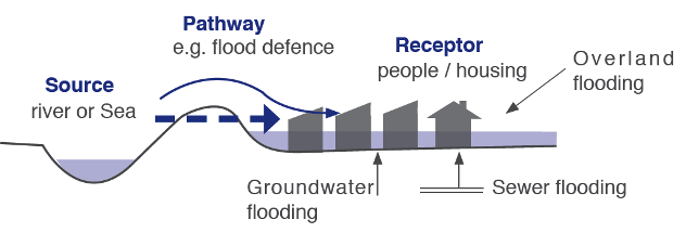
The assessment of flood risk requires an understanding of the sources, the flow path of floodwater and the people and property that can be affected. The source - pathway - receptor model, shown in Figure 9-3 illustrates this and is a widely used environmental model to assess and inform the management of risk.
Figure 9-3 Source Pathway Receptor Model
Source: Figure A1 Flood Risk Management – Guidelines for
Planning Authorities Technical Appendices.
9.11.2 Policy Context
EU Flood Directive 2007/60/EC
The Directive requires member states to carry out preliminary flood risk assessment of their river basins and coastal areas to identify areas where potential significant flood risk exists. Member states are then required to prepare flood hazard and flood risk maps for the identified areas and prepare flood risk management plans for these areas.
Catchment Flood Risk Assessment and Management Study (CFRAMS)
The National CFRAM programme commenced in 2011 and is the principle response to EU ‘Flood’ Directive (2007/60/EC) on the assessment and management of flood risk. It was transcribed into Irish law under SI No.122 of 2010. The OPW is the lead agency for flood risk management in Ireland and is the national competent authority for the EU ‘Flood’ Directive.
Detailed flood maps were published in 2014-15 and flood management plans for these areas were finalised in 2019. Within County Wexford, the CFRAM targeted areas of significant flooding (Areas for Further Assessment) included the settlements/areas of Wexford Town, New Ross Town, Gorey Town, Enniscorthy Town, Courtown, Bunclody, Blackwater, Kilmore, the South Slobs and the North Slobs. The CFRAM management plans set out the long term strategies and measures required to manage risk in these areas. Both the mapping and the plans have been incorporated into the Strategic Flood Risk Assessment that informed the preparation of the Plan (see Volume 11).
The Planning System and Flood Risk Management Guidelines
These guidelines, which were published in 2009 and subsequently amended under Circular PL2/2014, describe best flood risk practice in land use and spatial planning. The Guidelines outline that the aim of flood risk management is to minimise the level of flood risk to people, business, infrastructure and the environment through the identification and management of existing and potential future flood risks.
The guidelines identify the three key principles that should be applied when considering flood risk:
- Avoid the risk where possible.
- Substitute less vulnerable uses where avoidance is not possible.
- Mitigate and manage the risk where avoidance and substitution are not possible.
The guidelines require planning authorities to address flood risk management in their respective land use plans by preparing strategic flood risk assessments and in planning applications through site specific flood risk assessments.
9.11.3 Sources of Flood Risk in County Wexford
Fluvial
Fluvial flooding is associated with the exceedance of river channel capacity during higher flows. The process of flooding on watercourses depends on a number of characteristics associated with the catchment including; geographical location and variation in rainfall, steepness of the channel and surrounding floodplain and infiltration and runoff rates associated with urban and rural catchments. Additional flood risk may present itself at bridges and culverts where blockage can lead to a local increase in water levels and exacerbate the impacts of flooding.
Tidal and Coastal
Tidal and coastal flooding is caused by higher sea levels than normal, predominantly related to storm surges and results in the sea or tidally influenced rivers overflowing onto the land. This type of flooding is influenced by high tides and storm surges caused by low atmospheric pressure, exacerbated by high winds and wave action. With a significant length of coastline, many settlements in the County are sensitive to the impacts of tidal flooding, many in combination with fluvial flooding. Coastal communities will also be particularly vulnerable to sea level rise and increased coastal erosion.
Surface water
Flooding of land from surface water runoff is usually caused by intense rainfall that may only last a few hours. The resulting water follows natural valley lines, creating flow paths along roads and through and around developments and ponding in low spots, which often coincide with fluvial floodplains. Any areas at risk from fluvial flooding will almost certainly be at risk from surface water flooding.
Groundwater
Groundwater flooding occurs when the level of water stored in the ground rises as a result of prolonged rainfall, to meet the ground surface and flows out over it, i.e., when the capacity of this underground reservoir is exceeded. Groundwater flooding tends to be very local and results from the interaction of site-specific factors such as local geology and tidal variations. While water level may rise slowly, groundwater flooding can last for extended periods of time, and as such flooding may often result in significant damage to property and disruption.
9.11.4 Strategic Flood Risk Assessment
In accordance with the guidelines, a Strategic Flood Risk Assessment (SFRA) was prepared. The purpose of an SFRA is to provide a broad (wide area) assessment of all types of flood risk to inform strategic land-use planning decisions. The SFRA includes Stage 3 Flood Risk Assessments for the settlements of Bunclody Town and Rosslare Harbour and Kilrane as the Plan includes zoning for both of these settlements. The approach to zoning, including the application for the sequential approach and the Development Plan Justification Test, was informed by the results of those FRAs.
Future zoning in the county, including the new local area plans for Wexford Town, Enniscorthy Town and New Ross Town, will be subject to Stage 3 FRAs and the Development Plan Justification Tests before decisions on zoning are made.
The SFRA includes:
- A broad flood risk assessment of the settlements in Levels 1-5 of the settlement hierarchy
- A Stage 3 Flood Risk Assessment of Rosslare Harbour and Kilrane and Bunclody Town to inform land use zoning.
- Updated flood zone mapping to include finalised CFRAM mapping, Preliminary Flood Risk Assessment (PRFA) fluvial and coasting flood mapping and JBA Consulting fluvial flood zone mapping for the county.
- A defined approach to the assessment of climate change impacts in flood risk management.
- Policies and objectives relating to flood risk management including climate change adaptation.
9.11.5 Flood Mapping
The Council will use all available sources of information when screening for flood risk during the preparation of local area plans and when assessing development proposals. These sources include:
- The CFRAM flood zone mapping.
- The OPW National Indicative Fluvial Mapping.
- Fluvial flood zone maps prepared by JBA for the county.
- Flood zone maps prepared for flood relief schemes, e.g. Enniscorthy Town
The SFRA contains a set of flood maps for the county which incorporates some of the above. These maps are available to view on the Council’s website. The OPW National Indicative Fluvial Mapping do not form part of the SFRA.
Other flood mapping resources include: the OPW benefitting land maps, mineral alluvial soil mapping and the Ordnance Survey ‘lands liable to floods’ mapping, Geological Survey Ireland flood mapping and climate research projects such as the GWFlood project and the GWClimate project, flood studies and reports and working knowledge from local authority engineers.
9.11.6 Advice Note
Flood hazard and flood risk information is an emerging dataset of information. The flood hazard maps used by the Council may be altered in light of future data and analysis. Therefore, all landowners and developers are advised that Wexford County Council accepts no responsibility for losses or damages arising due to assessments of vulnerability to flooding of lands, uses and developments. Owners, users and developers are advised to take all reasonable measures to assess the vulnerability to flooding.
The Council will screen for flood risk based on flood maps that form part of the SFRA and any future updated versions of these maps or any other future flood maps or risk assessment information provided by the Office of Public Works, or other consultants engaged by the Council for that purpose.
The flood zone maps in the SFRA are from two different sources; JBA Consulting Engineers and Scientists and the Office of Public Works. The JBA fluvial flood zone maps for the county are based on broad-scale modelling techniques, with the exception of the fluvial flood zone maps for the area of the Rosslare Harbour and Kilrane Settlement Plan which are based on detailed modelling.
The Office of Public Works maps are divided into two sets. There are detailed flood maps for ten Areas for Further Assessment (AFA) in the county which are based on detailed modelling. The remainder of the county is covered by PFRA flood maps which are based on broad-scale modelling techniques.
The maps and the identified flood zones will require verification at an individual site level where it appears that the detailed or indicative flood zone does not match the actual conditions or the topography of the site. The onus will be on the applicant to prove beyond reasonable doubt that the subject site is not vulnerable to flooding. This must be proved based on appropriate scientific data and assessment carried out by a suitably qualified and indemnified professional in line with the requirements of the Planning System and Flood Risk Management-Guidelines for Planning Authorities (DEHLG and OPW, 2009).
9.11.7 Sequential Approach
The Guidelines recommend a sequential approach to spatial planning, promoting avoidance rather than justification and subsequent mitigation of risk. The Council will apply the sequential approach when zoning lands during the preparation of local area plans and when assessing planning applications for development in areas at risk of flooding.
The sequential approach is a key tool in ensuring that development is directed towards land that has a low risk of flooding. This approach will make use of all available information, including existing flood risk assessments, CFRAMS, flood zone maps and the classification of vulnerability of flooding of different types of development.
9.11.8 Justification Tests
The guidelines define the Justification Test as an assessment of whether a development proposal within an area at risk of flooding meets specific criteria for proper planning and sustainable development and demonstrates that it will not be subject to unacceptable risk nor increase flood risk elsewhere. The Justification Test should be applied only where development is within flood risk areas that would be defined as inappropriate under the screening test of the sequential risk based approach25 . Inappropriate development that does not meet the criteria of the development plan Justification Test should not be considered at the plan-making stage or the development management Justification Test should not be approved within the development management process.
9.11.9 Riparian Zones and Flood Risk Management
River corridors and their associated riparian zones are important for flood risk management and water protection. The riparian zone needs to be considered as an integrated part of a river, and any unnecessary interference with this zone can be damaging to flood attenuation and flood management features of the zone. The Planning Authority will have regard to the guidelines set out in the document ‘Planning for Watercourses in the Urban Environment (Inland Fisheries Ireland 2020)' when considering development proposals in the vicinity of rivers and streams. The design, layout and functions of the riparian zone is also discussed in detail in Chapter 11 Landscape and Green Infrastructure and this should be consulted when designing schemes adjoining watercourses, including public open spaces, recreational areas and activities and the location of dwellings and private gardens.
9.11.10 Development Management
The SFRA provides further detail of the application of the sequential approach, flood zones, climate change, vulnerability of developments, the requirements for site-specific flood risk assessment, the development management justification test, mitigation and residual risk.
Flood Risk Management Objectives
It is the objective of the Council:
Objective FRM01
Objective FRM02
Objective FRM03
Objective FRM04
Objective FRM05
Objective FRM06
Objective FRM07
Objective FRM08
Objective FRM09
Objective FRM10
Objective FRM11
Objective FRM12
To protect the integrity of any formal (OPW or Wexford County Council) flood risk management infrastructure thereby ensuring that any development does not negatively impact any existing defence infrastructure or compromise any proposed new infrastructure.
Objective FRM13
Objective FRM14
Objective FRM15
Objective FRM16
Objective FRM17
Objectives FRM18
Objective FRM19
9.11.11 Surface Water Management
The management of surface water is important so as to avoid increased flood or pollution risk in the storm water network, rivers and streams in the county’s towns, villages and rural areas. In this regard, the Council will require compliance with best practice guidance for the collection, reuse, treatment and disposal of surface water for all future development proposals.
Traditionally, rain falling on impervious surfaces was directed into a receiving watercourse through surface water drainage systems. While such drainage systems are effective at transferring surface water quickly, they provide only limited attenuation causing the volume of water in the receiving watercourse to increase more rapidly, thereby increasing flood risk.
Sustainable Drainage Systems, commonly known as SuDS, is an approach that seeks to manage surface water as close as possible to its origin by various nature-based or engineering solutions that replicate natural drainage processes, before it enters the watercourse. Nature based solutions can be equally or more effective, better for biodiversity, the environment and in terms of visual amenity.
SuDS and nature-based solutions provide an integrated approach which provides many benefits including:
- Water quantity by controlling the quantity of run-off to support the management of flood risk, and maintain and protect the natural water cycle;
- Improving water quality by managing the quality of the runoff to prevent pollution;
- Amenity by creating and sustaining better places for people;
- Biodiversity by creating and sustaining better places for nature, and
- Climate adaptation and mitigation such as building resilience, micro-cooling and carbon sequestration.
The application of SuDS techniques and nature-based solutions allows surface water to be either infiltrated or conveyed more slowly to water courses using porous surface treatments such as bioretention areas, ponds, swales, basins, rain gardens, wetlands, filter drain, green roofs or other installations. This approach is often less expensive to construct and easier to maintain than underground solutions, whilst providing the multiple additional benefits previously outlined.
The Council will require the application of SuDS and nature-based solutions in new development proposals and proposals to extend an existing development. While traditionally, the application of SuDS techniques is site-specific and depends on the site’s characteristics, the Council will work with designers and developers to deliver an integrated and area-based approach where possible so that the approach works like a mini-catchment.
Applicants will also be required to demonstrate that climate change considerations have been incorporated into the design and the role of green infrastructure in providing nature-based solutions must also be demonstrated. All applications should include a commensurate drainage assessment which outlines the drainage design considerations/strategy in line with the flood risk, surface water management and climate change requirements and objectives in the Plan.
Surface Water Management Objectives
It is the objective of the Council:
Objective SWM01
Objective SWM02
Objective SWM03
Objective SWM04
Objective SWM05
Objective SWM06
Objective SWM07
Objective SWM08
To incorporate an integrated area based approach to SuDS and nature-based solutions and green infrastructure in the preparation of future local area plans.
9.12 Power Transmission
The Council will support the reinforcement of the electricity transmission grid to improve energy supply to the county. Where strategic route corridors have been identified, the Council will support the statutory providers of national grid infrastructure by safeguarding such corridors from encroachment by other developments that might compromise the provision of energy networks, provided these corridors do not have adverse impacts on residential amenity or the environment. Where proposed high voltage lines traverse existing or proposed residential areas they should be located underground where appropriate, in the interest of residential amenity
The Council will encourage the undergrounding of the network in sensitive locations. The Council will also seek the removal of overhead power cables within all urban areas.
Power Transmission Objectives
It is the objective of the Council:
Objective PT01
To facilitate the provision of and improvements to energy networks in principle, provided that it can be demonstrated that:
- The development is required in order to facilitate the provision or retention of significant economic or social infrastructure.
- The route proposed has been identified with due consideration for social, environmental and cultural impacts.
- The design is such that will achieve least environmental impact consistent with not incurring excessive cost.
- Where impacts are inevitable mitigation features have been included.
- Proposals for energy infrastructure should be assessed in accordance with the requirements of Article 6 of the Habitats Directive.
Objective PT02
Objective PT03
To support the upgrading of existing electricity networks and the reuse of existing power line routes.
Objective PT04
Objective PT05
To support the removal and undergrounding of overhead power lines in urban areas.
9.13 Gas Network
Currently the County is connected to the national gas network at Great Island with parts of Wexford Town connected to the system. Expansion to the remaining three main towns would be considered positively by the Council particularly when serving industrial uses with high energy demands.
Gas Network Objective
It is the objective of the Council:
Objective GN01
To support the extension of the gas network throughout County Wexford, subject to compliance with normal planning and environmental criteria.
Objective GN02
To promote renewable gas leading to carbon emission reduction in agriculture, industry, heating and transport as well as sustainable local employment opportunities and support the transition of the gas network to a “carbon neutral” gas network by 2050.
- 1- Mandatory objective 2(b) of Section 10 of the Planning and Development Act, 2000 (as amended).
- 2- The projects and programmes listed are expected to be either commenced, progressed or completed during the 2020-2024 period. This list is continuously being refined and is subject to budget, technical and environmental constraints, as well as statutory approvals.
- 3- Ireland’s Environment-An Assessment 2016, EPA, 2016, page 133.
- 4- This settlement is served by the Wexford Town Wastewater Treatment Plant.
- 5- This settlement is served by the Gorey Town Wastewater Treatment Plant
- 6- This settlement is served by the Wexford Town Wastewater Treatment Plant.
- 7- This settlement is served by the Wexford Town Wastewater Treatment Plant.
- 8- There is no public wastewater treatment plant in Craanford
- 9 This settlement is served by the Wexford Town Wastewater Treatment Plant
- 10-This settlement is served by the Wexford Town Wastewater Treatment Plant
- 11- There is no public wastewater treatment plant in Ramsgrange.
- 12-The projects and programmes listed are expected to be either commenced, progressed or completed during the 2020-2024 period. This list is continuously being refined and is subject to budget, technical and environmental constraints, as well as statutory approvals.
- 13-See Chapter 10 Environmental Management for further details on the Blue Dot Programme/Pristine Waters.
- 14- https://www.epa.ie/mobile/irelandsenvironment/susta;inableeconomy/
- 15- Ireland’s Environment-An Assessment, EPA, 2016 page 95.
- 16- Anaerobic digestion is a biological sludge treatment process during which microorganisms break down biodegradable material in the absence of oxygen producing a stable sludge product and biogas which is combusted to generate heat and electricity.
- 17- Composting is the mixing of Nitrogen rich (sludge) and Carbon rich (wood chippings, straw etc) to ensure that predetermined quality targets are met.
- 18- Alkaline stabilisation is the treatment of sludge by the addition of an alkaline product, usually lime, to raise the pH of the sludge to ensure predetermined quality targets are met.
- 19-Biosolids are wastewater solids that have been treated to an approved standard using treatment processes such as advanced digestion, composting, thermal drying or lime stabilisation and are suitable for use in agriculture.
- 20- Satellite dewatering sites act as ‘intermediate centres’ at which liquid sludge is dewatered, that is, water is eliminated from sludge using mechanical dewatering to reduce sludge volume to reduce the number of traffic movements and the cost of sludge transportation. These sites are typically located at medium to large wastewater treatment plants.
- 21- A Sludge Hub Centre is a centralised regional sludge treatment facility which provides for treatment of wastewater sludge to produce biosolids and is typically located at large wastewater treatments plants.
- 22 Thermal drying is undertaken by direct or indirect application of an external heat source to evaporate water from the sludge
- 23http://www.epa.ie/irelandsenvironment/waste/
- 24https://www.dccae.gov.ie/documents/NBP_MAP_COUNTY__Wexford.pdf (viewed 3rd April 2020).
- 25The Planning System and Flood Risk Management – Guidelines for Planning Authorities (DEHLG and OPW, 2009), p.60.