Section 6 Transport and Mobility
6.1 Urban Route Concept and Structure
The Design Manual for Urban Roads and Streets recognises the different ‘movement functions’ or roles which particular routes play and sets out a hierarchy of route types and characteristics. It identifies three route types: Arterial, Link and Local Routes.
Chapter 5 Design and Place-making in Towns and Villages details the crucial role of network and route design in the urban structure and place quality in our County’s towns and villages. Route type will inform the design of the street, which forms the most significant part of the public realm of our towns and villages. Route type therefore will also inform and guide building lines, quality, landscaping, building type and density, landscape and land use.
The road design guidelines set out in Section 6.1.1, 6.1.2 and 6.1.3 provide design guidance for each road typology in the hierarchy of routes. Guidance is also provided on a Wexford County Council derivation - Country Roads which are typically rural in character at the town or village fringe where they protect and enhance their landscape character and biodiversity function and provide for new and improved pedestrian and cycle facilities.
DMURS provides detailed guidance on the detailed design of radii, carriageway width, surfaces, junction design, visibility and splays, alignment and curvature and deflections and parking. The planning and design of all streets and roads in the plan area should comply with the objectives and guidelines included in DMURS.
6.1.1 Arterial Routes3
Arterial Routes are the main streets and roads and are the highest level routes within the street and road hierarchy of towns and villages. This typology is diverse as it includes existing routes and planned new routes.
Arterial routes are the major strategic routes that connect major centres and nodes. They may also include orbital routes. Pedestrians, cyclists and public transport should be prioritised on these routes but they may also need to convey a volume of individual traffic movements. The routes have a higher design speed and greater width.
On new routes a more consistent and integrated approach to design will be required. On existing routes, more bespoke approaches will be needed to take account of existing constraints and opportunities.
Indicative sections and plans for this road type are illustrated in Figure 6-1. DMURS provides guidance on the detailed design of radii, carriageway width, surfaces, visibility and splays, alignment, curvature and deflections and parking. In particular, careful consideration must be given to junction design. All junctions must meet DMURS standards and there will be a presumption against roundabouts and in favour of standard junctions (either signalised, priority or uncontrolled).
Existing large-scale roundabouts should be retrofitted or replaced by standard junctions along the existing main routes in the towns and villages, to achieve better provision for cyclists and pedestrians and to provide for the redevelopment of key corner locations.
6.1.2 Link Routes
These routes are at the second level in the hierarchy and they provide links to Arterial routes, or between centres, neighbourhoods or suburbs. The movement function of Link routes will be significant but they will have a lesser volume of traffic with a destination outside the town. They cater for shorter journeys and the design, width and design speed is lower.
Like Arterial routes, through traffic will be attracted to Link routes where trips are more direct and are designed to cater for more moderate speeds (i.e. up to 50km/h). For this reason, public transport provision should also focus on Link routes.
These routes can accommodate building height which shall be proportionate to the road width to ensure appropriate enclosure. There should be particular attention to the different characteristics of the areas through which they pass. A higher standard of design will be expected in places with more important ‘place’ function. Some access may also be allowed to frontage along Link routes.
Indicative sections and plans for this road type are illustrated in Figure 6-2. DMURS provides guidance on the detailed design of radii, carriageway width, surfaces, visibility and splays, alignment, curvature and deflections and parking on Link routes. In particular, careful consideration must be given to junction design. There will be a presumption against roundabouts on Link routes in favour of standard junctions (signalised, priority or uncontrolled).
As with Arterial routes, existing large-scale roundabouts on Link routes should be retrofitted or replaced by standard junctions so as to achieve better provision for cyclists and pedestrians and to provide for the redevelopment of key corner locations and a sense of enclosure.
6.1.3 Local Streets and Roads
Local streets and roads are the most common and lowest level of route in the hierarchy of routes. Although important from an access point of view, they generally (although not always) carry low levels of traffic. They are particularly important as places in their own right, often acting as social spaces for interaction, children’s play, recreation, business and other activities. Rear access lanes in town and village centres provide important local level connections and should be upgraded and utilised where possible.
A more consistent and integrated approach to design will be required on new local streets and roads. On existing local routes more bespoke approaches will be needed to take account of existing constraints and opportunities, particularly where retrofitting is appropriate to calm traffic or achieve new local connections.
Uncontrolled junctions (cross-roads) may be suitable for many junctions in new residential areas.
Careful design will be required to balance the access and place functions of local streets and roads. Indicative sections and plans for this road type are included in Figure 6-3. DMURS provides guidance on the detailed design of local streets and roads. Measures should focus on managing traffic speeds and optimising safety measures within a high quality urban context. It will be very important to combine smaller dimensions in street design with smaller scale urban design for building scale and setback. Junction size and design should emphasis pedestrian and cyclist needs and priority.
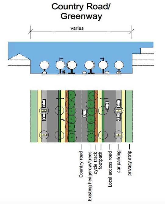
6.1.4 Country Roads/Green Routes
Country roads provide important radial connections from the surrounding and suburban areas to the town and village centres. They are also important access routes for many existing developments. The routes are typically rural in character at the town fringe, but have been altered and provided with a variety of new boundary types, set-backs and splays. Pedestrian facilities are intermittent in places.
The overall approach will be to bring greater coherence to the protection and enhancement of the country roads as green routes by retaining as much of their landscape character and biodiversity function and providing for new and improved pedestrian and cycle facilities. Approaches will need to be bespoke given the individual character and the characteristics of existing country roads. Green routes will transition to more urban character and configurations as they approach town and village centres, however, their essential functions will be consistent.
Careful design of the country roads/green routes will be required to achieve good movement characteristics, along with active frontage. Indicative sections and plans for this road type are included in Figure 6-4.
The emphasis, where possible, should be on improving rather than significantly realigning or widening the existing country road. Additional pedestrian and cycle facilities should be provided behind the retained hedgerow and tree line. Visibility and splay distances at new junctions must be carefully considered to minimise the impact on the existing hedgerow and tree line.
Figure 6-1 Indicative Arterial Route

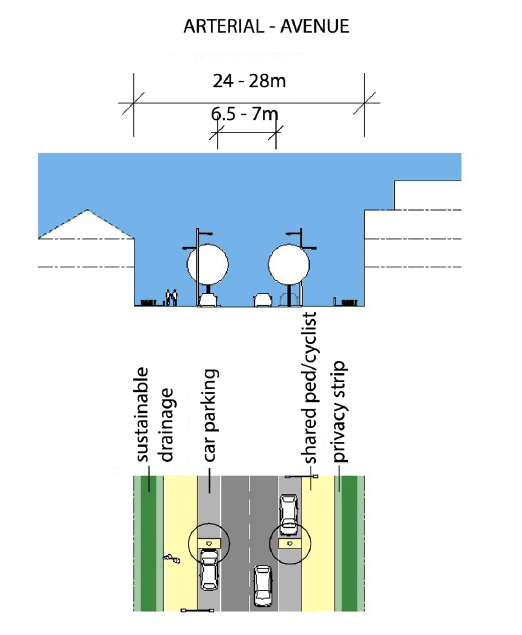
Figure 6-2 Indicative Link Route
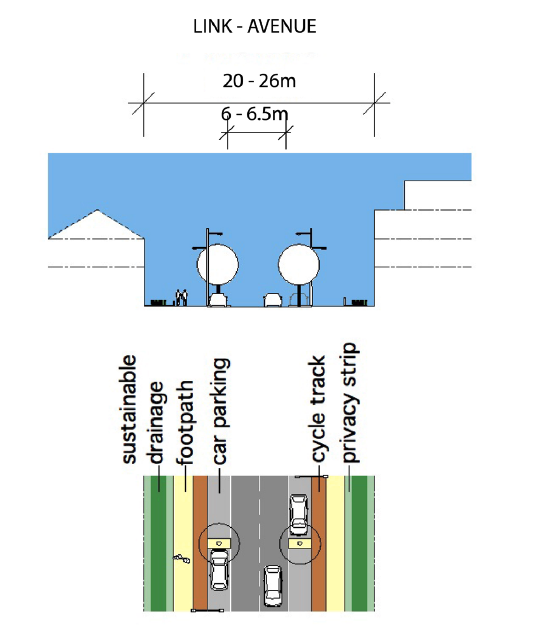

Figure 6-3 Indicative Local Streets and Roads Layout
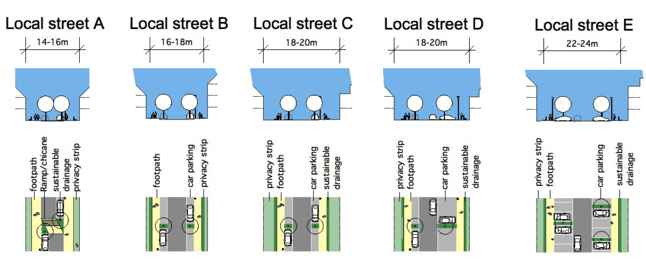

Figure 6-4 Indicative Country Road/Green Route Layout
6.2 Assessment of Road Traffic Safety
All developments with potential impacts on public roads will be assessed on their merits having regard to the following issues:
- The protection and promotion of public safety.
- The avoidance of unnecessary congestion and obstruction on the roads network.
- Safeguarding the function, carrying capacity, structural stability, and investment in the roads network.
6.2.1 Traffic and Transport Assessment
The Planning Authority will ensure that a Traffic and Transport Assessment (TTA) is carried out for all categories of roads where a development listed in Table 6-1 is proposed.
A TTA will be required for all development on National Roads where a development reaches a threshold identified in Table 6-2. TTA may also be required for developments which are sub-threshold but which the Planning Authority or TII consider may have a negative impact. In such cases the Planning Authority will use the criteria in Table 6-3 to assess whether a TTA must be submitted.
As well as the general requirement for TTA for all roads under Table 6-1 and Table 6-2, in certain instances TTA may be required on Regional or Local roads using the criteria in Table 6-3. This will be reviewed on a case-by-case basis.
Table 6-1 Mandatory Thresholds for Traffic and Transport Assessments
|
Traffic to and from the development exceeds 10% of the traffic flow on the adjoining road |
|
Traffic to and from the development exceeds 5% of the traffic flow on the adjoining road where congestion exists or the location is sensitive* |
|
Residential development in excess of 200 dwellings |
|
Retail and leisure development in excess of 1,000 m2 |
|
Office, education and hospital development in excess of 2,500 m2 |
|
Industrial development in excess of 5,000 m2 |
|
Distribution and warehousing in excess of 10,000 m2 |
*In locations that experience particularly heavy congestion and when traffic flows from a proposed development are less than 5% of the traffic flows on the adjoining road, a TTA may still be required. When in doubt, the requirement for a TTA should always be scoped with the local authority
Table 6-2 Advisory Thresholds for Traffic and Transport Assessments-National Roads
|
Vehicle Movements |
100 trips in/out combined in the peak hours for the proposed development |
|
|
Development traffic exceeds 10% of turning movements at junctions with and on National Roads |
||
|
Development traffic exceeds 5% of turning movements at junctions with National Roads if location has potential to become congested or sensitive |
||
|
Size
|
Retail |
1,000 m2 gross floor area |
|
Leisure facilities including hotels, conference centres and cinemas |
1,000 m2 gross floor area |
|
|
Business |
2,500 m2 gross floor area |
|
|
Industry |
5,000 m2 gross floor area |
|
|
Distribution and Warehousing |
10,000 m2 gross floor area |
|
|
Hospitals and education facilities |
2,500 m2 gross floor area |
|
|
Stadia |
1,500 person capacity |
|
|
Community facilities including places of worship, community centres |
1,000 m2 gross floor area |
|
|
Housing |
50 dwellings within urban areas with a population of less than 30,000. 100 dwellings within urban areas with a population equal to or greater than 30,000. |
|
|
Parking |
100 on-site parking spaces |
|
Table 6-3 Sub-Threshold Criteria for Traffic and Transport Assessments
|
Vehicle Movements |
The character and total number of trips in/out combined per day are such so as to cause concern. |
|
Location |
The site is not consistent with national guidance or local plan policy or accessibility criteria in the County Development Plan. |
|
Other Considerations |
The development is part of incremental development that will have significant transport implications. |
|
The development may generate traffic at peak times in a heavily trafficked/congested area near a junction with a main traffic route. |
|
|
The development may generate traffic, particularly heavy vehicles in a residential area. |
|
|
There are concerns over the development’s potential effects on road safety. |
|
|
The development is in a tourist area with potential to cause congestion. |
|
|
The Planning Authority considers that the proposal will result in a material change in trip patterns or raises other significant transport implications. |
6.2.2 Road Safety Audits
Road Safety Audits (RSA) will be required on National Roads in accordance with the requirements of the TII Publication Road Safety Audit (GE-STY-01024) and for projects of a similar nature. Appendix A provides a representative sample of types of Schemes and guidance on the requirement for an Audit for each type of Scheme, and also on the relevant Audit Stages to be carried out if an Audit is required.
An RSA will also be required in all cases where a TTA has been requested on national and non-national roads and may be requested in other cases on non-national roads (the standards of GE-STY-01024 apply).
6.2.3 Road Safety Impact Assessment
Road Safety Impact Assessment (RSIA) shall be carried out in accordance with the TII publication PE-PMG-02001 (December 2017). RSIA is required only where the anticipated effect on the national network is substantial. Smaller projects will not require assessment.
RSIA shall be done for:
- Any major new road project.
- Road realignment of which a continuous section is greater than 2km.
Projects which do not meet the above criteria may also benefit from RSIA. If there is any doubt the Safety (Roads and Tunnels) section of TII will be consulted in order to determine the requirement for RSIA for each specific scheme.
6.2.4 Workplace Travel Plans
A Workplace Travel Plan or Mobility Management Plan outlines a series of measures to encourage sustainable travel modes and reduce car borne traffic within a development. Workplace Travel Plans are required for larger sized developments as defined in Table 6-4 in accordance with the Achieving Effective Workplace Travel Plans – Guidance for Local Authorities published by the National Transport Agency (NTA).
Workplace Travel Plans are required for all new schools or for existing schools where 25% or greater expansion in classrooms is proposed.
Table 6-4 Thresholds for the Submission of a Workplace Travel Plan
|
Land use |
Workplace Travel Plan Statement |
Indicative number of jobs |
Standardised Workplace Travel Plan |
Indicative number of jobs |
|
Offices/ Financial |
>500 m2 |
25-100 |
>2,000 m2 |
>100 |
|
Retails/ Shops |
>600 m2 |
25-100 |
>2,500 m2 |
>100 |
|
Industrial |
>2,500 m2 |
25-100 |
>6,000 m2 |
>100 |
|
Leisure |
|
25-100 |
|
>100 or >100,000 visitors per annum |
|
Hospitals/ Medical Centres |
|
25-100 |
|
>100 or >100,000 visitors per annum |
|
Warehousing |
>2,500 m2 |
25-100 |
>10,000 m2 |
>100 |
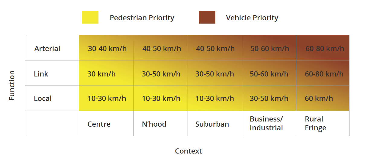
6.2.5 Design Speed
Table 6.5 which is derived from DMURS illustrates the broader application of design speeds according to context and function. Designers should refer to this table when designing urban streets and roads to align speed limits, design speeds and road function. When applying these limits designers must also consider how effectively they can be implemented, as the introduction of more moderate and/or lower speed limits out of context and/or without associated speed reduction measures may not succeed.
Table 6-5 Design Speed Selection Matrix

6.2.6 Siting and Design of Access/Egress Points
The Planning Authority will only permit the formation of a new, or the material intensification of use of an existing, vehicular access/egress to a public road (including to/from a private laneway) where it has been demonstrated that:
- The principle of a new/intensified access point to/from that category of road satisfies the criteria for such as set out in the Roads section of Volume 1 Chapter 8 Transportation Strategy.
- The detailed siting and design of the access/egress point is acceptable having regard to:
- The characteristics and features of the public road and private lane at that location;
- The availability of the required sightlines at the access/egress point to the public road, to allow for safe intervisibility of vehicles, cyclists, motorcyclists and pedestrians;
- The design and construction of the access/egress point;
- Surface water management arrangements;
- Impacts on existing mature trees and existing built features such as stone walls at the road frontage.
It should be noted that the Planning Authority will assess each application for a proposed new or the material intensification of an existing, access/egress point on its particular merits and will have regard to relevant TII Guidelines (including Rural Road Link Design and Geometric Design of Junctions, as may be updated) in that assessment.
A. Characteristics and Features of the Public Road and Private Laneway
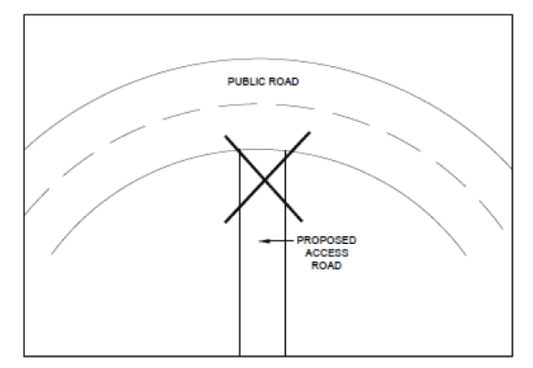
The Planning Authority will assess the width, condition and horizontal and vertical alignment of the public road to determine if it is suitable in respect of its safety and capacity for a proposed new, or the material intensification of an existing, access /egress point at the proposed location. New or material intensified access/egress points on the inside of sharper bends on roads with higher traffic levels and/or higher general speeds will generally be discouraged as indicated on Figure 6-5 below.
Figure 6-5 Junction located on the inside of a sharp curve
The Planning Authority will discourage the provision of new, or the material intensification of existing, access/egress points in locations where there is potential for public safety hazards arising from its close proximity to existing junctions, an existing multiplicity of existing access/egress points, pedestrian crossing points and/or other traffic calming features (existing or proposed).
The Planning Authority will consider if the proposed new or the material intensification of an existing access/egress point would represent a public safety improvement over an existing access/egress point which would be closed on formation of the new access/egress point.
In towns and villages, where there is no existing footpath at the road edge, the design and position of the access/egress point and frontage of the site shall facilitate the possible future construction of a footpath.
For proposed development on private laneways, the Planning Authority will consider:
- The availability of passing places on the laneway;
- The condition and alignment of the laneway which should be of a suitable standard to facilitate ease of access to the site, including by emergency service vehicles.
- Evidence that the applicant has the legal right to use the private lane as an access/egress to/from the proposed development.
B. Sightlines
Road speed limit of less than 60 kph
The Planning Authority will have regard to the principles, approaches and standards of DMURS in the assessment of appropriate sight distances where a new or materially intensified access/egress point is proposed to a public road where a speed limit of less than 60 kph applies.
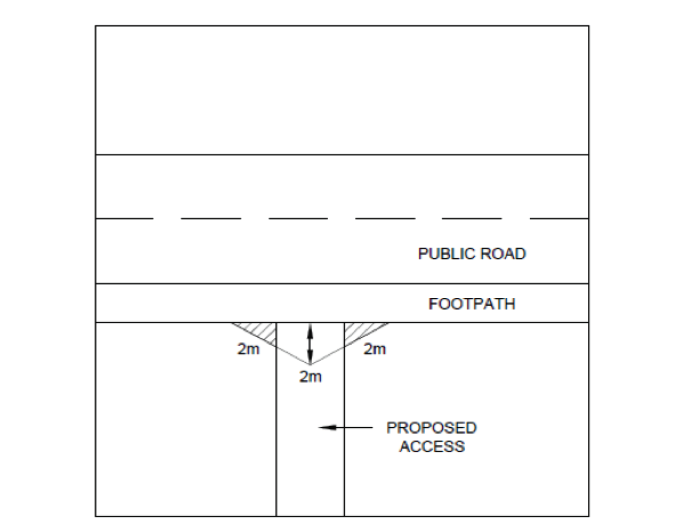
Where the proposed access/egress point crosses an existing or potential future footpath (generally in towns and villages) the access/egress point shall be designed to facilitate visibility of and by pedestrians, and other road users. This may require limits on the height of boundary walls/fences and/or landscaping where the boundary treatment directly adjoins an existing or potential future footpath as detailed on Figure 6-6 below. This requirement is in addition to vehicle intervisibility sightline considerations.
 Figure 6-6 Visibility at Back of Footpath Crossing
Road speed limit greater than 60 kph
Where the proposed new or materially intensified access/egress point is to a road with a speed limit of greater than 60 kph, it should be demonstrated that the following sightline requirements can be achieved:
- National Roads 230m
- Class 1 Regional Roads 220m
- Class 2 Regional Roads 135m
- Local /County Roads 65m
Table 6-6 sets out the sightline requirements for Class 1 and Class 2 regional roads.
Table 6-6 Class 1 and Class 2 Regional Roads
|
Class 1 Regional Roads |
Class 2 Regional Roads |
|---|---|
|
|
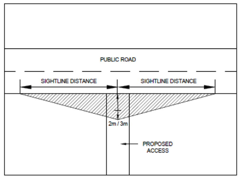
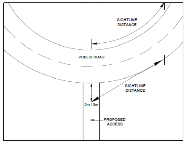
Sightlines shall be measured from a point 3 metres back from the edge of the public road (2 metres in the case of a proposed access/egress to be used for a single dwelling house), at the centre point of the proposed access/egress to points generally on the near side of the public road in both directions (see Figure 6-7 below).
Figure 6-7 Measuring Sightlines
Where the access/egress point would be on the outside of a bend, sightlines will be measured on to the far side of the road also (Figure 6-8 below).
Figure 6-8 Visibility Standards with a Curved Major Road

The formation of sightlines to all new or materially intensified access/egress points
The provision of sightlines must comply with the relevant objectives in Chapter 8 Transportation Strategy. The required sightlines shall be formed prior to first use (including by construction traffic) of the new or materially intensified access / egress point to the satisfaction of the Planning Authority, and retained thereafter in perpetuity. Nothing shall be constructed or allowed to grow within the sightline envelope to a height which would obstruct sightlines.
Development on Private Laneways
All of the above requirements for the provision of safe sightlines, including those relating to ownership of land on which works are required to form sightlines, will also be applied to proposed development on a private laneway where the private laneway meets the public road and where the access to the site meets the private lane.
C. Design and Construction of Access / Egress point
The access/egress point shall have suitable splays, generally to 45 degrees, to facilitate safe access and egress. Walls and gateposts at/adjacent to the access/egress point shall be such as not to obstruct sightlines. Gates shall be positioned to facilitate safe parking whilst the gate is being opened and closed.
The gradient of the access drive shall not exceed 3% for the first 7m adjacent to the carriageway of the public road and the carriage of the public road is not raised, lowered or otherwise altered where the proposed access meets it.
The access/egress point shall be constructed to a standard such that no mud, stones dust etc. is brought from the site onto the public road.
D. Surface Water Management
It shall be demonstrated, using the principles of Sustainable Drainage Systems, that the proposed new/intensified access/egress point would not result in surface water being brought onto the public road and that existing roadside drainage would not be adversely affected.
E. Impacts on Existing Mature Trees and Existing Built Features at the Road Frontage
It shall be demonstrated that the formation of the access/egress point and its required sightline arrangements would not result in the undue loss of mature trees, or built features such as stone walls and piers, where such natural or built features contribute significantly to the amenity and character of the area. Alternative safe access/egress points should be sought if such a significant undue loss is likely. If the Planning Authority considers that the loss of such features is acceptable, replacement/relocated landscaping or built features shall be provided on land which is demonstrated to be in the ownership of the applicant.
6.2.7 New or widened vehicular parking area on the frontage of existing development
Where a new or widened access/egress point is proposed to facilitate the provision of a new or widened parking area on the frontage of an existing development, the Planning Authority will also have regard to the following:
- Existing road conditions, including an assessment of whether on-street parking gives rise to safety hazards and/or undue obstruction of other road users.
- The potential impact of the new/widened access, boundary treatment removal and new/enlarged hard standing area on the visual amenities of the area and on surface water drainage.
- The degree to which the proposal would establish a precedent for similar development in the vicinity and an assessment of the cumulative impacts which may be generated from further similar development.
Stopping Sight Distances
Guidance for both stopping distances and visibility splays at junctions and accesses in rural areas is set out in the Design Manual for Roads and Bridges. Guidance on both stopping distances and visibility splays at junctions and accesses in urban areas is set out in Chapter 4 of DMURS. In summary, the Planning Authority considers that the design of streets in urban areas should determine vehicular speeds and that lower vehicular speeds should be encouraged in all cases (See Chapter 5 Design and Place-making in Towns and Villages for further guidance).
6.2.8 Road Re-Instatement
Any damage to public roads occurring as a result of a development shall be repaired to the satisfaction of the Local Authority, and where deemed necessary, a cash security may be required to guarantee the satisfactory repair of damage.
In certain circumstances the road network may be deficient in carrying capacity and it may be appropriate to facilitate the development subject to a requirement that road strengthening works be undertaken by the Local Authority at the expense of the developer. In such circumstances a development contribution shall be levied or in appropriate circumstances a condition may be imposed requiring works to be undertaken by the developer to Council specifications, including indemnification of the Council.
6.3 Car Parking
6.3.1 Car Parking Standards
The Planning Authority will require car parking to be provided at the rates set out in Table 6.7. The number of parking spaces to be designated for people with disabilities will depend on the building type as detailed in Table 6.8. Each car parking space shall be clearly marked and delineated. As a measure to tackle urban decline and promote investment into the town and village centres reduced parking standards shall apply. Where parking cannot be accommodated in the urban areas a planning contribution may be required. The development of the central urban areas will ensure that existing public infrastructure is maximised.
Table 6-7 Car Parking Standards
|
Type of Development |
Maximum Standard |
Maximum Standard in Town Centre or Village Centre |
|---|---|---|
|
Residential |
||
|
House |
2 per house |
0 |
|
Apartment |
1 per apartment |
0 |
|
Hotel |
1 space per bedroom plus 1 space per 25m2 of function room/ bar/ restaurant/ meeting room space |
1 space per 3 bedrooms 1 space per 50m2 of function room or conference room |
|
Guest House/B&B/hostel |
1 space per bedroom or 1 space per 10 bed dormitory |
1 space per 3 bedrooms 1 space per 100m2 of function room or conference room |
|
Caravan/Camping/Glamping Site |
1 space per pitch |
N/A |
|
Commercial |
||
|
Shopping: general retail floor space (open to the public) |
1 space per 20m2 |
1 space per 100m2 |
|
Offices: gross floor space |
1 space per 25m2 |
1 space per 100m2 |
|
Public houses/ function rooms/ restaurants |
1 space per 25m2 |
1 space per 100m2 |
|
Hot Food Takeaways |
5 spaces |
5 spaces |
|
Cinemas, theatres, stadia |
1 space per 3 seats |
1 space per 100m2 |
|
Conference centres: Public Areas |
1 space per 25m2 |
1 space per 100m2 |
|
Churches/ Church hall |
1 space per 10 seats |
1 space per 100m2 |
|
Nursing homes |
1.5 spaces per bed |
1 space per 3 beds |
|
Other medical |
3 spaces per consultants room |
1 space per consultants room |
|
Manufacturing light industry |
1 space per 50m2 (gross floorspace) |
1 space per 50m2 |
|
Industry General |
1 space per 50m2 |
1 space per 50m2 |
|
Car showrooms |
1 space per 50m2 |
1 space per 50m2 |
|
Car repair business |
1 space per 25m2 |
1 space per 25m2 |
|
Warehouse: Gross floorspace |
1 space per 100m2 |
1 space per 50m2 |
|
Community |
||
|
Sports clubs and grounds, swimming pools |
1 space per 15m2. 6 spaces for each pitch, 2 spaces for each court |
1 space per 100m2 |
|
Funeral home |
15 spaces |
5 |
|
School |
1.5 spaces per classroom |
0 |
|
Crèche/Childcare |
1 space per 4 children plus 1 space per employee |
1 space per 10 children and 1 space per employee. |
|
Note:
Where the provision of on-site parking is not possible or desirable for design reasons, the Council may, where appropriate, consider the payment of a financial contribution towards the provision of car parking nearby. |
||
Table 6-8 Accessible Car Parking Standards
|
Building Type |
Car parking requirement |
|---|---|
|
Buildings not normally visited by the public |
At least 5% of the total number of spaces with a minimum provision of at least one such space. |
|
Shops and other buildings to which the public has access |
Minimum one space of appropriate dimensions in the first 25 standard spaces; minimum three in 25–50 standard spaces; minimum five in 50–100 standard spaces; and an additional three per every 100 standard spaces in excess thereof. |
|
Premises used by a high proportion of people with disabilities will require a larger than average number of designated spaces. |
The parking requirement for such building types should be calculated in relation to the anticipated demand. |
6.3.2 Location of New Car Parks
The location of car parks will require detailed consideration. Parking areas in the wrong location can add to congestion in the town centres which results in pedestrian conflict, increased pollution and reduced functionality in the public transport system. In town centres surface level car parking is an extremely poor use of valuable public infrastructure and can sometimes, due to the income stream from charges, be an impediment to the redevelopment of the sites in which they are located.
Parking areas within town centres will be required for those who have mobility issues but in general large parking areas must be located on the edge of the centre and, if possible adjacent to public transport routes with good pedestrian and cycle facilities nearby.
The location of urban car parks shall be identified in the Local Area Plans for the four main towns in the county.
6.3.3 Car Parking Design and Layout
The following should be considered when designing car parking areas:
- Parking and services should be located with regard to the safety and security of all and the amenities of adjoining properties.
- The location of parking and service spaces should have regard to ensuring the security of all users and the amenities of adjoining properties.
- Parking is provided communally to maximise efficiency and accommodate visitors without the need to provide additional dedicated services.
- Large, unbroken areas of hard standing for parking and servicing should be avoided; hard and soft landscaping should be used to break up and/or screen such areas.
- Access, parking and servicing areas should be designed to allow for safe and direct pedestrian and cycle access to and from the entrance to the development from the car park and the public road and footpath. This can be achieved, if necessary, by segregated and/or demarcated pedestrian/cycle routes.
- In addition to the general car parking standards, space will be required to be included in the development design for vehicles involved in the operation of business including the delivery and collection of goods, the carrying out of repairs and maintenance.
- Safe, secure and convenient spaces for motorcycle parking should be provided within large parking areas. Parking areas shall provide bike racks that can accommodate parking for bikes at the rate of 20% of the cars that are accommodated in the car parking area (e.g. if car park is proposed for 100 car parking spaces then 20 bicycle parking spaces must be provided).
- Schools, crèches, recreational facilities and other such facilities will be required to make provision for adequate and safe vehicular drop off facilities, in addition to the car parking requirements. Developments with large parking areas should be designed to facilitate safe and convenient pick up and collection of visitors, including by taxi.
- Electric vehicle charging points must be provided on 20% of the parking spaces and the remainder of the spaces must have the necessary infrastructure installed to enable the future provision of charging points.
6.3.4 Dimensions of Parking Spaces and Loading Bays
The required dimensions for parking and loading bays are set out in Table 6-9 and should be incorporated into the design of developments.
Table 6-9 Dimensions of Parking Spaces and Loading Bays
|
Type of space |
Dimension |
|---|---|
|
Parallel parking to kerb |
6.0m x 2.4m |
|
Perpendicular parking (not including minimum 0.3m footpath overhang). Use only on roads with low traffic volumes and speeds |
5.0m x 2.4m |
|
Angled parking. On wider roads or one-way streets, parking spaces can be angled according to the available road width. |
4.2m x 2.4m for 60̊ angle 3.6m x 2.4m for 45̊ angle |
|
Disabled parking bay including transfer hatching to side and rear |
6.0m x 3.7m |
|
Loading bay for vans (facilities for larger vehicles should be off street) |
6.0m x 2.8m |
|
Circulation Aisles |
6.0m in width |
Note: The dimensions do not include the hatch marking around the spaces of standard 50mm.
6.3.5 Electric Vehicle Charging Points
The ESB is responsible for the roll out of electric car charge points in Ireland. There are three charging point options available: home charge points, public charge points (in places such as on-street and shopping centre car parks) and fast charge points (along inter-urban transport routes). The Planning Authority will facilitate and encourage the provision of charge point infrastructure, to achieve a comprehensive network of public and domestic charge points with open systems and platforms accessible to all supply companies and all types of electric cars in accordance with the following standards:
Developments with Private Car Spaces
These standards will apply to residential developments including visitor car parking spaces:
- All residential off street parking space should be equipped with one fully functional EV charging point.
- All on street parking areas on new residential estates shall have the necessary infrastructure installed to accommodate charging points.
These standards will apply to all other developments:
- At least 20% of parking spaces should be equipped with EV charging points.
- The necessary infrastructure shall be installed to accommodate charging points in the remaining spaces to accommodate charging points.
- The Charge Point Parking space(s) should be clearly marked as being designated for EV charging.
- Appropriate signage indicating the presence of a charge point or points should also be erected.
- All charge points fitted in publicly accessible areas should be capable of communicating usage data with the national charge point management system and use the latest version of the Open Charge Point Protocol (OCPP). They should also support a user identification system such as RFID.
- Charging points shall be designed and located to ensure access for people with disabilities.
The Planning Authority will keep these requirements under review, particularly as the use of electric vehicles continues to increase. It may require an increase in the number of parking spaces to be equipped with fully functional charge points in either of the above cases.
6.4 Cycling Infrastructure
6.4.1 Designing for Cyclists
The National Cycle Manual (NCM) (NTA, 2011) seeks to encourage cycling by promoting a safe environment for all road users with a focus on cyclists. It offers guidance on integrating the bike in the design of urban areas through five basic principles:
- Safety: Designers of transport infrastructure must seek to maximise road safety for all road users, including cyclists.
- Coherence: Cycling routes within the network should be logical and continuous.
- Directness: Cycling infrastructure should be as direct as possible, minimising any delays or detours.
- Attractiveness: The cycling environment along a route should be pleasant and interesting. This is particularly important for beginners, tourists and recreational cyclists.
- Comfort: Cycling infrastructure should be designed, built and maintained for ease of use and for comfort.
The Planning Authority will apply the NCM when designing new cycle facilities (including tracks, lanes, paths and storage facilities), and in the assessment of those that form part of any new development proposals.
6.4.2 Bicycle Facilities and Storage
The provision of convenient, safe and secure bicycle parking facilities will be required for new retail, employment and leisure developments. Apartment complexes will be required to provide communal cycle storage facilities in accordance with the requirements of the Sustainable Urban Housing-Design Standards for New Apartments (DHPLG, 2020). The Planning Authority will have regard to the National Cycling Manual (National Transport Authority, 2011) in its assessment of required cycle parking facilities.
In general, all bicycle parking facilities should be capable of performing the basic functions of supporting the bicycle from falling over, protecting it against theft and allowing the cyclist room to position/ lock / unlock the bike. Consideration should also be given to lighting, protection against the weather, ease of access, and requirements at public transport nodes.
Table 6-10 gives guidance on the minimum number of spaces which should be provided. However, more generous provision should be considered in town and village centres, education campuses and around public transport hubs.
Table 6-10 Bicycle Parking Standards
|
Location |
Guideline Maximum Number |
|---|---|
|
Apartments/Duplexes |
1 private secure bicycle space per bed space |
|
Offices |
10% of employee numbers, (subject to minimum of 10 bicycle places or one bike space for every car space, whichever is the greater) |
|
Schools |
20% of pupil registration numbers, minimum 10 places Separate teacher/employee parking should be considered. |
|
Shops |
1 stand* per till/check-out |
|
Other developments |
1 bike space per car space, or 20% of employee numbers in general |
|
Off-street car-parks (incl. Multi-storey) |
20% of total car-spaces. Consider sheltered parking at Park and Ride. |
|
Events |
5% of forecast attendees |
*One bicycle stand is the equivalent to five units
- 3- Refer to as Main Streets and Roads in Gorey Local Area Plan 2017