Chapter 5: Design and Place-making in Towns and Villages
5.1 Introduction
Wexford is home to a network of towns and villages which perform a variety of roles and functions for their residents and the wider rural hinterlands. Chapter 3 outlines the Council’s overall development approach for each of the main settlements and settlement types in the settlement hierarchy. This chapter outlines the Council’s commitment to improving the quality of the county’s towns and villages and contains the objectives to ensure that they are attractive and functional places where people want to live, work, access services and raise their families.
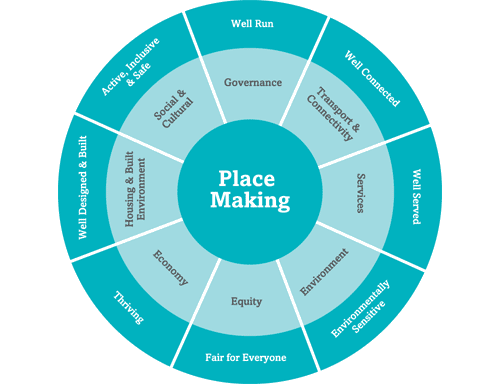
The creation of successful places is a shared activity between local authorities, infrastructure providers, designers, businesses and local communities. Successful places share a number of common factors. Figure 5.11 illustrates the many components and conditions which are required.
Figure 5.1 Components of Successful Places
While the various components are covered under the respective chapters of the plan (see Chapter 4 Sustainable Housing, Chapter 15 Sustainable Communities and Social Infrastructure, Chapter 8 Transport and Chapter 10 Environment Management) this chapter focuses on ensuring quality and sustainability in the physical form of towns and villages ensuring that they are successful and vital places.
5.2 Climate Change in our Towns and Villages
Our towns and villages are the focus of much of our residential properties and they also contain a significant proportion of our commercial and community building stock, amenities and infrastructure. Many of our towns and villages were founded on rivers or by the coast for economic and transport reasons and as a result are more vulnerable to climate change. In order to respond to the impacts that climate change will have on our towns and villages the Planning Authority will, inter alia:
- Implement necessary flood management measures such as those proposed under the Catchment Flood Risk Assessment and Management Study (CFRAMS).
- Ensure that floodplains and other natural features which retain and filter floodwaters such as wetlands are retained.
- Ensure that development and infrastructure is designed and located so as to minimise the threat from flooding and coastal erosion.
- Ensure that buildings are energy efficient and that materials and structures are resilient to climate change.
- Ensure that development is located so that the need to travel is minimised and modal shift is optimised.
5.3 Policy Context
The NPF acknowledges the importance of rural towns and villages in terms of their economic, administrative and social functions and seeks to activate the potential for renewal and to strengthen and diversify rural towns. It places a strong emphasis on strengthening Ireland’s urban structure by targeting both population and employment growth in urban areas, reversing stagnation and decline, promoting urban infill and brownfield development and ensuring that urban areas are attractive, liveable, high quality places. It envisages that they will be home to diverse and integrated communities. It also focuses on addressing the legacy of rapid growth by facilitating catch-up in amenity, services and employment and creating more self-sustaining settlements of all sizes.
Realising our Rural Potential – Action Plan for Rural Development states that there is no “one-size-fits-all” approach to rural development. Different rural areas have different needs and require different solutions, depending on their local assets, their peripherality, population density, etc. The Council must tailor its policies to fit the character of the respective town or village, some of which have commuter pressures, other have experienced decline and some in more remote coastal are experiencing pressure from tourism related development which is not matched by local growth.
The objectives of the RSES seek to strengthen the region’s urban and rural fabric creating vibrant towns and villages and seeking investment for infrastructure and initiatives to support job creation. This will be enabled through the ‘New Homes in Small Towns and Villages’ initiatives, investment in renewal initiatives and co-ordination between local authorities, Irish Water and other stakeholders. The RSES recommends the implementation of sustainable place frameworks, the '10-minute town' concept and the development of 'smart towns'.
Further guidance on how we should lay out our towns and villages to be attractive places which are safe places to live and which are efficient, adaptable and resilient is provided in the following government guidance:
- Design Manual for Urban Roads and Streets (Department of Transport, Tourism and Sport and the Department of Housing, Planning and Local Government, 2019).
- Urban Design Manual – A Best Practice Guide, Companion to the Sustainable Residential Guidelines for Planning Authorities (Department of Environment, Heritage and Local Government, 2009).
- Quality Housing for Sustainable Communities (Department of Environment Heritage and Local Government, 2007).
- Urban Development and Building Height – Guidelines for Planning Authorities (Department of Housing, Planning and Local Government, 2018).
- Sustainable Urban Housing: Design Standards for New Apartments – Guidelines for Planning Authorities (Department of Housing, Planning and Local Government, 2020).
- Retail Design Manual, A companion Guide to the Retail Planning Guidelines for Planning Authorities (Department of Environment, Community and Local Government and Department of Arts, Heritage and the Gaeltacht, 2012)
- Government Policy on Architecture 2009-2015 (2009).
- Architectural Heritage Protection Guidelines for Planning Authorities (Department of Environment, Heritage and Local Government, 2004).
5.4 Goal
It is the goal of the Council to ensure that the towns and villages in the county are vibrant and inclusive, support their urban and rural communities and provide attractive and enjoyable living and working environments.
5.5 Strategy
The Council’s strategy is to create attractive, healthy, safe and efficient places through its own interventions and ensuring that all future developments achieve the highest standards in design and layout. Having regard to this, the key aims of the strategy are:
- Design Quality - To ensure that our towns and villages are attractive places to live and visit and that the design of development and the public realm is of exceptional quality.
-
Place Based Design - To ensure that all new development is designed to respect, enhance and respond to its natural, built, cultural and social context.
- Connected Places - To ensure that future development has a coherent urban structure, is permeable and places people at the heart of the public realm.
- Compact and Rejuvenated - To ensure that development results in the efficient use of land, encourages walking and cycling and rejuvenates the area within which it is located.
- Vibrant, Inclusive, Resilient and Adaptable -To ensure our towns and villages are self-sustaining places which are vital and vibrant, with appropriate services, jobs, amenities and community facilities which are inclusive, accessible to all and are resilient to challenges such as climate change and economic instability.
Towns and Villages Strategic Objectives
It is the objective of the Council:
Objective TV01
Objective TV02
Objective TV03
Objective TV04
Objective TV05
Objective TV06
Objective TV07
Objective TV08
Objective TV09
Objective TV10
Objective TV11
To require that all development complies with the design advice contained in the narrative and the objectives of this chapter and the design principles set out in the guidance documents in Section 5.3 of this chapter.
Objective TV12
5.6 The Design Process
The Urban Design Manual, which accompanies the ‘Guidelines for Sustainable Residential Development in Urban Areas’ (May 2009), provides comprehensive guidance on design issues. The Manual sets out a series of 12 design criteria for development sub-divided into three groups: (i) Neighbourhood (ii) Site and (iii) Home. These groups reflect the spatial scales and order of priorities that should help inform and guide the design of any new residential, mixed-use and commercial development.
Figure 5-2 Criteria for Successful Place-Making
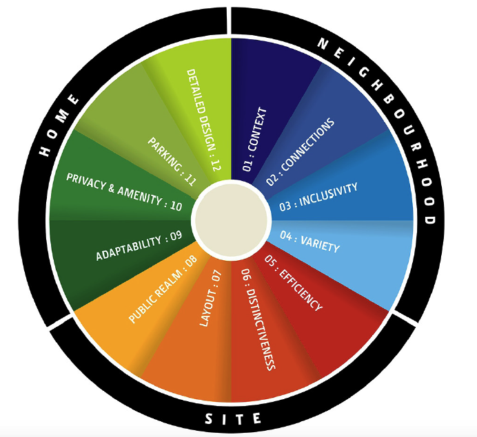
The criteria and associated indicators are included in the Development Management Manual contained in Volume 2. This chapter provides advice on the application of the more important criteria, such as Quality (Section 5.7), Connections (Section 5.9), Efficiency (Section 5.10 Compact Growth), and Inclusivity and Adaptability (Section 5.11). Together with the other guidance documents referred to above, the criteria shall be used by designers to appraise sites and inform the design of new development.
The Council will require the submission of a Design Statement to accompany all development over 2ha, commercial or mixed use schemes in central areas, residential schemes above 50 houses in towns and on a case by case basis in villages where the sensitivity to change is higher due to considerations of scale. Details of what shall be addressed in a Design Statement are included in Section 2.3 of the Development Management Manual.
Specific development management standards with regard to the design of individual sites and dwellings are also contained in the Development Management Manual.
5.7 Design Quality
The quality of design in our towns and villages determines how we use them and how we feel about them. This applies equally to our buildings, streets and public spaces, the places where we work and where we live. Good design is a good investment as people come to and stay in attractive places. As such quality design is an investment in quality of life and in economic prosperity.
New urban form must create interest and a ‘sense of place’ and it must have quality and distinctiveness that will make people attached to it and have pride in it as their place. Places should be legible and people should be able to way-find using the buildings and spaces.
Quality must be considered at every level from neighbourhood to individual building design and the spaces between them. It must be evident in the building form and streetscapes, public realm and spaces, landscaping and the materials and finishing on building and spaces.
5.7.1 Architectural Quality
‘The architecture we choose to build now is the architectural heritage of the future’ (Government Policy on Architecture 2009-2015, 2009:8).
Quality architecture addresses beauty, functionality, durability, adaptability, amenity, liveability and a positive sense of place. Good architecture ensures that the building is fit for its intended use or function, answers the profound challenges of environmental sustainability and climate change2, is durable in terms of its design and construction and respects and enhances its environment aesthetically. Such architecture gives us enduring social, environmental, cultural and economic benefits3.
5.7.2 Designing the Public Realm
The public realm describes a variety of spaces, such as squares, neighbourhood centres, parks, quays and streets. As all developments will have at least an interface with the public realm, and in most cases will be at least partially comprised of public areas, the design and quality of the public realm will be crucial to the quality of the scheme.
In general, the quality of the public realm should be as high, if not higher, than the quality of the individual buildings – a neighbourhood with poor quality spaces will rarely be improved by the highest quality architecture buildings. Buildings should not sit in space, rather they should be used to define and shape the public area. Consideration must be given to how the buildings and spaces interact and are to make attractive and welcoming places.
Designing Quality Places Objectives
It is the objective of the Council:
Objective TV13
Objective TV14
Objective TV15
Objective TV16
Objective TV17
Objective TV18
Objective TV19
Objective TV20
To support proposals from local communities and community organisations to prepare a Village Design Statement for a particular village through a process involving community participation, the Heritage Council and the Council’s Planning Department subject to availability of resources.
5.8 Place Based Design-Context
An understanding of ‘place’ context and appreciation of character is at the core of good design. New development should be designed to respect, enhance and respond to its natural, built, cultural and social context. This should not be seen as a constraint but as a resource to create interesting, attractive and distinctive places.
New development should be designed to respect and complement heritage assets and character. Cues can be taken from the existing built form, scale, massing, plot widths and urban grain. Building lines and building heights should be observed and the response should demonstrate how these factors have been taken into account while at the same time achieving compact and efficient growth. The intention is not to replicate scale and form but to respond appropriately and use opportunities presented by landform or adjacent urban development to create more intensive development patterns while avoiding abrupt changes in scale in historic environments.
Contextual development in our smaller towns and villages warrants special attention given the number of villages scattered throughout Wexford’s countryside, their unique character and appeal and their smaller scale and thus sensitivity to change. The expansion of villages is appropriate and necessary to prevent the decline of rural areas, provide rural employment as an alternative to commuting and to provide an alternative to one off rural housing.
New development must respond to the natural landscape and make optimum use of the opportunities presented by the natural features of the site. Features such as watercourses, hedgerows, wetlands and tree stands must be identified and incorporated in the site. Care must be taken to ensure that features such as rivers and streams are left open, and that buildings and spaces appropriately address them. As well as adding to the character and value of the place these features act as natural measures to absorb surface water, absorb carbon and allow for the enhancement and dispersal of plant and animal diversity in our town and villages. It is important to identify how these natural features will be connected to each other and to those outside the site, as continuity is imperative for both surface water and biodiversity.
Place Based Design Objectives
It is the objective of the Council:
Objective TV21
To ensure that all new development is designed to respect, enhance and respond to its natural, built, cultural and social context and add to character and sense of place.
Objective TV22
To ensure that new development has regard to the scale of the settlement and the ability of the settlement to absorb further development. In deciding whether any given development exceeds the absorption capacity of the settlement, as well as the absolute quantum of development, the Planning Authority will also have regard to scale, bulk and massing of the individual buildings and groups of buildings.
Objective TV23
To ensure that new development responds to the natural features of the site and wider settlement. To ensure that features are identified in planning applications and preserved. The Design Statement required for the site (or site layout where a Design Statement is not required) should identify the features to be retained and design measures to enhance the biodiversity of the settlement such as linking green or blue features within and outside the site.
Objective TV24
To encourage and participate in heritage led regeneration, including consideration of the potential to participate in the Heritage Council’s Historic Towns Initiative, and to adopt a Town first approach to the revitalisation of historic urban centres which focuses on the repair and upgrade of existing historic buildings and their adaptation to new uses with regard to their architectural character and significance.
5.9 Connected Places and Design of Streets
5.9.1 Street Networks, user priority and permeability
The majority of the public space or public realm in our towns and villages is comprised of streets. Streets are also the basic building block of urban structure and therefore the design of street networks and streets is of crucial importance to creating sustainable, walkable and attractive towns. However, one of the legacies of residential layout design in the recent past has been that design considerations have often been dominated and driven by the need to make provision for motor vehicles – to the detriment of other users. The standards and guidelines set out in the Design Manual for Urban Roads and Streets (hereon referred to as DMURS) must be applied by the Council in relation to all urban roads and streets, that is, streets and roads with a speed limit of 60 km/h or less5 .
The Manual recognises the importance of assigning higher priority to pedestrians and cyclists , without unduly compromising vehicle movement in order to create secure, connected places that work for all members of the community.
New development should provide for optimum levels of connectivity and permeability through careful consideration of layout and design. Permeability refers to the ease of movement within any given area particularly for pedestrians and cyclists. Permeable urban environments encourage increased participation in sustainable modes of travel including walking, cycling and public transport. Further Guidance on permeability is provided in Permeability Best Practice Guide (National Transport Authority, 2015).
While in general, the principle is that every street must lead to a street, network design does not have to result in complete permeability for all modes of transport.
5.9.2 Route Hierarchy
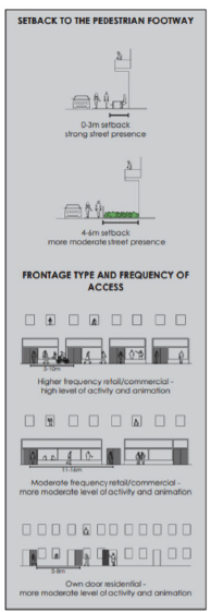
In general the urban street network is comprised of a hierarchy of routes of differing design and function. DMURS recognises the different ‘movement functions’ or roles which particular routes play and sets out a hierarchy of route types and characteristics. It identifies a route hierarchy with three route types; Arterial, Link and Local Routes. As well as detailed road design and movement function, the type of route will inform the design, building line/frontage, building type, building height, density and landscape treatment.
Arterial Routes are the major strategic routes that connect major centres and nodes. They may also include orbital routes. Pedestrians, cyclists and public transport should be prioritised on these routes but they may also need to convey a volume of individual traffic movements. The routes have a higher design speed and greater width. They can accommodate buildings of greater height which will serve to provide continuity and enclosure of these wider routes. Legibility and landmarks will be important considerations on these routes to enable way finding and convey a sense of place in these more fast moving routes.
Link Routes provide the links to Arterial routes or between centres, neighbourhoods and/or suburbs. Their movement function will still be significant but they will have a lesser volume of traffic with a destination outside the town. They cater for shorter journeys and the design, width and design speed is lower. These routes can still accommodate building height which shall be proportionate to the road width to ensure appropriate enclosure (see below). There should be particular attention to the different characteristics of the areas through which they pass. A higher standard of design will be expected in places with more important ‘place’ function (see below).
Local Routes are the routes which provide access within communities and to link Arterial and Link routes. Their movement function is much less important and the ‘place’ function is paramount. They may even be fully pedestrian or they may serve a number of modes of transport. They are a more intimate space where people will dwell and the movement function is secondary to their function as a place.
DMURS notes that the character of these routes will change across their length as they pass through various ‘places’; rural areas, villages, suburbs, neighbourhood centres/nodes and town centres. The design treatment will therefore also vary depending on the ‘place context’. For example in locations such as neighbourhood centres and intersections a higher design quality will be expected and higher levels of pedestrian connectivity and vibrant and responsive frontages will be required.
These roles will be assigned and new routes planned in the respective Local Area Plans. However, in many of the County’s towns and villages there are no local area plans and in such instances6 designers should seek the advice of the Planning Authority at the preplanning stage to ascertain the envisaged role for the route where this is not set out in a local area plan.
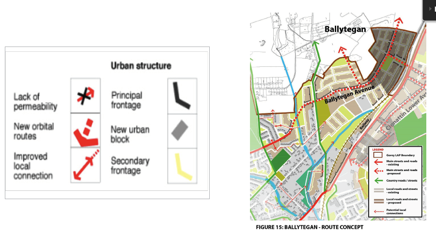
Figure 5-3 below shows the proposed route structure of a new area and shows how the route type influences the type of building frontages required (Principal and Secondary).
Figure 5-3 Example of a Proposed Route Structure
The Development Management Manual contained in Volume 2 provides further indicative cross sections for Arterial, Link and Local Routes7. The sections show carriageways, cycle tracks, building lines and heights, landscaping privacy strips and SUDS for each route type– all of which contribute to creating a comfortable, attractive and safe space which is designed to reflect the function of the route.
In designing new routes, it is important in the interests of street design, street enclosure and land efficiency that buildings front onto the street. Separate access roads which run parallel to the existing route will not be permitted.
5.9.3 Street Design
New street and road design must put primary emphasis on creating attractive places which are accessible by all and which, secondly, serve their movement function. A broad range of place-based measures such as built form, landscaping and levels of pedestrian and cyclist activity, as well as more conventional road design measures, will need to be taken into account in making streets function as places.
A key challenge is to successfully promote the non-car based functions of ‘the street’ by promoting a ‘sense of place’, facilitating social interaction and encouraging walking and cycling. It is important that the space between buildings is carefully considered in relation to the scale of the buildings and the activities taking place on the new streets.
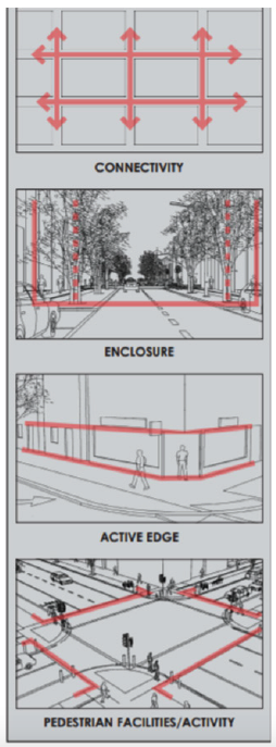
DMURS focuses on streets as attractive places and seeks to ensure that design is appropriate to context, character and location. The manual identifies four key characteristics of place based street design:
- Connectivity
- Enclosure
- Active Edge
- Pedestrian Facilities / Activity
Connectivity of the route network is dealt with extensively in Sections 5.9.1 and 5.9.2 of this chapter. At the street level the creation of vibrant and active places requires pedestrian activity and this in turn requires walkable, permeable street networks. Well-designed connections should be overlooked by active accommodation to give passive supervision. Passive vehicular traffic can also provide a level of surveillance. There should be good visibility from other areas to minimise opportunities for hiding/crime. It is beneficial to retrospectively improve connectivity with well-designed connections where possible to increase pedestrian activity and walkability. Further guidance is available in Permeability - A Best Practice Guide (NTA).
Enclosure is an important element of street design. New streets and spaces should be continuously and adequately enclosed by building frontages and landscape. Existing continuity should be maintained where it exists (building lines and forms) and opportunities to address weaknesses should be realised through infill development or redevelopment. Further detail and dimensions are provided on the role of building height and street width in creating enclosure in Section 4.2.1 of DMURS.
of place based street design
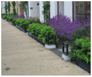
An active edge livens the street creating a more interesting and engaging environment. An active frontage is achieved with frequent edges and openings to ensure that the street is overlooked to generate pedestrian activity as people come and go from buildings. Where residential development fronts onto streets, a higher level of privacy is desirable. This can be provided at ground floor level with a ‘privacy strip’ (see Figure 5.5 and Section 4.2.3 DMURS) or change in level to create separation and privacy without compromising the active edge. Providing a planted privacy strip helps to define public and private space, protect residential amenity and provides an attractive street edge.
The inclusion of in-curtilage parking in front gardens results in large setbacks and reduces the sense of enclosure and will only be considered in exceptional circumstances (or in outer suburban areas and villages). Car parking should not dominate the streetscape. On-street or underground parking increases site potential and allows for a stronger street frontage. Where possible apartment developments should be designed to include own door entrances for ground floor units. This will create a greater level of street activity.
Good pedestrian activity/facilities such as wide footpaths and well-designed crossings can make walking a more convenient and pleasurable experience that will further encourage pedestrian activity and vibrancy. DMURS provides more detail on the various zones within the pedestrian area - made up of the strip, footway and verge. These areas should be viewed and designed as three areas of activity.
Figure 5.6 The three activity zones of the footpath
(Source: DMURS)
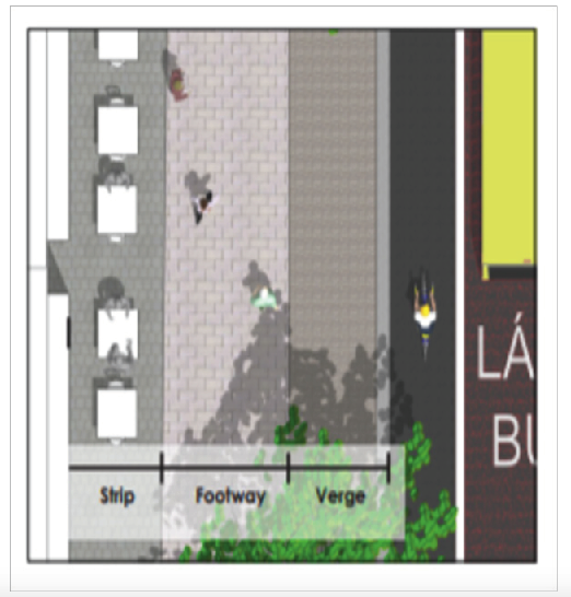
Figure 5.7 Measures that indicate active and animated street interfaces
(Source: DMURS)
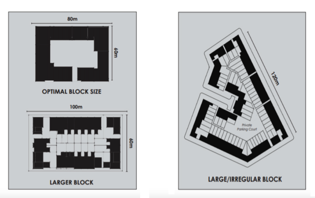
Urban Blocks
Urban blocks are an important component of street design. They are the basic development parcels that remain once open space, streets, footpaths and other public spaces have been removed. Our historic towns are made up of contrasting buildings that work together because they sit together in coherent blocks. Proper block layout is also crucial to achieving compact urban form and the development of successful places.
Urban blocks need to be sized and shaped to accommodate development of different uses and types. DMURS sets out detailed guidance for the design of urban blocks. With regard to block dimensions the following apply:
- 60 – 80m is optimal for pedestrian movement and will sustain a variety of building types. This should be used within intensively developed areas such as centres to maximise accessibility;
- Larger blocks within centres and business parks / industrial estates may be required to cater for larger commercial or civic developments. In such cases mid-block pedestrian links should be provided;
- A block dimension of up to 100m will enable a reasonable level of permeability for pedestrians and may also be used in neighbourhoods and suburbs;
- In some cases, site constraints may require designers to apply larger block dimensions. However, maximum block dimensions should generally not exceed 120m.
Urban blocks for residential areas tend to be smaller than blocks for industrial areas where buildings and spaces are larger. The perimeter block provides the greatest flexibility of urban block types. It provides coherent frontage to streets and spaces and it provides a clear distinction between public and private spaces. The block and adjoining blocks should align to create well defined streets and spaces with relatively continuous active frontage, made up of doors and windows to create attractive and well supervised streets and public spaces.
Figure 5.8 and 5.9 Block Types
(Source: DMURS)
5.9.4 Streets - Detailed Design and Safety
DMURS provides further detail of the role of street trees, lighting, street furniture, materials, signage, historic streets, pedestrian and shared areas, cycling facilities including cycleway design and carriageway alignments. It also contains detailed advice on the design of radii, carriageway width, surfaces, visibility and splays, alignment curvature and deflections and parking.
Careful consideration should be given to junction design; all junctions must meet DMURS standards and there will be a presumption against roundabouts in favour of standard junctions (either signalised, priority or uncontrolled). Existing large scale roundabouts may where necessary be retrofitted or replaced by standard junctions along main routes to achieve better provision for cyclists and pedestrians and to provide for the redevelopment of key corner locations.
DMURS promotes a design approach which seeks to create self-enforcing low speed environments in urban areas. In terms of road safety, the speed at which a driver travels is principally influenced by the characteristics of the street environment (Section 4.1.2). Integrated design approaches incorporate elements that instinctively alter behaviour thus reducing the need for more conventional measures. The Manual sets out8 a matrix of appropriate design speeds which reflect the route type and context and user priority.
Where national roads pass through settlements, and where the speed limit on that road is between 50km/h and 60 km/h, regard shall also be paid to the Transport Infrastructure Document ‘The Treatment of Transition Zones to Towns and Villages on National Roads’, which describes the requirements that shall be implemented on national roads in terms of the provision of traffic calming measures and pedestrian crossings.
Connected Places and Street Design Objectives9
It is the objective of the Council:
Objective TV25
Objective TV26
Objective TV27
Objective TV28
Objective TV29
Objective TV30
Objective TV31
Objective TV32
5.10 Compact Growth and Regeneration
The NPF acknowledges that the physical format of urban development is one of our greatest national development challenges and identifies ‘Compact Growth’ as the first NSO. Increasing the number of people living within the footprint of our existing towns and villages will result in more sustainable and resilient growth as it maximises opportunities for people to walk, cycle and the potential for the development of public transport. It also optimises the use of physical and community infrastructure and supports the economic viability of local retail facilities and other services. High quality design, coupled with high quality amenity is, however, fundamental to establishing successful compact urban areas.
RPO 27 of the RSES recognises the need to be more flexible in terms of such growth in rural villages. A one size fits all will not be appropriate or sustainable.
Section 10(2)(h) of the Planning and Development Act, 2000 (as amended) has been extended and now requires a development plan to include objectives for the redevelopment and renewal of areas identified having regard to the Core Strategy, that are in need of regeneration, in order to prevent –
- adverse effects on existing amenities in such areas, in particular as a result of the ruinous or neglected condition of any land,
- urban blight and decay,
- anti-social behaviour, or
- a shortage of habitable houses or of land suitable for residential use or a mixture of residential and other uses.
This renewed emphasis on improving and regenerating areas requires local authorities to take a proactive approach to ensure their renewal.
There are significant opportunities for targeted regeneration and renewal while at the same time increasing the number of people living and working within the existing built up area of our towns and villages. These opportunities include:
- The creation of street networks, streets, buildings, blocks and places (See Section 5.9 of this chapter) which not only is an appropriate form of development in terms of permeability but is also an effective means of achieving compact growth.
- Infill, backland and brownfield development.
- Active land management including site assembly and the use of CPOs.
- Appropriate zoning of new land and matters such as density and building heights.
- Applying a more flexible approach to development management standards such as separation distances, open space provision and parking subject to performance criteria and design quality being achieved.
- Reusing or redeveloping existing sites including building more intensively
- Developing institutional lands.
5.10.1 Infill, Brownfield and Greenfield Development
There are many opportunities to increase the number of jobs and people within central areas through infill development which achieves the dual objectives of compact growth and regeneration. The development of these sites will prevent car-dependent sprawl and resulting unsustainable patterns of commuting and service provision. It will also rejuvenate these areas, many of which have been declining in population, by bringing new people to the area and create demand and customers for existing services. There will therefore be a presumption in favour of development which can encourage more people, jobs and activities within our towns and villages. The Council has outlined in Objective CS04 its commitment to prepare an audit of available brownfield sites over the plan period.
In accordance with the requirement of the NPF the Council will ensure that 30% of all new homes that are targeted in settlements will occur within their existing footprint11. The NPF states that this will apply to all settlements as defined by CSO12. This will be implemented through the various local area plans and settlement plans. There are a range of opportunities for the delivery of housing units on infill and brownfield sites within our town and villages.
Types of Brownfield and Infill Lands
Infill Sites
Potential sites may include gap infill sites, unused or derelict land, institutional lands and backland areas, up to larger residual sites assembled from a multiplicity of ownerships. Smaller scale infill may be achieved through:
· Conversion of non-residential properties to residential use;
· Subdivision of larger residential plots to provide residential units; or
· Subdivision of larger residential properties to provide individual units within them
Brownfield Sites
Brownfield land is defined as ‘any land which has been subjected to building, engineering or other operations, excluding temporary uses or urban green spaces’13. It may comprise redundant industrial or commercial lands, docks, barracks, hospitals or obsolete housing areas. The Council will identify appropriate brownfield land upon which housing could be delivered when preparing local area plans and settlement plans.
Remediation of Brownfield Sites:
The Council will ensure that appropriate environmental appraisals are carried out early in the project development for brownfield sites and will require the preparation of Construction and Development Waste Plans carried out in accordance with the ‘Best Practice Guidelines for the Preparation of Waste Management Plans for Construction and Demolition Projects’ published by the Department of Environment, Community and Local Government. Further details are included in Section 9.7.5 in Chapter 9 Infrastructure and Volume 2 Development Management Manual.
Greenfield Expansion
In settlements which do not have local areas plans or settlement plans or defined boundaries under this Plan, the Council will only consider the sequential development of the village. In villages such as Rosslare Strand and Castlebridge, which have significant potential for inner and outer infill, development will only be permitted within the existing built-up area. Greenfield expansion outside the existing built up area will not be permitted. The Council will also protect the edge of all settlements from ribbon development in order to allow for their orderly development in the future.
Scale of Infill
The scale of infill development will depend on the location of the site and the characteristics of the settlement. In areas where a LAP applies this will be specified in the LAP. Where no LAP is in place the Council will consider the scale of infill development having regard to the need to make efficient use of centrally located sites and the prevailing scale in the area. The Council will encourage development which intensifies the use of the land to, at minimum, the intensity of adjoining uses but optimally, subject to the appropriate protection of amenities of adjoining residences to a higher intensity. The Council will consider the relaxation of quantitative standards subject to certain performance standards being met.
Re-use of Vacant Buildings and Upper Stories
The Council will encourage the reuse of vacant buildings and the use of the upper stories in towns and villages for either the same use or alternative uses including more intensive uses subject to the development meeting performance standards and protecting amenities of adjoining occupants.
With regard to both the reuse of vacant buildings and the use of upper floors in central areas, the Council will be flexible in the application of development management standards and will consider the introduction of schemes to incentivise such reuse.
5.10.2 Regeneration - Active Land Management and Local Authority Intervention
There are significant portions of well-located lands adjacent to town and village centres and public transport facilities, some of which are in public ownership. The Council will work together with the Land Development Agency to facilitate the appropriate redevelopment of these sites.
Other sites have complex ownership patterns and/or may present issues with multiple consent procedures (such as Foreshore Licences). Activating these areas may require a level of active land management which is prohibitively complex for private developers and which, before now, Councils have previously not been involved in.
The Council is committed to targeted intervention in the interest of rejuvenation and efficiency of land use/sustainability and has taken the first steps in this regard having purchased a centrally located brownfield site in Wexford Town. The Council has been successful in obtaining planning permission and Urban Regeneration Development Fund (URDF) backing for Trinity Wharf, a high quality, compact urban development in an area of the town in need of regeneration. It is one of a number of schemes being pursued by the Council which will achieve the dual aims of compact growth and regeneration.
The Council will consider interventions such as site assembly using CPO, demolition and clearance or decontamination and the provision of facilitating infrastructure. When sites are acquired the Council will decide on the most appropriate mechanism to ensure appropriate rejuvenation which may include redevelopment for civic or amenity uses, public and private housing or the release of the land back to the market for redevelopment.
The Council will encourage and actively participate in such activities and will also leverage the variety of funds including LIHAF, Urban and Rural Regeneration and Development Funds, Climate Activation Fund and Disruptive Technologies Fund to achieve compact growth and regeneration of our towns and villages. In this regard priority will be given to projects which result in social and economic rejuvenation and regeneration and the provision of amenities and services where these are deficient.
Table 5-1 shows the Council’s priority locations for active land management and regeneration. In some cases, these will be major development proposals and in smaller settlements this may be limited to support for public realm proposals and implementation of the Derelict Sites and Urban Regeneration and Housing Acts. In all cases this will be subject to appropriate resources and funding and it is not intended that all actions will take place in all locations. Table 5-2 contains priority projects and target delivery timelines.
Table 5-1 Priority Locations for Active Land Management and Regeneration14
|
Settlement |
Proposed Interventions |
|
Wexford Town
|
Master-planning/design briefs, developments consents, site assembly including CPO, site remediation, enabling infrastructure, site development works, property development, public realm development, Derelict Sites, Vacant Sites/Urban Regeneration legislation.
|
|
Gorey Town
|
Master-planning/design briefs, developments consents, site assembly including CPO, sites remediation, enabling infrastructure, site development works, property development, public realm development, Derelict Sites, Vacant Sites/Urban Regeneration legislation. |
|
Enniscorthy Town
|
Master-planning/design briefs, developments consents, site assembly including CPO, site remediation, enabling infrastructure, site development works, property development, public realm development, Derelict Sites, Vacant Sites/Urban Regeneration legislation.
|
|
New Ross Town
|
Master-planning/design briefs, developments consents, site assembly including CPO, site remediation, enabling infrastructure, site development works, property development, public realm development, Derelict Sites, Vacant Sites/Urban Regeneration legislation.
|
|
Courtown and Riverchapel
|
Public realm, Vacant Sites/Urban Regeneration legislation.
|
|
Rosslare Harbour
|
Public realm, Vacant Sites/Urban Regeneration legislation.
|
|
Bunclody Town
|
Public realm, Vacant Sites/Urban Regeneration legislation.
|
|
Castlebridge
|
Public realm, Vacant Sites/Urban Regeneration legislation.
|
|
Rosslare Strand
|
Public realm, Derelict Sites, Vacant Sites/Urban Regeneration legislation.
|
| Ferns | Public realm, Derelict Sites |
| Kilmore Quay | Public realm, Derelict sites, CPO and land assembly. |
| Bridgetown | Public realm, Derelict Sites. |
| Taghmon | Public realm, Derelict Sites. |
Table 5.2 Timeline for Key Active Land Management Proposals
| Project | Proposal | Timeline |
|---|---|---|
| Wexford Town | ||
|
Monck Street Public Realm |
Public realm intervention |
Construction commence – Sept 2021 |
| Trinity Wharf Urban Quarter, Marina and Boardwalk | Redevelopment of central, brownfield site, land assembly, development consent, remediation, infrastructure and realm development. |
Planning permission granted by ABP – April 2020 Access road – construction commence - Q2 2021 Site development works – commence – Q4 2022 |
| Crescent Quay Regeneration - Old Tesco Site | Redevelopment of central vacant properties, land assembly, design brief, infrastructure provision. |
Planning permission granted by ABP – April 2020 Construction commence – September 2021 |
|
Gorey Town |
||
| Market House | Land assembly/CPO, infrastructure provision. |
Local Authority consent - May 2018 |
| Esmonde Street | Public realm intervention. |
Local Authority consent -December 2020 Construction commence – Q4 2021 |
| Ballytegan | Masterplan for sustainable neighbourhood, land acquisition, infrastructure provision, realm development. | Masterplan preparation to commence 2021 |
| Enniscorthy Town | ||
| Enniscorthy Tourism Project |
Major public realm and tourism regeneration development surrounding/including Enniscorthy Castle in centre of town. |
Application for planning permission – Q2 2022 |
| Enniscorthy Heritage Led Regeneration – under Heritage Towns Initiative | Public realm intervention/regeneration Slaney Street and Mary Street in centre of town. | Completion 2022 |
| Enniscorthy Town Centre – Urban Renewal, Regeneration and Economic Plan |
Development and implementation of an urban regeneration and renewal plan for the town centre.
Later phases to include: Developments consents, site assembly including CPO, site remediation, enabling infrastructure, site development works, property development, public realm development, Derelict Sites, Vacant Sites/Urban Regeneration. |
Completion of Plan 2022 |
|
New Ross Town |
||
| New Ross Destination Town |
Way finding, public realm improvement, place making and identification, Derelict/Vacant sites/Urban regeneration |
|
|
High Hill Public Realm |
Site assembly, public realm development. |
Commence Construction – Q2 2021 |
|
Removal Oil Tanks on Quays |
Site assembly, public realm development, |
Start Construction – Q2 2021 |
| John Street Hatch Lab | Site assembly, public realm development. |
Application for planning – Q3 2021 |
5.10.3 Vacant Sites, Derelict Sites and Dangerous Sites
Vacant Sites
The Urban Regeneration and Housing Act 2015 (as amended) introduced the Vacant Site Levy, the intention of which is to incentivise the development of vacant sites in urban areas for residential and regeneration purposes.
The levy will support the implementation of the Core Strategy and Settlement Strategy objectives, particularly in respect of promoting the renewal and regeneration of urban areas, ensuring a compact urban form and sustainable growth patterns, and in achieving the population targets and meeting the housing needs of the county.
For the purposes of the 2015 Act, a site is a vacant site15 if
- In the case of residential land the site is in an area in which there is a need for housing, is suitable for the provision of housing and is, or the majority of the site is, vacant or idle.
- In the case of regeneration land, the site or the majority of the site is vacant or idle and the site being vacant or idle has adverse effects on existing amenities or reduces the amenity provided by existing public infrastructure and facilities in the area in which the site is situated or has adverse effects on the character of the area.
The implementation of the Vacant Site Levy requires the Council to identify sites in the county which are vacant and come within the scope of the Urban Regeneration and Housing Act 2015 (as amended). Any sites identified are to be entered on a Vacant Sites Register that is to be monitored by the Council. The amount of the Vacant Site Levy is set out in Section 16 of the Urban Regeneration and Housing Act 2015 (as amended) and shall be equal to 7% of the market value of the site for 2019 and subsequent years (unless otherwise revised).
As part of the HNDA and the preparation of the Housing Strategy, areas with a ‘housing need’ as defined in the Act were identified. When new local area plans are prepared, lands will be designated for the purposes of applying the levy in the case of both residential and regeneration lands. This presents a snapshot of a particular time and will be a living document and will be updated regularly.
Table 5-3 sets out the relevant zonings which are designated as Residential and Regeneration zonings in the development plans, local area plans and settlements plans to which the levy may be applied and lands which are designated for regeneration (until these are replaced by new LAPs where appropriate).
Table 5-3 Land Use Zoning for the purpose of Vacant Sites Levy
|
Plan |
Residential Zonings |
Regeneration |
|
Wexford Town and Environs Development Plan 2009-2015 (as extended) |
Residential & Infill, Mixed Uses & Residential, Town Centre, Neighbourhood Centre and Commercial & Mixed Uses |
All zoned lands within the plan area. |
|
Gorey Town and Environs Local Area Plan 2017-2023 |
Residential, Long Term Residential and Central Business Area |
The area designated as Regeneration lands on Map 11 in the plan. |
|
Enniscorthy Town and Environs Local Area Plan 2008-2014 (as extended) |
Existing Residential & Infill, New Residential, Mixed use & Residential, Commercial & Mixed Use, Town Centre and Village Centre. |
All zoned lands within the plan area. |
|
New Ross Town and Environs Development Plan 2011-2017 (as extended) |
Existing Residential, New Residential, Town Centre, Neighbourhood Centre and Mixed Use. |
All zoned lands within the plan area. |
|
Courtown and Riverchapel Local Area Plan 2015-2021 (as extended) |
Existing Residential, New Residential and Village Centres. |
All zoned lands within the plan area. |
|
Bunclody Settlement Plan |
Town Centre, Existing Residential and New Residential. |
Specific identified lands in the Town Centre and Commercial and Industrial lands. |
|
Rosslare Harbour and Kilrane Settlement Plan |
Village Centre, Existing Residential and New Residential. |
Lands identified for Regeneration in the Village Centre |
|
Taghmon Local Area Plan 2009-2015 (as extended) |
Low to Medium Residential, Mixed Use & Residential and Village Centre |
All zoned lands within the plan area. |
|
Clonroche Local Area Plan 2009-2015 (as extended) |
Residential, Mixed Use & Residential and Village Centre |
All zoned lands within the plan area. |
5.10.4 Derelict Sites
Derelict sites are controlled under the Derelict Sites Act 1990. A “derelict site” means any land which detracts, or is likely to detract, to a material degree from the amenity, character or appearance of land in the neighbourhood of the land in question because of;
- the existence on the land in question of structures which are in a ruinous, derelict or dangerous condition, or
- the neglected, unsightly or objectionable condition of the land or any structures on the land in question, or
- the presence, deposit or collection on the land in question of any litter, rubbish, debris or waste, except where the presence, deposit or collection of such litter, rubbish, debris or waste results from the exercise of a right conferred by statute or by common law.
The Council will continue to use its powers under the Derelict Sites Act to ensure that sites in urban and rural locations which are deemed derelict are investigated and remedied subject to available resources. It may be necessary to prioritise certain types of sites having regard to available resources. In this regard the Council will prioritise sites on main routes and thoroughfares, adjacent to heritage buildings or protected natural heritage sites or on tourism and amenity routes and trails, adjacent to schools and other sensitive receptors, where they interfere with economic development or employment uses and other sites where public health or safety concerns arise.
5.10.5 Dangerous Sites
The Council will continue to regulate Dangerous Sites under the Local Government (Sanitary Services Act) 1965.
5.10.6 Building Heights and Density
Scale and height are important elements of urban form. Scale is the size of a building in relation to its surroundings and incorporates height and massing. Height is the number of storeys of a building. In evaluating the scale and height of proposed development, it is necessary to balance the strategic planning need to make the most efficient use of each site while ensuring the highest standard of urban design, architectural quality and place-making outcomes on the other.
Local context is a key element in determining appropriate scale and height and a well-considered design is required to minimise effects on existing environmental, heritage, residential and visual amenities and assets.
The Urban Development and Building Heights - Guidelines for Planning Authorities (Department of Housing, Planning and Local Government, 2018) acknowledge that increasing prevailing building heights have a critical role to play in addressing the delivery of more compact growth in our urban areas, particularly large towns. The Guidelines require that the scope to consider general building heights of at least three to four stories, coupled with appropriate density, in locations outside what would normally be defined as the city or town centre and which would include suburban areas, must be supported in principle at development plan and development management levels. The Guidelines also contain an SPPR which requires local authorities to identify in the development plans locations where increased building heights will apply (SPPR 1).
The Guidelines further state that in cities and towns identified for significant growth in the RSES ‘it would be appropriate to support building heights of at least six storeys as the default while allowing the scope to increase above this level’. Wexford Town and Gorey have been identified in the RSES as Key Towns capable of significant growth.
The Guidelines state that they apply to all urban areas as defined by the CSO16. The Council considers, however, that a ‘one size fits all’ approach to building heights is not appropriate, particularly outside our four main towns.
Compact Growth Objectives
It is the objective of the Council:
Objective TV33
Objective TV34
Objective TV35
- adverse effects on existing amenities in such areas, in particular as a result of the ruinous or neglected condition of any land,
- urban blight and decay,
- anti-social behaviour, or
- a shortage of habitable houses or of land suitable for residential use or a mixture of residential and other uses.
Objective TV36
- The creation of street networks, streets, buildings and blocks and places which is both an appropriate form of development in terms of permeability and also an effective means of achieving compact growth.
- Utilising opportunities to develop infill, backland and brownfield development.
- Active land management including site assembly and the use of CPOs.
- Appropriate zoning of new land and matters such as density and building heights in local area plans.
- Applying a more flexible approach to development management standards such as separation distances, open space provision and parking subject to performance criteria and design quality being achieved.
- Reusing or redeveloping existing sites including building more intensively.
- Developing institutional lands.
Objective TV37
To establish a Wexford County Council inter-departmental rural regeneration team to co-ordinate active land management and assist with the implementation of projects and proposals that encourage, stimulate and support the regeneration and renewal of the county’s rural towns and villages.
Objective TV38
Objective TV39
Objective TV40
In pursuit of RPO 34 the Council will implement an Active Land Management Strategy including the measures outlined in Tables 5.1 and 5.2 and subject to available resources and appropriate funding sources.
Objective TV41
Objective TV42
Objective TV43
Objective TV44
Objective TV45
Objective TV46
Objective TV47
Objective TV48
- main routes and thoroughfares,
- adjacent to heritage buildings or protected natural heritage sites,
- on tourism and amenity routes and trails,
- adjacent to schools and other sensitive receptors,
- where they interfere with economic development or employment uses, and
- other sites where public health or safety concerns arise.
Objective TV49
In pursuit of Objectives TV47 and TV48 it is the objective of the Council, subject to available resources, to pursue a minimum of:
- Five sites per Municipal District per annum under Derelict Sites legislation; and
- Three sites per annum under the Urban Regeneration and Housing Acts.
Objective TV50
Objective TV51
- Neighbourhood Centres.
- Arterial Routes and in particular routes with public transport and places with high ‘place’ value along these such as urban villages and major junctions.
- Routes served by local intra-town public transport.
- Bounding medium and large amenity areas where tall buildings will increase the sense of enclosure and provide surveillance.
- Other appropriate ‘edge’ sites such as quaysides.
- Local Community Spaces (Gorey LAP and other LAPs as appropriate)
- Corner sites and landmark sites which assist in way finding.
Objective TV52
Objective TV53
Objective TV54
- The immediate and surrounding environment e.g. streetscape, historic character;
- Adjoining structures;
- Open spaces and public realm; and
- Views and vistas.
5.11 Vibrant, Inclusive, Resilient and Adaptable
The sustainable development of our towns and villages must ensure that as well as being attractive and functional that they are vibrant and inclusive, resilient and adaptable (economically, socially and environmentally). These qualities are dealt with in the various Chapters of the Plan:
- Vibrant – Chapter 3 Core Strategy, Chapter 6 Economic Development Strategy, Chapter 7 Tourism Development, Chapter 14 Recreation and Open Space and Volume 8 Retail Strategy
- Inclusive – Chapter 4 Sustainable Housing and Chapter 15 Sustainable Communities and Social Infrastructure Strategy
- Resilient and Adaptable – Chapter 2 Climate Action, Chapter 3 Core Strategy, Chapter 6 Economic Development Strategy, Chapter 8 Transportation Strategy, Chapter 9 Infrastructure Strategy, Chapter 10 Environment Management, Chapter 15 Sustainable Communities and Social Infrastructure Strategy.
Vibrant, Inclusive, Resilient and Adaptable Objectives
It is the objective of the Council:
Objective TV55
Objective TV56
Objective TV57
Objective TV58
- 1 - Figure 1: Place-Making (adapted from Egan’s Wheel Sustainable Communities )
- 2 - Government Policy on Architecture 2009-2015 (2009)
- 3- Places for People, National Policy on Architecture – Discussion Document (Government of Ireland, 2019)
- 4- See Section 5.9.3 Street Design.
- 5- Except: (a) Motorways. (b) In exceptional circumstances, certain urban roads and streets with the written consent of sanctioning authority being either the Transport Infrastructure Ireland or Department of Transport, Tourism and Sport respectively.
- 6- And in instances where the Route Type has not yet been assigned in the Town or Village Plan.
- 7- It also includes a Wexford County Council derivative known as a ‘Country Road’ which seeks to retain the landscape character and biodiversity of approach roads to towns and villages.
- 8- DMURS Table 4.1, Page 64
- 9- See also Section 8.4.5 in Chapter 8 Transportation Strategy which deals with Streets and Roads.
- 10- DMURS, Table 4.1, Page 64
- 11- Built-up footprint of the settlement is defined as the CSO urban settlement boundary in accordance with NPO3c footnote 19.
- 12- A minimum of 50 occupied dwellings, with a maximum distance between any dwelling and the building closest to it of 100m and where there is evidence of an urban centres (shop, school etc).
- 13 Sustainable Residential Development in Urban Areas -Guidelines for Planning Authorities (2009).
- 14 Note: This list is not exhaustive, and the Council may carry out further active land interventions in these and other settlements.
- 15 Site means an area of land exceeding 0.05ha identified by the planning authority in its functional area but does not include any structure that is a person’s home.
- 16 CSO defines urban areas as settlements of 1,500 persons or more.