Section 3: Castlebridge Specific Objectives
3.1 Historical Development
Castlebridge which derives its name from the ancient castle that formerly stood there is situated on the north side of Wexford Harbour, at the confluence of the Castlebridge River with the River Sow and on the road from Wexford to Gorey. The site of the present day First Fruits Church and graveyard is believed to be the site of the ancient castle. The topography of the settlement is marked by higher ground to the north and northwest of the settlement centre with much lower lying ground in other areas.
Castlebridge evolved and developed around two natural resources, barley and water.9 The barley was for malting, brewing and animal feed, and the water to power mills to provide a freight way by canal to and from the quays at Wexford. The first malthouse was built by the Dixons in 1742 who became the biggest malt producer in the country by 1798. The local significance was that a community had formed around the industrial core.
In the late eighteenth century and through the nineteenth century the village reached a peak of six malthouses and two breweries, six pubs, a hotel and four coal-yards. A population of 400 was recorded for the village in the mid-nineteenth century which was described "as one of the biggest and most important in the whole county, a thriving commercial village."10
In 1814 the mill owners built Castlebridge House. Castlebridge House was extended in 1858 and included the iron conservatory, known as the Pierce Atrium, which was designed, built and erected by James Pierce. The mill business was subsequently taken over by the Breen family and they established trading with Guinness from 1836 which lasted to 1973 when the Nunn family sold the business to Guinness.
In 1951 the then Managing Director of Guinness Sir Hugh Beaver was staying with the Nunn family at Castlebridge House. After a day of shooting at the North Slob, a debate started as to the answer to the question ‘What was Europe’s fastest game bird? An exhaustive search of the Castlebridge House library failed to come up with the answer. The inability to find the answer, prompted Sir Beaver to devise a single book of reference which would seek to answer this sort of question. Sir Hugh Beaver appointed twins Norris and Ross McWhirter who ran a fact-finding agency in London to compile the first edition of ‘The Guinness Book of Records’ which was published in August 1955 and became that years number one bestseller. The Guinness Book of Records has remained the bestselling copyrighted series of all time. In 1974 Wexford County Council purchased Castlebridge House. In 1980 Guinness gifted the Community Centre and Reading Rooms to the community.
3.2 Existing Urban Structure and Character
The settlement of Castlebridge is characterised by an organic settlement pattern rather than a planned form. The older part of the settlement is located around the mill and to the south of the Castlebridge River. The community gardens to the front of Castlebridge House add to the attractiveness of the settlement. Both The Reading Rooms and Castlebridge House are important local landmarks for the community.
Significant residential development occurred to the north and south of the village core during the 1990s and 2000s. These were typically cul-de-sac type developments characterised by semi-detached and detached dwellings. Recently there have been two infill developments located close to the village core.
3.3 Profile
3.3.1 Settlement Hierarchy
Castlebridge is designated as a Level 3(a) Service Settlement in the Core Strategy Settlement Hierarchy. Level 3(a) settlements are important service settlements for their local communities and their wider rural hinterlands. Some of these settlements are important contributors to economic activity in the county including Castlebridge which is a strong local settlement. The settlement performs important functions including retail, education, residential, service and amenity functions. The Development Approach for these settlements is set out in the Core Strategy, and is summarised here in Section 3.4.2.
3.3.2 Population
The population of Castlebridge increased rapidly between 1996 to 2011 from 783 to 1,726 persons (CSO). The 2016 census gives a population of 1,840. In 2016, 29.4% of the population were aged 0-17. This is slightly higher than the county average of 26.2%. The large population increase can be attributed to the popularity of the settlement as a place to raise a family in proximity to the largest town in the county, Wexford Town. In the 65 plus age category the population of Castlebridge is notably lower than the county average.
3.3.3 Employment
From analysis of Census 2016 records, Castlebridge can be defined as a commuter settlement with a very low resident worker (748) to jobs (190) ratio. Wexford Town being in close proximity is the predominant destination for both work and secondary school attendance. The main employers in Castlebridge are Wexford Block, the Centra Shop and the recently opened nursing home.
3.3.4 Land Uses
There is a limited variety of land uses in the area with a mix of retail/commercial and industrial within the settlement core and residential areas to the north and south.
3.3.5 Education
The local primary school is located to the north of the settlement centre. It had an enrolment of 233 pupils for the 2019/2020 school year. The school has been extended in recent years and has sufficient lands available to facilitate future extensions in the future, if required. There is no post primary school in the settlement and the Department of Education has not identified a need for one. Post primary education for local students is largely provided for in Wexford Town (c. 5km).
3.3.6 Infrastructure
The Wexford Town public waste water treatment plant serves Castlebridge. There is spare capacity in this treatment plant and it is intended that this will be predominantly reserved for Wexford Town. The area is also served by the SOW Regional Water Scheme, which is due to be upgraded within the lifetime of the Plan. At present there is a limited public surface water network serving the village, with individual housing schemes collecting, treating and disposing of their own surface water.
3.3.7 Vacancy and Under-utilised land
There are a small number of vacant and/or under-utilised sites and buildings within the settlement area, predominantly close to the village core. Planning permission has recently been granted for housing developments on two vacant sites to the west of the Wexford road and immediately south of the village core.
3.3.8 Built and Natural Heritage
There are nine structures listed on the Record of Protected Structures in the settlement of Castlebridge as follows:
- WCC0544 Castlebridge Reading Rooms
- WCC0852 Saint Ibar’s Catholic Church
- WCC0853 Ardcolm/Castlebridge Church
- WCC0854 Castlebridge House
- WCC0855 Castlebridge Mills
- WCC0856 Castlebridge House Conservatory
- WCC0857 Mill Buildings Castlebridge
- WCC0858 Como Lodge
- WCC1240 Castlebridge Garda Station
Features recorded on the Record of Monuments and Places:
- WX032-031001 Church
- WX032-031002 Graveyard
- WX032-031003 Unclassified possible
Natural Heritage:
- Wexford Harbour Geological Site (WX042)
- Wexford Harbour and Slobs SPA (004076) & NHA (000712)
- Slaney River Valley SAC (000781)
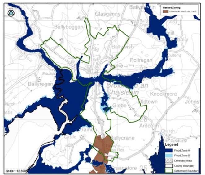
3.3.9 Flood Risk
The SFRA in Volume 11 identifies significant flood risk in Castlebridge, which is related to tidal, fluvial and surface water drainage. The SFRA identifies the following principle flood risk areas in this settlement (See Figure C-1):
- Residential properties along Rectory Walk, the Oldtown Road, and to the rear of Cloisters park, which are partly at risk of flooding.
- There are a number of residential properties surrounding the extensive floodplain which are at risk of flooding.
- At the junction with the R741 in the centre of the settlement there is risk to commercial/industrial sites.
- Undeveloped floodplain is at risk.
- Castlebridge will also be vulnerable to increases in sea levels which will exacerbate flooding in this village.
The SFRA outlines that re-development of any existing property within Flood Zone A/B should be assessed in line with Section 4.7 of the SFRA. Any new development should follow the guidance provided in Sections 4.4 to 4.11. In general the sequential approach should be followed and Flood Zone A/B should be avoided for any highly or less vulnerable development. All future planning applications will be screened for flood risk, and may require the submission of an appropriately detailed site-specific flood risk assessment.
Figure C-1 Flood Risk in Castlebridge
3.3.10 Local Amenities
As noted above the community gardens are an important local amenity. To the south are the Reading Rooms gifted to the community by Guinness. To the west of this is a handball alley. To the rear of Castlebridge House there are community allotments. Further out along the Crossabeg road is a soccer club with modern facilities. Close-by is the former primary school that is in use as a community centre.
3.4 Development Strategy
3.4.1 Strategic Aim and Objectives
Strategic Aim
The Council’s overall aim for the settlement is to improve the local environment particularly for pedestrians walking out from the village core, to facilitate the provision of additional services for the community and to consolidate the development of the settlement to cater for local demand.
3.4.2 Core Strategy Development Approach
As outlined in Section 3.3.1 Castlebridge is designated as a Level 3(a) Settlement in the Core Strategy. The development approach for these settlements, which is set out in the Core Strategy, is summarised here:
- To prepare a Settlement Plan with land use zoning for Castlebridge.
- Focus on moderate population growth;
- Apply the sequential approach to the development of land, requiring residential development to take place within the existing footprint of the settlements. The leap frogging of infill/brownfield lands to undeveloped or greenfield lands will not be considered;
- Promote economic and enterprise development appropriate in scale to the settlements;
- Focus on the regeneration and renewal of these settlements;
- Ensure that new development contributes to the creation of attractive, liveable, well-designed, high quality settlements and that local communities enjoy a high quality of life and well-being;
- Support community organisations who are working to develop community facilities and promote and facilitate initiatives in the public realm.
- Protect and enhance amenities, heritage, green infrastructure and biodiversity in these settlements.
Castlebridge has been allocated 30% population growth for the period 2016-2040.
3.4.3 Settlement Structure and Development
The plan aims to develop a strong and coherent settlement structure. This will be implemented by developing a Place Concept, a Route Concept and a Landscape Concept which builds on the existing places, routes and landscape structures.
3.4.3.1 Place Concept
Castlebridge has developed in a linear form leading out from the village centre. The village core can be defined as being between Freddie’s Shop and the Centra shop, and this area contains the principle retail and small commercial outlets.
The proposals for Place Concept are:
- To consolidate the village centre as the focus for retail and services development;
- To improve the ‘place’ quality of the village centre and the main routes through the settlement along the R741 and the L-3005 leading to Crossabeg. The quality of architecture in these locations will be required to be high to create a sense of arrival to the village;
- To work with the local community to deliver improvements to the public realm in the settlement as resources allow;
- To embrace the estuarine location and natural heritage of the village which are important in defining the place quality of Castlebridge and ensure they are integrated into and respected in future development in the village;
- To improve the legibility and strength of the edges in the main spaces of the settlement and to create a sense of enclosure in accordance with the urban design strategy below and Volume 1 Chapter 5 Design and Place-making in Towns and Villages.
3.4.3.2 Route Concept
The existing route structure is made up of the following:
- The spine of the route structure is the R741 Wexford Road which forms the main street/arterial road through the settlement and the L-3005 link road leading to Crossabeg;
- The two local roads (L-3003 and L-3007) that feeds into the Crossabeg Road on either side of the community gardens which in turn leads to the Wexford Road and this pinch point area provides the only means for both vehicles and pedestrians to traverse the village.
The proposals for Route concept are to:
- Ensure that the routes are designed in accordance with their designated status of Arterial, Link and Local as per Section 5.9 of Volume 1 Chapter 5 Design and Place-making in Towns and Villages and Section 6 of Volume 2 Development Management Manual. In this regard the Regional Road is designated as an Arterial Road and the two local roads are Link routes (in central areas) or Country Roads (see Volume 2 Development Management Manual). Having regard to the prevailing building heights in the village, the building heights shown on the route types will have to be moderated along these routes;
- Ensure that development along the route reflects the ‘movement’ function of the route and the ‘place’ function of the various ‘places’ through which it passes;
- Make retrospective links within the community in consultation with the residents of the settlement;
- Ensure that access is provided to backlands and that no development will prevent an opportunity to make a required link.
3.4.3.3 Landscape Concept
Existing Landscape Structure
The Community Gardens to the south of Castlebridge House and the open space to the south of the Flying Irishman are the main landscape structures within the village. There is a community allotment to the north of Castlebridge House. Other spaces within the village consist of the public open space within residential schemes and fields in between development. The local community have been very active in developing the impressive spaces in the village.
The proposals for the Landscape concept are:
- To work with the local community to deliver improvements to the public open space in the settlement as resources allow;
- Link the various elements that comprise the existing landscape structure to allow for the dispersal of species and improve visual amenity. This will be achieved either through assistance with planting or by requiring green linkages throughout new development to link to other greens spaces and corridors in the village.
3.4.4 Access for All and Age Friendly Development
Whilst there is a younger age profile for Castlebridge and a lower 65 plus age category than the county average as outlined in Section 3.3.2, it is important to future proof development. The future planning of the settlements needs to carefully consider this and the needs of all users, including older people. The Planning Authority will assist developers and local community groups to ensure that this is achieved.
Access for All and Age Friendly Development Objective
It is the objective of the Council:
Objective CB01
3.4.5 Urban Design and Public Realm
As discussed in Volume 1 Chapter 5 Design and Place-making in Towns and Villages, good urban design is a key component of compact growth and place making, ensuring that places are attractive to live, work and visit. In accordance with the Strategy outlined in Section 5.5 of Volume 1 Chapter 5 Design and Place-making in Towns and Villages, key place making objectives for the settlement plan area are to:
- Provide for quality in the design of buildings and places (Quality);
- Ensure that future urban development has a coherent urban structure, is permeable and places people at the heart of the design of streets and public realm (Connected);
- Ensure that future development is compact and rejuvenated (Compact).
- Ensure that the village is vibrant, inclusive, resilient and adaptable.
Urban Design and Public Realm Objectives
It is an objective of the Council:
Objective CB02
Objective CB03
Objective CB04
Objective CB05
Objective CB06
Objective CB07
Objective CB08
Objective CB09
Objective CB10
Objective CB11
3.4.6 Compact Growth
NSO 01 to deliver compact growth will be achieved by prioritising the village centre and main built up area of the settlement of Castlebridge for future growth. This will focus on developing key infill, brownfield sites, under-utilised and vacant sites closest to the village centre first, moving sequentially out from there to the remainder of the existing built-up footprint. This will ensure these sites are reused in the interests of sustainable development and that these sites or premises do not cause dis-amenity to their neighbours or the settlement.
The Planning Authority will also encourage the repurposing and reuse of existing vacant properties in the village centre for appropriate uses to contribute to regeneration and increasing the vibrancy of the plan area. Density and building heights are two key components of compact growth and the appropriate location for increased heights and densities is within or directly adjacent to the village centre as identified above. In accordance with the designated Route Profile as Arterial Route, increased heights will also be considered along the Regional road in more central and at landmark positions.
Compact Growth Objectives
It is the objective of the Council:
Objective CB12
Objective CB13
Objective CB14
Objective CB15
3.4.7 Retail and Commercial Services
The village is served by a relatively small number of retail and commercial services. This is largely due to the close proximity to Wexford Town which provides a much wider range of services. The Council will continue to facilitate the development of retail and commercial services that serve the local community, the rural hinterland and visitors and contribute to a vibrant settlement in the village centre. Such development will be located in accordance with Volume 8 Retail Strategy.
Retail and Commercial Objectives
It is objective of the Council:
Objective CB16
3.4.8 Residential
As set out in the Core Strategy, an additional population of 151 persons is allocated to Castlebridge between 2021-2027. This equates to 103 additional households. It is intended to deliver all of these new dwelling units on lands in a sequential manner within the built-up footprint of the settlement. Proposals relating to the development of accommodation to meet the needs of older people, e.g. nursing homes, retirement villages and sheltered accommodation and the accommodation needs of people with disabilities will be considered on or adjacent to ‘Village Centre’ lands.
Residential Objectives
It is the objective of the Council:
Objective CB17
Objective CB18
3.4.9 Transport and Movement
The R-741 Regional Route serves as a connection between Gorey and Wexford Town, and this route is the main arterial route passing through Castlebridge, on which there are significant volumes of traffic. The L-3005 connects with the R-741 at the centre of the village. This road generates a relatively large volume of traffic given that it connects with Kyle Cross/N11 at the other end, and is a means of avoiding traversing through Wexford Town for passing traffic. The village also generates its own volume of traffic, including pedestrian movements, and the only means of either passing through the village or to traverse within the village is to pass through the short section of road between Freddie’s Shop and the road junction with the R-741, which creates traffic congestion and difficulty for pedestrians to cross.
There are elements of missing footpaths along the roads within the settlement, the most important of which has been identified along the section of road between Elderwood and Roxborough housing estates on the Old Dublin road, south of the village centre.
Since February 2019 an hourly bus service operates to and from Wexford Town operating a ‘Bridge Loop’ service travelling into Wexford via Wexford Bridge and returning to Castlebridge via Ferrycarrig Bridge and Kyle Cross. There are three bus stops presently serving the village, one at the community gardens, one outside the former HSE facility and one located opposite Elderwood housing estate. The latter one is not served by either a footpath or a pedestrian crossing point.
Transport and Movement Objectives
It is the objective of the Council:
Objective CB19
Objective CB20
Objective CB21
Objective CB22
Objective CB23
Objective CB24
3.4.10 Surface Water and Flooding
As noted in Section 3.3.9, there are risks of flooding from tidal, fluvial and surface water drainage sources within the settlement area. Given the very poor drainage characteristics of the area and given that the natural surface water discharge leads to the adjacent natural heritage areas, careful consideration of surface water proposals in accordance with SuDS principles are required to both reduce the risk of flooding and to protect the heritage sites.
Surface Water Objectives
It is an objective of the Council: