Section 1: Bunclody Town Settlement Plan
1.1 Historical Development
The town of Bunclody is situated in the northwest of the county nestled in the foothills of Mount Leinster in an undulating landscape of fertile agricultural land. The River Slaney and River Clody flow through the town and most of the traditional town settlement has developed to its north and west, though some development extends south.
The origins of Bunclody date way back to the famous MacMurrough Kavanaghs when it was a mere hamlet and probably earlier with the suggestion of a former early Christian Carthusian Monastery set up by St Bruno on the site of the current Bunclody Golf & Fishing Club. The town began to evolve and take shape with James Barry raising its status to a post town in 1577 and later it became a planned estate town in the second half of the 18th century by the Maxwell-Barry family, the general form of which is has retained to this day.
Bunclody was named Newtownbarry from 1775-1950. The change from Bunclody to Newtownbarry was made when it became the property in the sixteenth century, of James Barry, progenitor of the Barons of Santry. A poll/vote in the 1950s sought reinstatement of its earlier name and a ballot was conducted by Wexford County Council. The result was subsequently approved by Dáil Éireann and Bunclody was recognised as the official name from January 1st, 1952. Bunclody or Bun Clóidi means ‘bottom of the Clody’ in Irish.
1.2 Urban Structure and Character
The town is very favourably located from an agricultural trade point of view with surrounding lands of superior quality well suited to tillage and arable framing. As a result, Bunclody developed as a market town. The town has predominantly developed around Market Square and along Main Street/The Mall (N80) with subsequent development established off the radial routes extending from Main Street/The Mall. Bunclody town performs an important civic and service function with a concentration of civic amenities including churches and schools. These provide services not only for the resident population but also for a much wider rural and parish based population. The town has retained its planned 18th Century design form and has a strong urban grain with a relatively high concentration of dwellings in a compact area, and services such as pubs, small retailers and local economic activity concentrated along Main Street and around Market Square.
The stone walls, arched bridges, notable architectural heritage and mature trees coupled with views and vistas of Mount Leinster and the River Slaney, create dramatic entrance approaches to the town and a very pleasing environment throughout. The trees and distant hills frame the views into and out of the Mall and Market Square, whilst the corner buildings create a definite entry into the Market Square. The main feature of the town is the cascading stream down the centre of the mall, which is unique in Ireland. The buildings that form Market Square and the Mall are generally three-storey in height and of a formal design in the manner of the 18th Century Georgian or Neo-Classical Townhouses. The corner buildings of the Market Square have hipped roofs, emphasising their location and rendering a sense of enclosure and place. In contrast, the traditional buildings of Church Street, Irish Street and Ryland Road are of a more simple form with an increased use of vernacular elements. The quality of the town’s built heritage is further recognised by the designation of an Architectural Conservation Area.
The area is also one of great natural beauty with the rivers Slaney, Clody and Derry flowing through the parish and the Blackstairs Mountains forming a backdrop. Mt. Leinster [2610ft], the highest in the chain, is situated just above the town of Bunclody. The River Slaney and its associated floodplain is one of the most significant environmental and landscape features of the town.
1.3 Profile
1.3.1 Settlement Hierarchy
Bunclody Town is designated as a Level 3(a) Service Settlement in the Core Strategy Settlement Hierarchy. Level 3(a) settlements are important service settlements for their local communities and their wider rural hinterlands.
The town performs important functions including retail, leisure, hospitality, education, residential, service and amenity functions. The Development Approach for these settlements is set out in the Core Strategy, and is summarised here in Section 1.4.2. The Regional Spatial and Economic Strategy for the Southern Region (RSES) highlights the importance of innovation and the development of networks between towns and villages to complement their more traditional roles.
Bunclody Town was designated as a Rural Economic Development Zone under the Action Plan for Rural Development. It received funding which was used to develop a Town Team comprised of representatives from various businesses, stakeholders, community groups and the Council.
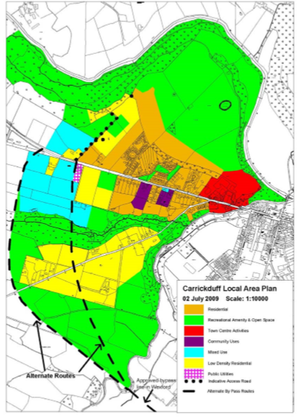
Bunclody sits right on the boundary of County Carlow. Part of the settlement, that is, the area that extends west of the River Clody, is located within County Carlow and accordingly is governed by the policies set out in the Carlow County Development Plan (Carlow CDP). Carrickduff is identified as a Smaller Town in the Settlement Hierarchy of Carlow CDP. The CDP states that although Carrickduff no longer has a statutory plan for the area, the Carrigduff LAP 2009-2015 does contain a significant amount of information on natural and built heritage and other planning issues and that the expired plan will be used as a supplementary guidance document for planning purposes.
Figure B.1 below shows the Land Use Zoning from the Carrickduff LAP 2009-2015.
Figure B.1 Carrickduff Local Area Plan 2009-2015
1.3.2 Population
In Census 2016, the population of Bunclody was 1,984.3 The town has a slightly higher than average cohort of people aged 65 and over at 16.8%. As an Age Friendly county, it is important that the town develops as a safe, accessible, age friendly and socially inclusive settlement, is people friendly and is easy to get around.
1.3.3 Employment
At the time of Census 2016 28% of the labour force in Bunclody was unemployed. This was one of the highest rates in the county and well above the county average of 16.6%. There are high numbers employed in the manufacturing industries at 33.9% of the workforce. Local services including retail, bank, food and hospitality uses also provide local employment.
1.3.4 Deprivation
Bunclody is an attractive town to live and work and has an active commercial centre. However, based on the Pobal HP Deprivation Index – Relative Score 2016 Bunclody is classed as ‘very disadvantaged’. The Wexford Local Economic and Community Plan (LECP) outlines that areas with this level of disadvantage display socio-economic structure weaknesses in the areas of unemployment, education, lone parents and other key demographic indicators, and includes targeted measures to help address disadvantaged areas. The RSES also highlights the need to tackle legacies in areas suffering disadvantage by targeting investment in employment, education, services and amenities in this area. This is supported by the Core Strategy and in related chapters in the Volume 1 Written Statement with a focus on facilitating social and community developments including health services and education and facilitating employment and enterprise developments in disadvantaged areas/unemployment blackspots.
1.3.5 Existing Land Uses
Bunclody Town acts as an important service centre to the settlement and wider rural area.
Retail and commercial services are located primarily in the core retail area of the town, between lower Main Street and upper Main Street with residential extending out from there and some newer retail developments such as ‘Supervalu’ and other retail warehousing and offices located on the Carrigduff side of upper Main Street and Aldi and Mr. Price on Ryland Road (N80), to the south of the town centre. There is also a concentration of other commercial/industrial uses off Ryland Road and out the N80, and also outside the town boundary at locations such as the Slaney Meats factory at Clohamon.
1.3.6 Education
There is one mixed primary school in Bunclody Town. Our Lady of Lourdes National School is located at Hospital Hill and had an enrolment of 268 pupils in 2019/2020. The school site extends to c. 3ha which provides sufficient land to extend the school building and facilities should the need arise. There is also a small mixed primary school in Carrigduff which had an enrolment of 86 pupils in 2019/2020.
There are two mixed post primary schools in Bunclody Town. The FCJ, which is located to the north west of the town, had an enrolment of 934 pupils in 2019/2020. Bunclody Vocational School is located to the southwest of the town and had an enrolment of 219 pupils in 2019/2020.
Traffic congestion and management at the schools can be an issue which needs to be further examined.
Bunclody Vocational School also offers Post Leaving Courses which are open to young people who have completed their Leaving Certificate and adults returning to education. Bunclody Further Education and Training Centre, which is located on the N80, offers Level 4 training in the areas of employment skills and general studies and English for speakers of other languages. These courses provide important skills, focused on those looking to enter/re-enter the workforce.
1.3.7 Infrastructure
There is a public wastewater treatment plant serving Bunclody. As of April 2020 there is ample headroom to accommodate further development.
The area is also served by public water from the Bunclody Water Supply Scheme, and as of April 2020 it too has capacity to accommodate new development.
1.3.8 Vacancy and Under-Utilised Land
There are a few vacant properties in the town centre predominantly on the south side of Market Square. However, this issue is more prevalent along the side streets, in particular Irish St. and to a lesser extent on Church St. where there are a number of vacant and/or under-utilised sites (See Section 1.4.5 below).
1.3.9 Built and Natural Heritage
There are 15 structures listed on the Record of Protected Structures in the settlement of Bunclody as follow:
- WCC0848 Saint Mary’s Church
- WCC0850 Sugar & Spice (Formerly J. Furlong & Company)
- WCC1035 Bank of Ireland
- WCC1037 Former Bunclody Methodist Church
- WCC1038 Former Bunclody Post Office
- WCC1041 Former Allied Irish Bank
- WCC1044 Former RIC Barracks
- WCC0851 Slaney Bridge
- WCC0702 Newtownbarry House
- WCC0717 Slaney Lodge
- WCC1034 Slaney Cottage
- WCC1040 House on Church Street
- WCC1039 Weston House
- WCC1042 Riverview House
- WCC1036 Mill House
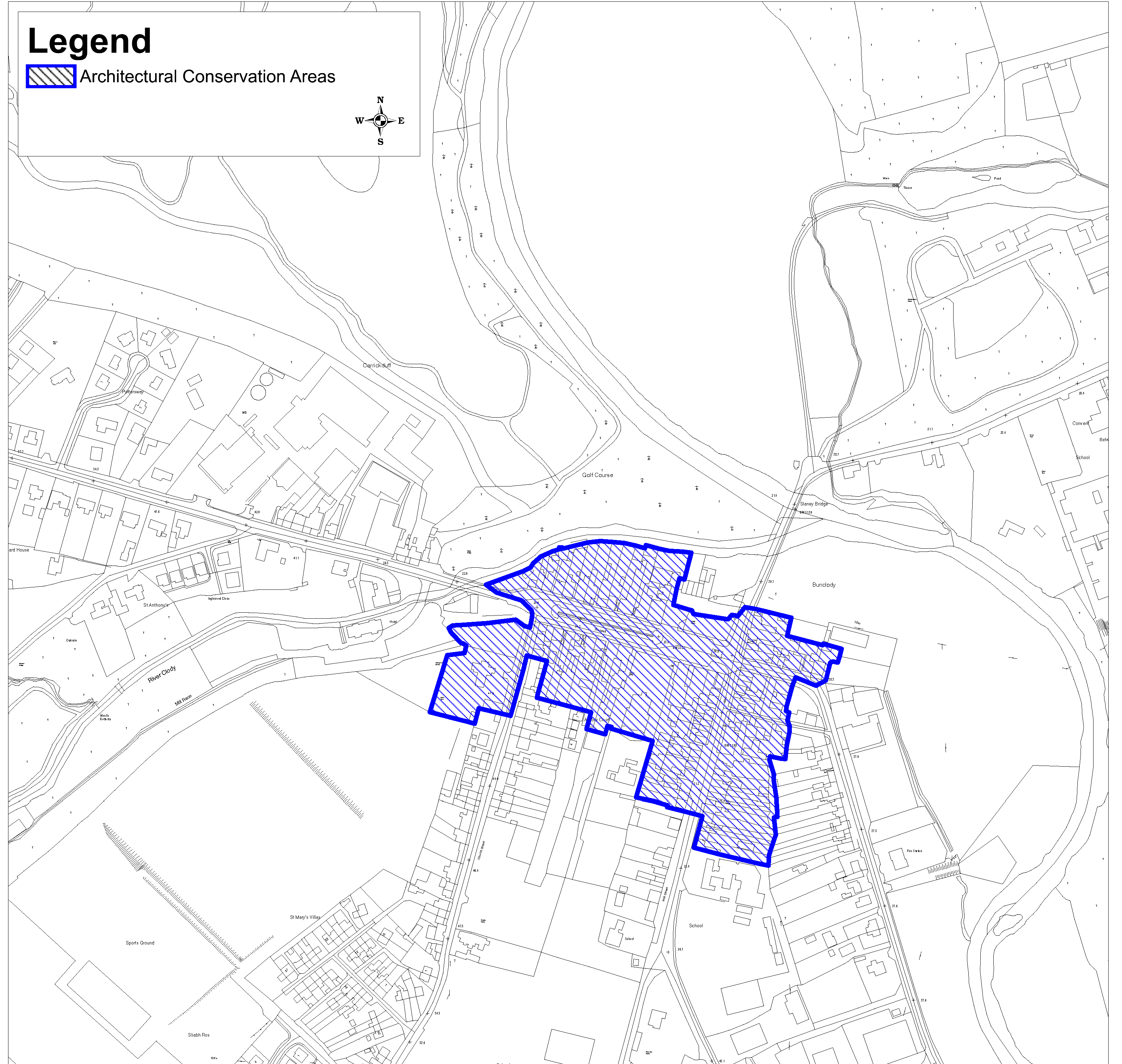
Bunclody Town Centre is designated as an Architectural Conservation Area (ACA) (see Figure B-2 below).
The quality of the town’s built heritage is undoubtedly due to the estate influence, the availability and quality of local building materials and the important market function of the town. The interplay of historic buildings, unique features like the tree lined Mall Stream, the formal urban spaces of the estate village and the urban vernacular streetscapes set within the context of a demesne landscape in the foothills of the Blackstairs Mountains, form the particular character of the area that is unique to Bunclody and warrants protection.
Furthermore the Bunclody ACA contains a visually rich mix of architectural styles within its boundary, ranging from Georgian through to Modern, all of which vary in scale, height, massing and use of materials. Whilst the town has retained its planned 18th Century design form in remarkable condition, the eclectic mix of building styles extending out from The Mall also contributes to the diverse and distinctive built character of Bunclody. See Volume 6 Architectural Conservation Areas for further details.
Figure B.2 Bunclody Architectural Conservation Area
There is just one main site/monument located in/close to the settlement:
- WX009-017 Battlefield at Ballyprecas
Natural features/protections:
Bunclody is located adjacent to a proposed Natural Heritage Area (pNHA) and a candidate Special Area of Conservation (cSAC) Site Code 000781. These contribute to, and are considered fundamental to, the local heritage and attractiveness of Bunclody.
1.3.10 Flood Risk
The town’s development along two rivers has resulted in flood risk to land and buildings, in particular, from the River Slaney along the N80. Flood risk in the town was examined in the Strategic Flood Risk Assessment (SFRA) (See Section 1.4.13 below and Volume 11).
1.4 Development Strategy
1.4.1 Strategic Aim
The aim of the Council for Bunclody Town is:
“To create and sustain a vibrant settlement with a strong sense of place, an attractive public realm, a mix of uses and a high quality residential environment while maximising to the fullest potential the role of Bunclody as a strategic service and employment centre and develop its tourism and leisure potential related to its cultural heritage”.
1.4.2 Core Strategy Development Approach
As outlined in Section 1.3 Bunclody is designated as a Level 3(a) Service Settlement in the Core Strategy. The development approach for these settlements, which is set out in the Core Strategy, is summarised here:
- Focus on moderate population growth.
- Apply the sequential approach to the development of land, requiring residential development to take place within the existing footprint of the settlements. The leap frogging of infill/brownfield lands to undeveloped or greenfield lands will not be considered.
- Promote economic and enterprise development appropriate in scale to the settlements.
- Focus on the regeneration and renewal of these settlements.
- Ensure that new development contributes to the creation of attractive, liveable, well-designed, high quality settlements and the local communities enjoy a high quality of life and well-being.
- Support community organisations who are working to develop community facilities and promote and facilitate initiatives in the public realm.
- Protect and enhance amenities, heritage, green infrastructure and biodiversity in these settlements.
Having regard to the important economic and strategic role of Bunclody it has been allocated 30% population growth for the period 2016-2040.
Additional strategic objectives specific to Bunclody include:
- To ensure flood risk is effectively managed and that vulnerable development is avoided on lands identified at risk of flooding.
- To support the Town Team in its aims and to assist in the development of a comprehensive tourism and leisure package through partnership with the various agencies and the local community including the development of sustainable projects in the area. As part of this package and in order to upgrade the quality of the tourism product, further provision of traditional facilities and accommodation will be encouraged.
1.4.3 Settlement Structure and Development
The Settlement Plan aims to develop a strong and coherent settlement structure. This will be implemented by developing a Place concept, Route concept and Landscape concept which builds on the existing places, routes and landscape structures.
1.4.3.1 Place Concept
Demolition and loss of original structures and building lines can have a detrimental influence/effect on the character and appearance of an area. Where historic street patterns remain, they should be respected, protected and reflected in proposed new development.
The proposals for Place Concept are:
- To consolidate the town centre as the focus for retail and services development.
- To improve the ‘place’ quality of the town centre and along the main routes through the settlement along the N80, Church Street/Mill Road (L-2005), the R746 (Irish Street/Hospital Hill) and the R746 towards Carnew. The quality of architecture in these locations will be required to be high to create a sense of arrival to this unique tourist destination.
- To work with the local community to deliver improvements to the public realm in the settlement as resources allow.
- To ensure the important historic town layout and street pattern is retained in terms of character, fabric, scale, width and alignment.
- To ensure that any new development has strong building lines in the form of a perimeter block therefore creating a strong street edge.
- To improve the legibility and strength of the edges in the main spaces of the settlement and to create a sense of enclosure in accordance with the urban design strategy below and Volume 1 Chapter 5 Design and Place-making in Towns and Villages.
1.4.3.2 Route Concept
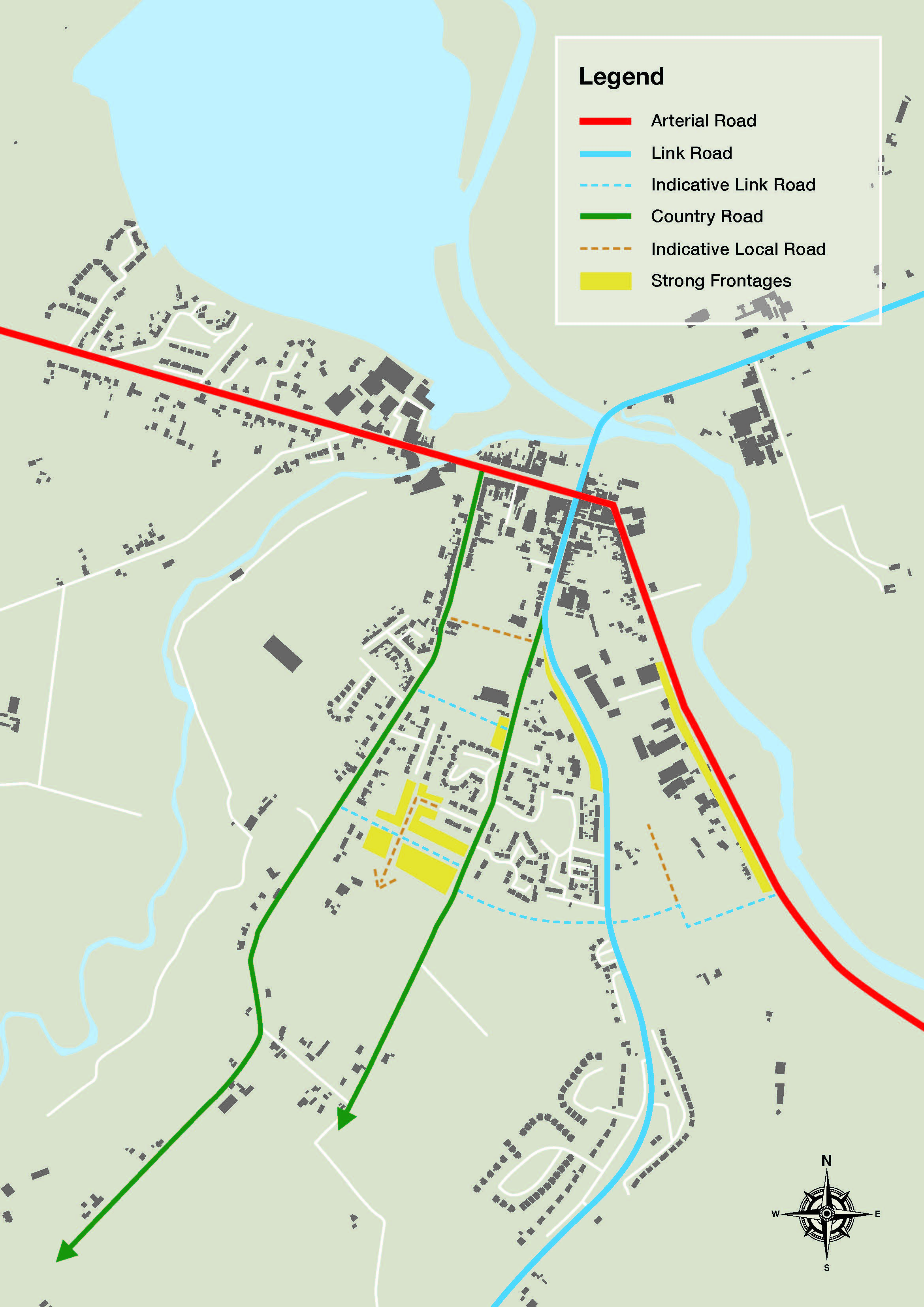
The existing Route Structure as shown on Figure B-3 is made up of the following:
- The spine of the route structure is the N80 National Secondary Road which forms the main access/entry into and through the core of the settlement from the north and south.
- The R746 bisects the Main Street (N80) heading south along Irish Street and through Market Square and over Slaney Bridge heading north towards Carnew.
- Church Street/Mill Road (L-2005) also extends south from Main Street.
Some of the existing estates in the town are either not connected or poorly connected to each other and in some cases, the town centre. As set out above there are three streets/roads which join Main Street - Ryland Road (N80), Church Street/Mill Road (L-2005) and the R746 (Irish Street/Hospital Hill and the R746 towards Carnew). None of these roads are linked which means that someone on Church Street must access any other route from the main N80 route which operates as a one way system either side of the Mall stream.
At peak times, through traffic on the national road (N80) adversely impacts on the amenities of Bunclody town centre and can deter walking and cycling. Congestion also increases journey times on this important national road. The Council will therefore work with Transport Infrastructure Ireland and all other stakeholders in the development and assessment of options, including those relating to the link road and/or a possible by-pass, to address these issues.
The proposals for Route concept as illustrated on Figure B-3 are to:
-
Ensure that the routes are designed in accordance with their designated status of Arterial, Link and Local as per Section 5.9 of Volume 1 Chapter 5 Design and Placemaking in Towns and Villages and Section 6 of Volume 2 Development Management Manual). In this regard, the routes in the town are designated as follows:
- Arterial Route: The N80 which extends north to Carlow and extends south to meet the N11 National Primary Route.
- Link Routes are the R746 and L-2005, which both link to the Arterial Route.
- Local Routes: These are the routes which provide access within communities and link Arterial and Link Routes. The remaining streets and lanes in the settlement plan area are included in this category.
- Provide links between Mill Road and Irish Street/Hospital Hill (see indicative locations on Figure B-3) as part of any development of these lands.
- Ensure that the indicative road links identified on Figure B-3 are facilitated and these accesses are protected from future development.
- As well as detailed road design and movement function, the type of route will inform the design, building line/frontage, building type, building height, density and landscape treatment (see Volume 2 Development Management Manual). However, having regard to the prevailing heights in the town the buildings heights shown on the route types will likely have to be moderated.
- Ensure that development along the route reflects the ‘movement’ function of the route and the ‘place’ function of the various ‘places’ through which it passes.
- Make retrospective links within the community in consultation with the residents of the settlement.
- Ensure that access is provided to back lands and that no development will prevent an opportunity to make a required link.
Figure B-3 Route Concept
1.4.3.3 Landscape Concept
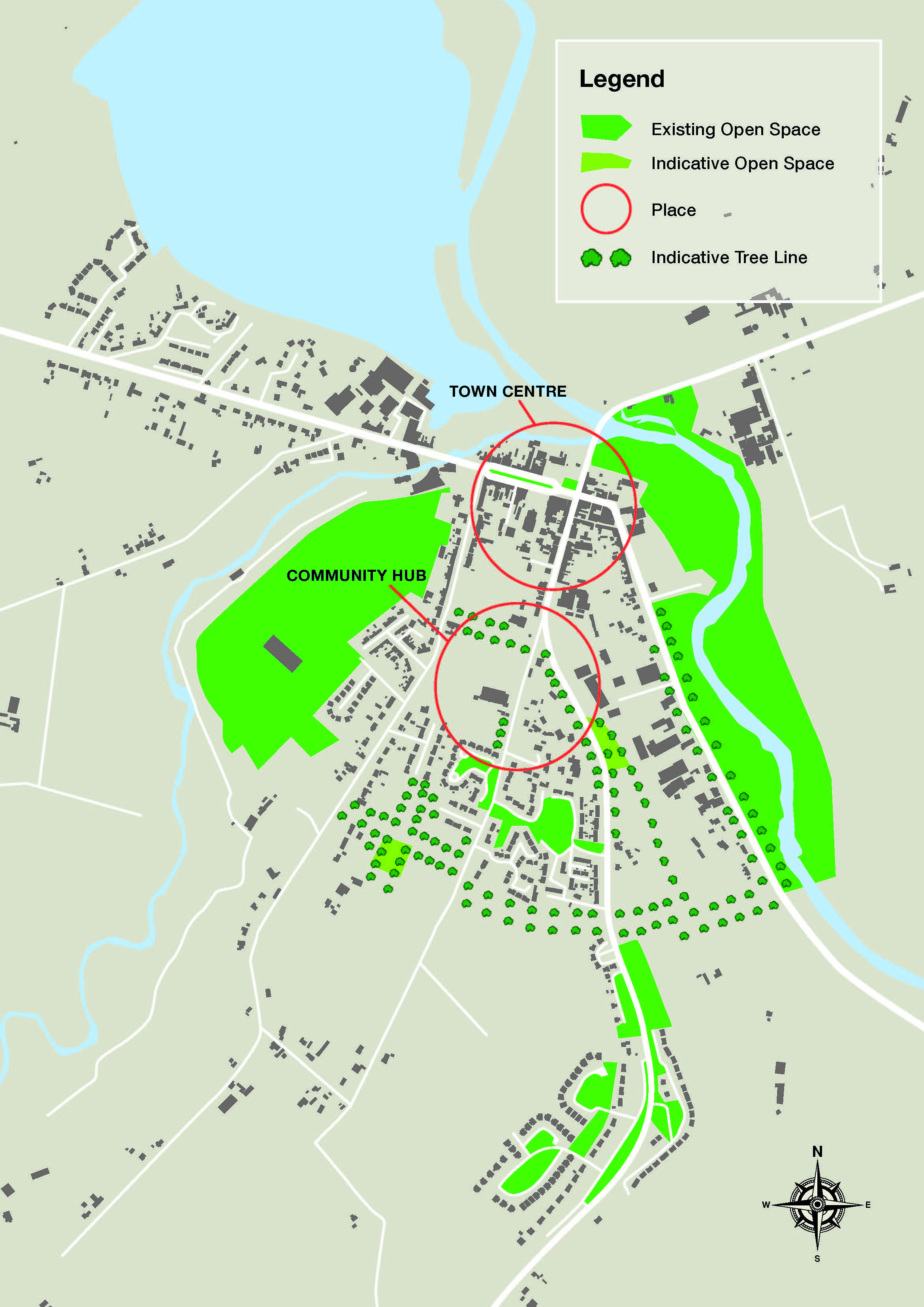
The recent public realm works at Market Square have created a very desirable open space hub in the town. The tree lined stream that flows through Market Square also has amenity value. The Slaney and Clody Rivers and adjoining woodlands to the north of the town centre provide a stunning setting for the village and provide varying degrees of access and offer potential. The mountains and trails adjacent also offer significant amenity and further potential.
The proposals for the Landscape concept (Figure B-4) are:
- To support the community in the implementation of further public realm improvements with the aim of achieving a consistent treatment for landscaping and, in particular, street trees in the settlement to add to coherence.
- Link the various elements that comprise the existing landscape structure to allow for the dispersal of species and improve visual amenity. This will be achieved either through the provisions of planting or by requiring green linkages throughout new development to link to other greens spaces and corridors in the town and wider landscape. The Council will encourage and support the replacement of the removed ‘mile of lime trees’ along the N80 and, where possible, where future road improvements take place in this area.
- River corridors and their associated riparian zones are important for ecological and amenity reasons, flood risk management and water protection as set out in Chapter 11 Landscape and Green Infrastructure in Volume 1. The development of a biodiversity related river walk and/or linear park along the Slaney River and Clody Rivers would be a positive addition to the town which would be supported by the Council. Proposals for development along river corridors and in riparian zones shall have regard to the principles for protecting watercourses as set out in the document ‘Planning for Watercourses in the Urban Environment' (Inland Fisheries Ireland 2020) and any updated version of these Guidelines. It will be necessary to set aside buffer zones with a sufficient area of land along the river corridor.
Figure B-4 Place and Landscape Concept
1.4.4 Access for All and Age Friendly
As discussed in Section 1.3, 16.8% of the settlement’s population was over 65 years old in Census 2016. The future planning of the settlement needs to carefully consider this and the needs of all users, including older people. The Planning Authority will assist developers and local community groups to ensure that this is achieved.
Access for All and Age Friendly Development Objective
It is the objective of the Council:
Objective B1
1.4.5 Urban Design and Public Realm Strategy
The notably urban fabric of Bunclody developed to a large extent in the 18th and 19th centuries and has been largely retained in its 18th Century planned estate town form. The high quality of the town’s built heritage is undoubtedly due to the estate influence and the important market function of the town as well as unique features like the Mall Stream and the presence of high quality local materials and architectural details like the tripartite window which have merited the designation of an Architectural Conservation Area and make the town a very pleasing environment which ought to be protected and enhanced in the most appropriate manner.
As discussed in Volume 1 Chapter 5 Design and Place-making in Towns and Villages, good urban design is a key component of compact growth and place-making, ensuring that places are attractive to live, work and visit. In accordance with the Strategy outlined in Section 5.5 of Chapter 5, key place making objectives for the settlement plan area are to:
- Provide for quality in the design of buildings and places (Quality).
- Ensure that future urban development has a coherent urban structure, is permeable and places people at the heart of the design of streets and the public realm (Connected).
- Ensure that future development is compact and rejuvenated (Compact).
- Ensure that development is vibrant, inclusive, resilient and adaptable.
Urban Design and Public Realm Strategy Objectives
It is the objective of the Council:
Objective B24
Objective B3
Objective B4
Objective B5
Objective B6
Objective B7
Objective B8
Objective B9
Objective B10
Objective B11
Objective B12
Objective B13
Objective B14
1.4.6 Compact Growth
Compact Growth
NSO 01 to deliver compact growth will be achieved by prioritising the town centre in Bunclody for future growth. This will focus on developing key infill, brownfield sites, under-utilised and vacant sites in town centre, moving sequentially out from there to the remainder of the existing built-up footprint. This will ensure these sites are reused in the interests of sustainable development and that these sites or premises do not cause dis-amenity to their neighbours or the settlement.
The following zonings are designated for the purposes of the Urban Regeneration and Housing Act 2015 (as amended):
- Residential - All Residential Zoned Lands (Including Town Centre, Existing Residential and New Residential)
- Regeneration - The lands indicated on Map 1 for Regeneration zoned Town Centre, Commercial and Industrial.
The Planning Authority will encourage the repurposing and reuse of existing vacant properties in the town centre for appropriate uses to contribute to regeneration and increasing the vibrancy of the plan area.
Appropriate density and building heights are two key components of compact growth which will assist with delivery of compact growth, and the efficient use of land.
The Urban Development and Building Heights Guidelines outline that prevailing building heights have a critical role to play in addressing the delivery of more compact growth in our urban areas. The prevailing building height in the settlement plan area is two-storey with three-storeys predominantly along The Mall. The former Mill Race Hotel development (recently converted to Nursing Home) is higher but is somewhat isolated from the core of the settlement and is predominantly sited on the Carlow side of the settlement and is outside the historic boundary and ACA.
Buildings taller than the prevailing heights will be required to have a high quality design treatment and comply with the objectives of Volume 1 Chapter 5 Design and Place-making in Towns and Villages, Volume 2 Development Management Manual and the Urban Development and Building Heights - Guidelines for Planning Authorities (Department of Housing, Planning and Local Government, 2018) and should not impact on the special character and setting of the ACA.
Compact Growth Objectives
It is the objective of the Council:
Objective B15
Objective B16
Objective B17
- Adverse effects on existing amenities in such areas, in particular as a result of the ruinous or neglected condition of any land;
- Urban blight and decay;
- Anti-social behaviour; or
- A shortage of habitable houses or of land suitable for residential use or a mixture of residential and other uses.
Objective B18
Objective B19
Objective B20
Objective B21
Objective B22
1.4.7 Retail and Commercial Services
The settlement is well served by a range of retail and commercial services which includes supermarkets, convenience shops, post office, banks, hairdressers and beauticians, pharmacies, clothing and other comparison goods shops, fuel station, cafés and restaurants, a tourist office and art gallery. The Council will continue to facilitate the development of retail and commercial services that serve the local community, the rural hinterland and visitors and contribute to vibrant settlements. Such development will be located in accordance with the Land Use zoning and Volume 8 County Retail Strategy.
Retail and Commercial Objectives
It is objective of the Council:
Objective B23
Objective B24
Objective B25
Objective B26
Objective B27
1.4.8 Residential
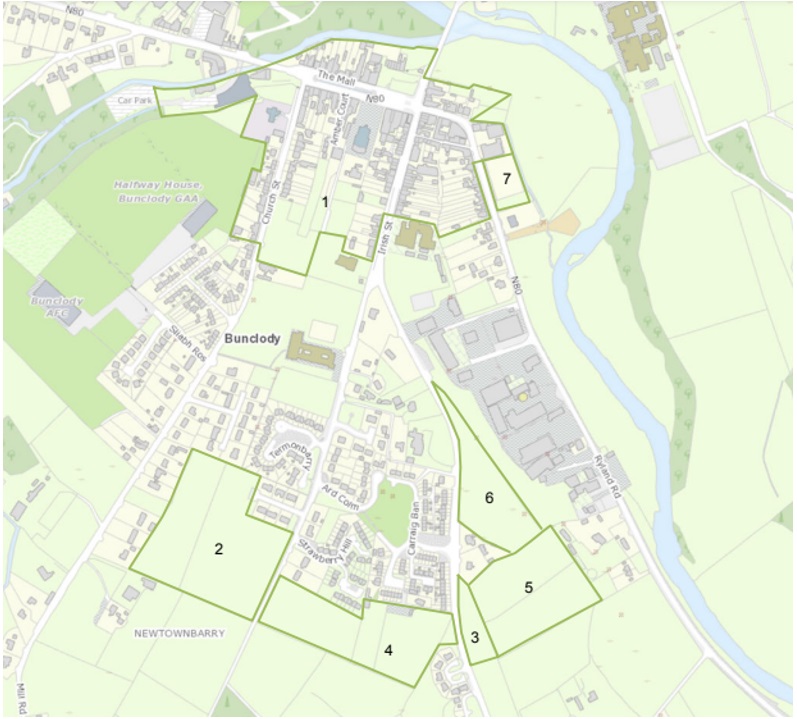
As set out in the Core Strategy, a population growth of 195 persons is allocated to Bunclody between 2021-2027. This equates to 133 additional households. At the allocated density of 25 units/ha this translates to 5.32ha of residential land. However, 6.09ha have been zoned for development during the plan period as Parcel A will be required to deliver a link road and Parcel D has a configuration which may reduce yield.
A tiered approach to zoning has been applied:
- Tier 1 lands are considered fully serviced/‘ready-to-go’ and are positioned within the existing built-up footprint.
- Tier 2 lands are not currently sufficiently serviced to support additional development but have the potential to become fully serviced during the lifetime of the plan.
The residential zoned lands have been prioritised for development based on a number of factors including the planned levels of growth in the town, the achievement of compact growth, the application of the sequential approach, the location of the lands, availability of and proximity to amenities, schools, shops or employment, accessibility to transport services etc and the availability of infrastructure (either Tier 1 serviced land or Tier 2 serviceable land).
6.09ha of land is allocated to Phase 1 for delivery during the current plan period. In the event that some or none of these lands come forward for development during the first three years of the plan, i.e., three years from the date of the plan coming into effect, the lands in Phase 2 lands will be considered, in a sequential manner and subject to the infrastructural requirements being addressed.
As the Council must ensure that the Core Strategy figures are complied with and not exceeded, the Council will monitor the number of units granted on these residential zoned lands and the number of those units that have been either commenced or completed. This will be a material consideration in the assessment of subsequent planning applications and will inform the number of units that can be considered in subsequent planning applications (on either Phase 1 or Phase 2 lands).
Table B-1 provides the detail of each plot, their tier designation and allocated phase, their size, zoning, density, potential residential yield and infrastructural requirements. This table should be read in conjunction with Map 1 Land Use Zoning. This table also identifies if the lands are within the existing built-up footprint of the settlement.
It should be noted that the sum of the Phase 1 lands is 6.09ha. However, as Plot A is required to deliver a link road the residential yield will be reduced. The sum of the Phase 2 land is 6.02ha.
Table B-1: Future Residential Development and Delivery Approach
| Parcel I.D | Tier | Phase | Within Existing Built-Up Footprint |
Size (HA) |
Zoning |
Density |
Residential Yield |
Infrastructural Requirements |
| A |
1 |
1 |
Y (30%) |
4.04 |
Residential |
25/ha |
101 |
These lands are served by a footpath and will require a short extension to the foul sewer network from the adjoining development. Lands to be developed as blocks with frontage on all sides and provide for a link road from Hospital Hill to Mill Road. Large open space to be provided at the centre of the site. |
| B |
2 |
1 |
Y (100%) |
0.65 |
Residential |
25 |
16.25 |
The lands will require the provision of a footpath approximately 75m north of the site as well as along the frontage of the site. The land will require an extension to the foul sewer and water network. The lands are to be developed as blocks with frontage onto the regional road and provision for a link road to the south to link to the commercial zoned lands to the rear. |
| C |
2 |
2 | N |
3.26 |
Residential |
25/ha |
81.5 |
The development of these lands will require the development of footpaths outside the site and further down Hospital Hill. It will also require the extension of the foul sewer, water pipes and public lighting on this side of the road. The lands will be required to deliver a link road between Hospital Hill and the R746. |
| D | 1 | 1 |
Y (100%) |
1.4 | Residential | 25/ha | 35 | The site is serviced. The retention of the hedgerow and mature trees to the north and east must be maintained and enhanced as green infrastructure. |
| E | 2 | 2 | N | 2.76 | Residential | 25/ha | 69 | The development of this land is dependent on the development of Plot B including the provision of a footpath approximately 75m north of the site as well as along the frontage of Plot B and an extension to the foul sewer and water network. Plot E lands are to be developed as blocks with frontage onto the Link Road that will traverse the lands. |
Residential Objectives
It is the objective of the Council:
Objective B28
Objective B29
1.4.9 Transport and Movement
There is a need to improve permeability and connectivity in the area, in particular, between Mill Road, Hospital Hill and Ryland Road. This will be achieved by the delivery of a ‘Link Road’, designed in accordance with the Design Manual for Urban Roads and Streets (DMURS) and Section 5.9 of Volume 1 Chapter 5 Design and Place-making in Towns and Villages and Section 6 of Volume 2 Development Management Manual of the CDP. Pedestrian permeability between existing residential schemes would improve connectivity, contribute to improved socialisation, and provide alternatives, and in some cases, shorter walking times/distances to the town centre.
It is the objective of the Council to ensure maximum pedestrian permeability between the Main Street and ancillary areas throughout the town centre. In this regard the pedestrian use of existing archways, lanes and passages, and the development of new non-vehicular linkages between Main Street/The Mall and backland and/or infill development and parking areas will be promoted, particularly where passive overlooking, active frontages, adequate lighting and security can be reasonably achieved. Developers will be required to facilitate such access where possible as part of any development proposal and where appropriate, development design proposals shall provide for further access to adjacent zones of commercial/residential lands in order to facilitate their future access and development.
Transport and Movement Objectives
It is the objective of the Council:
Objective B30
Objective B31
Objective B32
Objective B33
Objective B34
Objective B35
Objective B36
To provide a cycle route, footpath and appropriate street lighting, segregated where possible, from Bunclody to Clohamon on the N80, subject to Appropriate Assessment in accordance with the requirement of the EU Habitats Directive to ensure the protection and preservation of all designated SACs and SPAs.
Objective B37
Objective B38
Objective B39
Objective B40
1.4.10 Economic Development
Future economic and employment uses in the settlement plan area will be focused on the town centre and the commercial and industrial zoned lands along the N80. The undeveloped industrial land is open to a variety of land uses including industry, manufacturing, transport and logistics, and is considered sufficient to fulfil the economic development envisaged during the plan period. However, the Council will keep this under review.
Economic Development Objectives
It is the objective of the Council:
Objective B41
Objective B42
1.4.11 Recreation and Open Space
The provision of recreational facilities and amenities such as open spaces, public seating, footpaths, trails, playing fields, play areas and community halls can enhance well-being, encourage people to be active and promote safe community interaction and socialising. The village ‘green’/park are important amenities in terms of their function as well as their visual appeal.
The Slaney River and Clody River have leisure and amenity potential, e.g. river walks, angling, kayaking. The development of a Slaney River Walk from Bunclody to Enniscorthy could connect with other existing trails such as the Wicklow Way.
Recreation and Open Space Objectives
It is the objective of the Council:
Objective B43
Objective B44
Objective B45
To identify a suitable location for the development of a Neighbourhood Park including a community play area, adult gym and playground close to the town centre.
Objective B46
Objective B47
Objective B48
Objective B49
Objective B50
- Line of Lime trees along The Mall Stream
- Trees in front of Roman Catholic Church
- Tree in Market Square
- Trees at site of St Mary’s Church
1.4.12 Community and Education
In terms of education, there are two primary schools (one in County Carlow) and two post primary schools within the settlement (all are mixed). The post primary schools serve a wide catchment area. The Department of Education and Skills have not identified a need for an additional school.
The Council will continue to support the expansion of education and training services in the town.
A modern library facility serves the settlement. There is an Arts Gallery present and there is also an annual summer arts festival.
Community and Education Objectives
It is the objective of the Council:
Objective B51
Objective B52
Objective B53
Objective B54
1.4.13 Flood Risk Management
The SFRA (Volume 11) contains a detailed assessment of flood risk in the settlement plan area. The assessment is based on the Area For Further Assessment CFRAM mapping produced by the OPW.
Flood risk is predominantly associated with the River Slaney (See Figure B-5). The most significant flood impacts are felt on the N80 on the southern approach to the town where Flood Zone A overlaps with the road and a small amount of existing development. Flood Zone B overlaps with an existing terrace of houses and significant areas of existing commercial and industrial development along this fringe of the town.
It is further noted that there is minimal existing development within Flood Zone A, however the flood extents increase significantly for Flood Zone B which suggests that climate change impacts will be severe.
The SFRA concludes that:
- Small extensions/refurbishment of existing buildings within Flood Zone A and B should consider the advice given in Section 4.7.1 of the SFRA.
- For the commercial and industrial lands adjacent to the N80 that are within Flood Zone B and are within the Regeneration Area the use should be restricted to less vulnerable or water compatible uses and should consider the advice given in Section 4.4 to 4.11 of the SFRA.
- For the small areas of existing commercial development impacted by Flood Zone A then the Development Management Justification Test may need to be applied depending on the intended use.
- All proposed development bordering the flood zones should be subject to an appropriately detailed Flood Risk Assessment (FRA) at the development management stage and must specifically consider future climate change impact. The Council will continue to ensure that all future planning applications in the settlement plan area are screened for flood risk, that site-specific flood risk assessments are submitted where required and that the requirements of the County SFRA (Volume 11), the Flood Risk Management Guidelines and Chapter 9 Infrastructure Strategy (Volume 1), are fully complied with. The land use zoning matrix in Section 1.5 below also addresses flood risk (see Footnote P1/O1).
Flood Risk Management Objectives
It is the objective of the Council:
Objective B55
Objective B56
Figure B-5 Flood Zone Overlaid on the Land Use Zoning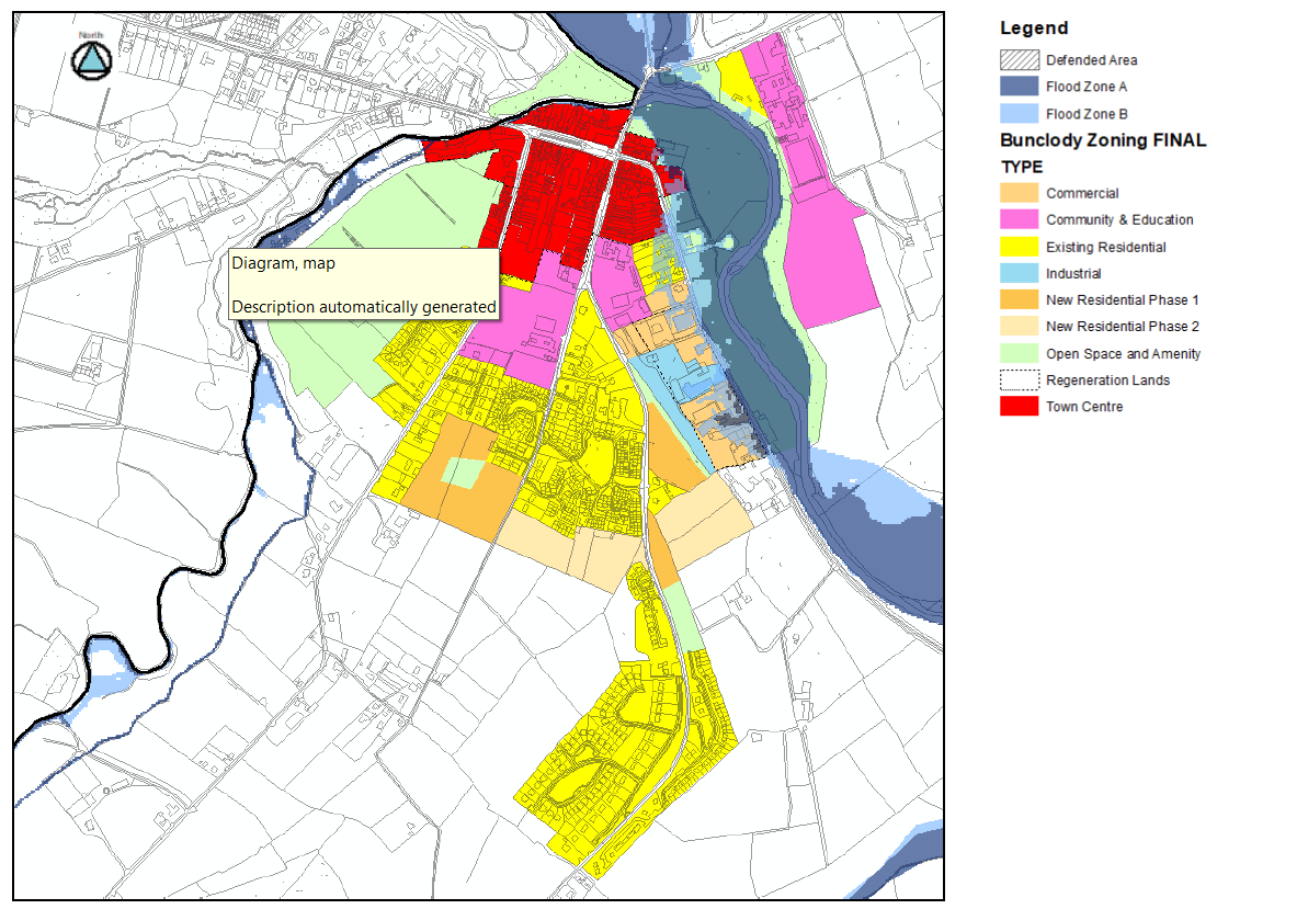
1.5 Land Use Zoning and Matrix
The purpose of land use zoning is to promote the orderly development of the settlement plan area, to establish an efficient basis for investment in public infrastructure and facilities and to avoid potential conflict between opposing land uses. It also identifies for property owners, developers and the public the types of developments and uses that the Planning Authority considers most appropriate on lands within the plan area.
The land use zoning objectives, which are identified on Map 1, have been formulated having regard to the following:
- The existing pattern of development.
- The need to promote the proper planning and sustainable development of the town in line with the Core Strategy in the County Development Plan.
- The need to zone sufficient lands at appropriate locations to accommodate the population allocation and to facilitate economic and enterprise development.
- The protection of the environment and biodiversity and flood risk management.
- The location, accessibility and availability of land for development.
- The existing and future provision of essential infrastructure (water, sewerage and roads) and the need to ensure the efficient use of this infrastructure.
- The location and adequacy of existing social infrastructure (for example schools, childcare facilities and sport facilities).
- The character of the area with regard to the scale and pattern of development.
- The physical features and amenities of the area.
1.5.1 Land Use Zoning Objectives
Existing Residential (ER)
‘To protect and enhance the residential amenity of existing and developed communities’.
This zoning relates to existing residential lands. The purpose of this zoning is to preserve existing residential uses and to provide for infill residential development at a density that is considered suitable to the area. While infill or re-development proposals are acceptable in principle, careful consideration will be given to protecting residential amenities.
New Residential (NR)
‘To provide for new residential development, associated residential services and community services’.
The purpose of this zoning is to provide for new residential development within the existing built-up footprint of the settlement.
Town Centre (TC)
'To provide for an attractive, vibrant town centre which maximises the use of lands and encourages a mix of residential, retail, commercial and civic uses.'
The purpose of this zoning is to enhance the vitality and viability of the town centre through the development of under-utilised and brownfield sites and by encouraging a mix of uses to make the town centre an attractive place to visit, shop and live in.
Community and Education (CE)
‘To protect and provide for community, educational and ecclesiastical facilities’.
The purpose of this zoning is to protect and improve existing community, educational and institutional facilities and to ensure their future provision. Residential uses will not normally be permitted, however this zoning does allow the following to be open for consideration - the development of accommodation for older people (e.g. nursing homes, retirement villages and sheltered accommodation) and the development of accommodation for people with disabilities (e.g. sheltered accommodation and residential care units) where it will be a community, approved voluntary body or public owned nursing home/sheltered accommodation.
Open Space and Amenity (OSA)
‘To protect and provide for recreation, open space and amenity areas’.
The objective of this zoning is to retain and protect all existing open spaces, both passive and active and to facilitate the provision of additional open space and amenity areas. Development that would result in a loss of established open space or lands zoned for open space and amenity will not normally be permitted. An exception may be made to this restriction where compensatory provision is made elsewhere in the town at an appropriate location.
Commercial (C)
‘To provide for a mix of commercial uses’
The purpose of this zoning is to provide for a range of commercial and other uses. It will allow for a mix of business and employment related uses including offices, light industry and warehousing. These lands are located along the N80. The Council will work with local business owners to improve the visual amenities of this area through a number of ways including the rationalisation of signage, improved roadside boundary treatments, tree planting and landscaping. This will improve both the business environment and the approach road into the town.
Industrial (I)
‘To provide for industry and employment’
This land, which is accessed from the N80, provides for the needs of industry and it is envisaged that manufacturing premises, ancillary warehousing and logistics may locate here. It will be necessary to provide for appropriate buffer zones between the lands and adjoining residential properties as part of any future development proposal.
1.5.2 Land Use Zoning Matrix
The land use zoning matrix is intended as a general guideline in assessing the acceptability or otherwise of developments proposed in each zone. This matrix is a guideline and the listed uses are not exhaustive. The indication that a use would be ‘permitted in principle’ or ‘open to consideration’ relates to the acceptability in principle of the use only. Factors such as density, height, traffic generation, environmental factors and design criteria are also of importance in establishing whether or not a development proposal conforms to the proper planning and sustainable development of an area (guidelines and standards on these matters are set out elsewhere in Volume 1 Written Statement and Volume 2 Development Management Manual).
P = Permitted in Principle
A use which is ‘Permitted in Principle’ is generally acceptable subject to complying with the relevant policies, objectives, standards and requirements set out in the LAP and the CDP.
O = Open for Consideration
An ‘Open for Consideration’ use is one which the Council may permit where it is satisfied that the suggested form of development will be compatible with the policies and objectives for the zone, will not conflict with the permitted uses and conforms with the proper planning and sustainable development of the area. Particular attention will be given to the nature and scale of the development when assessing compatibility. When considering whether any given development is appropriate in any zone, the Planning Authority will have regard to the objectives of the CDP.
N= Not Permitted
Development listed as ‘Not Permitted’ in a particular zone will not be permitted for one or more of the following reasons: (i) it may have an undesirable effect on existing and permitted uses, (ii) it may be incompatible with the objectives for the settlement or (iii) it may be inconsistent with the proper planning and sustainable development of the area.
Change of Use and Extensions of Existing Buildings
Change of use and extensions to existing buildings will generally be required to be consistent with the zoning matrix. Exceptions to uses not normally permissible in the zoning matrix will be considered where:
- the Planning Authority is satisfied that the use or extension would not conflict with the land use zoning
- the use or extension would not negatively impact on the amenity of the area
- the use or extension would not give rise to additional planning considerations above those for the existing/previous use.
Land Use Matrix
N Not Permitted, O Open for Consideration, P Permitted in Principle
|
USES |
ER1 |
NR |
TC1 |
CE |
OSA1 |
I1 |
C1 |
|---|---|---|---|---|---|---|---|
|
Agricultural Merchants |
N |
N |
O1 |
N |
N |
N |
O1 |
|
Allotments |
O1 |
O |
N |
O |
O1 |
N |
N |
|
Financial institutions/ facilities |
N |
N |
P1 |
N |
N |
N |
N |
|
Betting office |
N |
N |
O1 |
N |
N |
N |
N |
|
Car park |
O1,2 |
O3 |
P1 |
O2 |
O1,2 |
O1 |
O1 |
|
Childcare facilities crèche/nursery |
O1 |
O3 |
P1 |
P |
N |
O1 |
O1 |
|
Civic amenity/ recycling centre |
O1 |
N |
P1 |
O |
O1 |
P1 |
O1 |
|
Civic buildings |
O1 |
O3 |
P1 |
P |
O1,2 |
O1 |
O1 |
|
Culture, recreation & leisure |
O1 |
O3 |
P1 |
P |
O1,2 |
N |
O1 |
|
Education |
O1 |
N |
P1 |
P |
N |
O1 |
O1,3 |
|
Enterprise centre |
N |
N |
P1 |
O |
N |
O1 |
P1 |
|
Garden centre |
N |
N |
O1 |
N |
N |
N |
O1 |
|
Industry (general) |
N |
N |
N |
N |
N |
O1 |
O1 |
|
Industry (light) |
N |
N |
N |
N |
N |
P1 |
O1 |
|
Hotel |
N |
N |
P1 |
N |
N |
N |
N |
|
Hostel |
N |
N |
P1 |
N |
N |
N |
N |
|
Medical and related consultants |
O1 |
O3 |
P1 |
O |
N |
N |
O1 |
|
Motor sales showroom |
N |
N |
N |
N |
N |
N |
O1 |
|
Nightclub |
N |
N |
O1 |
N |
N |
N |
N |
|
Office |
O1 |
N |
P1 |
N |
N |
O1 |
P1 |
|
Petrol station |
N |
N |
O1 |
N |
N |
N |
O1 |
|
Place of worship |
O1 |
N |
P1 |
P |
N |
N |
N |
|
Public house |
N |
N |
P |
N |
N |
N |
N |
|
Public utilities |
O1 |
O3 |
O1 |
O |
O1,2 |
O1 |
O1 |
|
Residential |
P1 |
P |
P1 |
O4 |
N |
N |
N |
|
Restaurant |
N |
N |
P1 |
O6 |
N |
N |
O1 |
|
Retail (convenience) |
O1,5 |
N |
P1 |
N |
N |
N |
O5 |
|
Retail (comparison) |
N |
N |
O1,5 |
N |
N |
N |
O5 |
|
Retail warehousing bulky goods |
N |
N |
O1,5 |
N |
N |
N |
O5 |
|
Storage/transport depot |
N |
N |
N |
N |
N |
P1 |
O1 |
|
Service garage |
N |
N |
O1 |
N |
N |
O1 |
O1 |
|
Take-away |
N |
N |
O1 |
N |
N |
N |
N |
|
Warehousing |
N |
N |
N |
N |
N |
P1 |
O1 |
|
Waste management facilities7 |
N |
N |
N |
N |
N |
O1 |
N |
Footnotes:
P1/O1 Due to identified flood risk, all future development on ‘Existing Residential’ lands, ‘Town Centre’ lands, ‘Commercial’ 'Industry' and ‘Open Space and Amenity’ lands along the N80 and in the vicinity of the River Slaney and River Clody will be strictly controlled and must comply fully with the requirements of the Flood Risk Management Guidelines for Planning Authorities (DEHLG and OPW, 2009), the County Strategic Flood Risk Assessment contained in Volume 11 of the CDP and Chapter 9 Infrastructure Strategy of Volume 1 Written Statement.
O2 A car park will be considered where it is ancillary to the main use.
O3 This use will only be considered when ancillary to the main residential use on these lands.
O4 Only nursing home/retirement/residential care/sheltered housing type developments will be open for consideration on these lands. It must be a community, publicly owned or developed by an Approved Housing Body.
O5 Subject to compliance with the County Retail Strategy (Volume 8 Retail Strategy of the CDP).
O6 To serve the needs of uses in the zone.
7 Waste management facilities include waste transfer stations, material recovery facilities, waste recovery facilities, waste to energy and authorised treatment facilities for end-of-life vehicles
1.6 Bunclody Infrastructure Assessment Report5
1.6.1 Introduction
This Infrastructural Assessment Report (IAR) has been prepared to inform and accompany the zoning proposals for Bunclody in the Wexford County Development Plan 2021-2027.
The requirement to prepare an IAR is established in the National Planning Framework (NPF), specifically objectives 72a, 72b and 72c with more detailed information within Appendix 3 of the NPF. The overall purpose of the IAR is to make an assessment as to whether the right infrastructural services are available to facilitate the development of zoned land and, if not, to set out if and when infrastructural services deficiencies will be addressed.
The NPF proposes that a tiered approach to categorise lands proposed to be zoned is undertaken, the status of each site being determined by the availability of infrastructural services to service that land. The tiered system is summarised as follows:
Tier 1 Serviced Zoned Lands
Lands which can connect easily to existing infrastructural services in which there is capacity to cater for additional demands placed upon it by development. These lands will generally be located within or immediately contiguous to existing developed lands.
Tier 2 Serviceable Zoned Lands
Lands which are not currently sufficiently serviced but which have the potential to be fully serviced during the life of the Plan. For such lands the IAR should identify if the services can be delivered within the Plan period, the cost of the services (if possible) and the inclusion of the provision of the services in the relevant delivery agency infrastructure investment programme (e.g., Irish Water or Wexford County Council).
Tier 2 lands will also generally be located within or immediately contiguous to existing developed lands.
Appendix 3 of the NPF also implies that there is a further category of zoned land, Tier 3, for land which may not be able to be adequately serviced during the Plan period.
The NPF refers to the future provision of Government Guidelines to local authorities in the preparation of IARs but these Guidelines had not been issued at the time of writing this IAR.
1.6.2 Infrastructural Services
As identified in the NPF, the Infrastructural Services to be assessed in this IAR are roads access, footpath access, street lighting, foul sewer drainage, water supply and surface water drainage.
In the absence of detailed Government Guidance on IAR, Wexford County Council considers that the following minimum standards for infrastructure services should be met to achieve Tier 1 status:
Roads access
The existing road(s) to which the site has frontage should have a minimum carriageway width of 5.5m and the road frontage(s) should have space for a safe access point (having regard to existing speed limits, proximity to junctions etc). If the carriageway width is currently less than this minimum, but the minimum could be achieved through development of the land itself (i.e.by setting back an existing road frontage) then this would be acceptable for Tier 1 status.
Unless the road surface is currently dangerous, then the condition of the road surface is not taken into account.
The road should be capable of safe and convenient use by cyclists.
Footpath Access
There should be an existing footpath on the road from which access can be taken, extending to the frontage of the site and that footpath should form part of the established settlement footpath network to link the site with shops, schools, medical facilities etc. If the footpath is on the opposite side of the road to the site frontage, then consideration shall be given to the speed limit on the road in question, its traffic levels and whether safe pedestrian access can be achieved in the development of the land. The cost of providing a suitably constructed footpath is approximately €100/m (excluding land).
Street Lighting
The road from which pedestrian and vehicular access would be sought should have street lighting extending to the road frontage(s) of the site from where access could be achieved. The street lighting should extend to that of the established settlement. The cost of providing street lighting ( in addition to footpath costs ) is approximately €30/metre.
Wastewater
It should be possible to directly connect the site to the existing foul drainage network at the frontage(s) and there should be sufficient capacity in that pipe. If additional pumping and/or upgraded piping is required off site to facilitate foul sewer drainage and/or if the relevant pumping station requires upgrades, then the site would have Tier 2 status.
The costs of possible upgrades to piping and pumping stations is difficult to quantify at this stage but such works have in the past been funded, to a substantial degree, by the developer of the land benefiting from the upgrade.
Irish Water were not able to provide detailed site-specific information for this IAR. The assessment of wastewater infrastructure contained in this document is therefore based upon Wexford County Council’s best understanding of the current situation.
Water Supply
It should be possible to directly connect the site to the existing water supply network and there should be sufficient capacity in that pipe(s). If additional pumping and/or upgraded piping is required off site to facilitate water supply to the development then the site would have Tier 2 status. The costs of possible upgrades to piping is difficult to quantify at this stage but such works have in the past been funded, to a substantial degree, by the developer of the land benefiting from the upgrade.
Irish Water were not able to provide detailed site-specific information for this IAR. The assessment of water supply infrastructure contained in this document is therefore based upon Wexford County Council’s best understanding of the current situation.
Surface Water Drainage
Surface water management should be possible within the site and it should be possible to directly connect the site to the existing surface water network at the frontage(s). If additional infrastructure is required off site to facilitate surface water drainage, then the site would have Tier 2 status. The costs of possible upgrades are difficult to quantify at this stage.
1.6.3 Existing Infrastructure in Bunclody Town
Roads, Pavements, Street Lighting
Within new developments, roads, pavements and street lighting infrastructure would be expected to comply with the principles, approaches and standards of the Design Manual for Urban Roads and Streets. However, as with many settlements which have developed on an incremental basis over a number of years, much of the existing road and pavement infrastructure in Bunclody would not meet these current standards. Improvements to existing infrastructure are identified as objectives in the Draft Bunclody Town Settlement Plan but for the purposes of this IAR such deficiencies are not used to ‘mark down’ each site which is being assessed. the assessment is based upon whether existing roads, pavements and lighting extend to the frontage of the site, rather than an assessment of whether that infrastructure meets modern standards.
Bunclody Water Supply Scheme
The town’s water supply is currently provided from existing groundwater sources to the west of the town. These feed the Water treatment works at Carrickduff from where it is distributed to the town. The water supply serves a wide area, including the villages of Kilmyshall and Clohamon. Currently there is insufficient capacity to serve the full population allocation for the settlement, however a project is progressing to increase capacity and it is anticipated will be completed within the lifetime of the Plan.
Map 3 gives an approximate indication of the areas in and around the town served by the water supply network.
Map 3 Areas Served by the Existing Public Water Network

Bunclody Waste Water Treatment
Bunclody is served by the existing wastewater treatment plant located on the N80 to the southwest of the town. This treatment plant has a capacity of 6,500 p.e. It currently has a remaining capacity of 3,800 p.e. according to the Irish Water Capacity Study, April 2020.
Map 4 gives an approximate indication of the areas served by the existing waste water network.
Map 4 Areas Served by the Existing Public Waste Water Network

Surface Water
The surface water network around Bunclody is comprised of Wexford County Council managed pipes and discharges and more informal site specific arrangements.
1.6.4 Specific Land/ Sites considered as part of the IAR
The detailed assessment within this IAR is confined to land which is being considered for zoning for new Residential use or Town Centre use (See Map 5). This included land on which submissions were made during the public consultation on the Draft Plan. This also includes lands zoned for Town Centre use which could have a residential component. All of the sites are considered to be within or contingent to the existing built up settlement. It should be noted that the maps used in this IAR are approximate only, to give an indication of the size and shape of the lands concerned. They should not be read as showing site ownership boundaries.
Map 5 Sites Considered in the Infrastructural Assessment Report
Map 6 Site 1
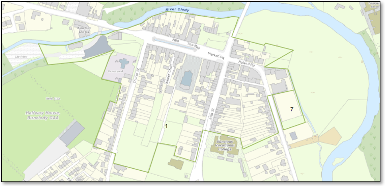
Land within and around the existing town centre, including land which is currently undeveloped, mostly rear gardens on its southern side. The land has a variety of potential residential and commercial uses commensurate with its town centre location. Further residential development would be acceptable in principle on these lands.
There is no footpath currently on the eastern side of Church Street extending south from the town centre but there is a footpath on the western side. The speed limit is 50kph on this road and the Bunclody Town Settlement Plan contains an objective to improve footpath provision on this road. There is street lighting on this road.
Church Street is wide enough to cater for traffic associated with new development and safe access points can be provided. There are also gaps in footpath provision on the eastern and western side of Irish Street, in front of existing development, and the Plan also contains an objective to improve footpath provision on this road. There is street lighting on this road.
There are existing water and wastewater pipes and surface water arrangements in the roads to which this site has frontages.
This site is considered to have Tier 1 status.
Map 7 Site 2
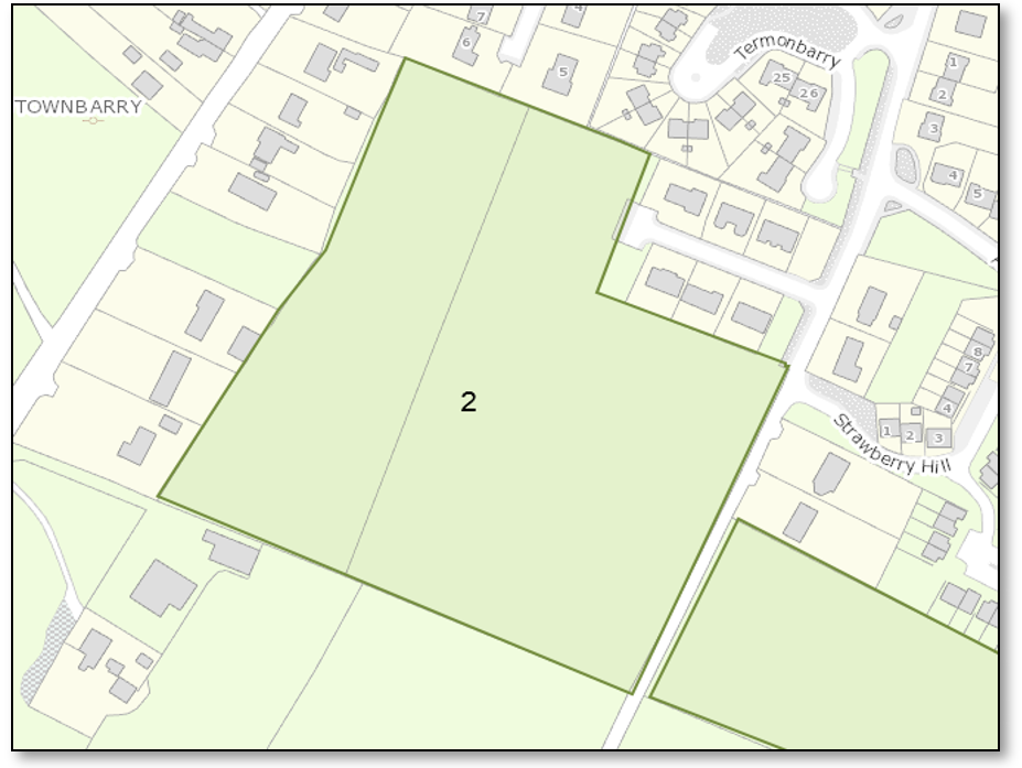
Undeveloped land located at the southern edge of the existing built-up area. Adjoined by residential development to the north, east and west with road frontage to the L-6164 (Hospital Hill) on the east, where there is a 50 km/h speed limit. Land to the south is undeveloped.
Water supply and sewer pipes currently extend to, or are very close to, the frontage of the site, on its north eastern edge.
There is an existing footpath and street lighting on the L-6164 extending to the northern edge of the site. The L-6164 narrows significantly on the site frontage but a redevelopment of the site could relatively easily achieve a safe vehicular access setback to the site frontage or alternatively allow for a cycle path within the development retaining the hedgerow (See Road Profiles in Development Management Manual – Country Road).
The CDP Settlement Plan for Bunclody contains an objective to provide a new link through the site to the L2005 to the west of the site.
Existing surface water management arrangements on the L6164 could be utilised with a development specific surface water management design.
This site is considered to have Tier 1 status.
Map 8 Site 3
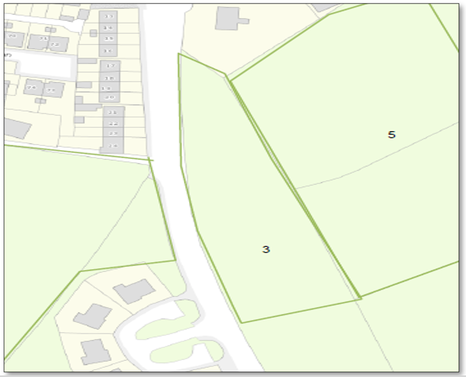
Undeveloped land with frontage to the R746, which has a 60 km/h speed limit at this point.
The land is bounded by undeveloped land to the south and east, with residential development to the north and on the opposite side of the R746 to the west.
It would be possible to form a safe vehicular access from the R746.
There are water supply and sewer pipes on the R746 to which a development of this site could connect to, subject to any upgrades as may be necessary to those pipes.
There is currently no public footpath to the frontage of the site, the closest path being approximately 75m to the north. There is a footpath on the opposite side of the R746, however, notwithstanding its 60 kmh speed limit, this is a regional road with regional road traffic levels and footpath connections to the site frontage would need to be made prior to first occupation of a development. There would be space to construct a footpath on the site frontage without adversely impacting on the road. There is existing street lighting on the opposite side of this road. The cost of 75m of footpath would be approximately €7,500.
The Settlement Plan proposes a new link between the R746 and the N80 across the southern edge of this site from which access could also be taken.
Existing surface water management arrangements on the R746 could be utilised with a development specific surface water management design.
This site is considered to have Tier 2 status.
Map 9 Site 4
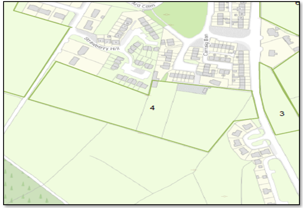
Undeveloped land located at the southern edge of the existing built up area. Adjoined by residential development to the north and south east with road frontage to the L-6164 (with a 50 km/h limit) and R746 (with a 60 km/h limit). Land to the south is undeveloped.
It should be possible to form a safe vehicular access to the site from the L6164 and from the R746.
There are water supply and sewer pipes on the R746 to which a development on this site could connect to subject to any upgrades as may be necessary to those pipes.
There are no water and sewer pipes on the L6164 Hospital Hill on the western frontage of this site.
There is currently no footpath or street lighting on the western Hospital Hill frontage of the site on the L-6164 which would have to be addressed prior to or in tandem with the development of this site. The cost of providing a footpath of approximately 100m in length would be approximately €10000. There is an existing footpath and street lighting on the R746 frontage.
Existing surface water management arrangements on the R746 and L6164 could be utilised with a development specific surface water management design.
The Settlement Plan proposes a new link between the R746 and the L6164 across the site.
This site is considered to have Tier 2 status.
Map 10 Site 5
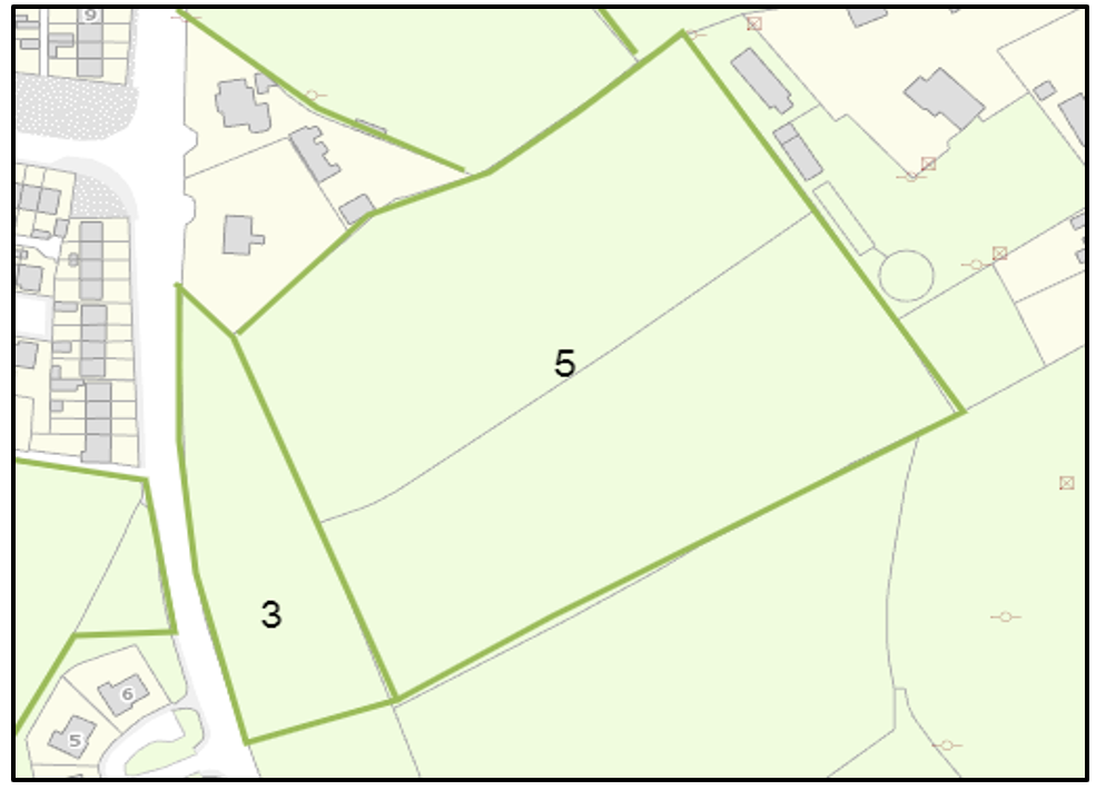
Undeveloped land adjoining the eastern edge of Site 3. The site would need to be developed at the same time as, or accessed via, site 3 and/or a new link, and therefore a similar infrastructure assessment applies.
The site is considered to have Tier 2 status.
Map 11 Site 6
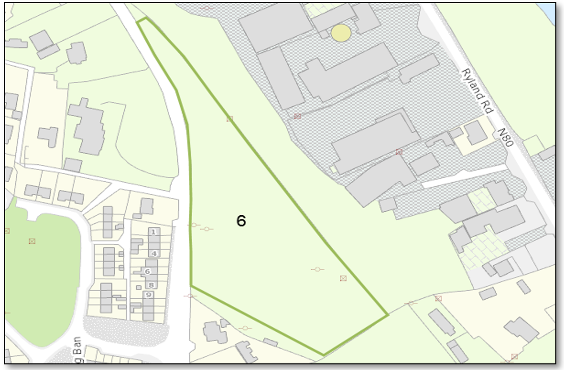
Undeveloped land with a frontage to the R746. A 60km/h speed limit applies at the frontage. The site frontage would be capable of accommodating a safe vehicular access.
There is an existing footpath with street lighting on the frontage of the site. A development could connect to existing water supply and sewer pipes on the R746 subject to any upgrades as may be necessary to those pipes.
Existing surface water management arrangements on the R746 could be utilised with a development specific surface water management design.
The site is considered to have Tier 1 status.
Map 12 Site 7
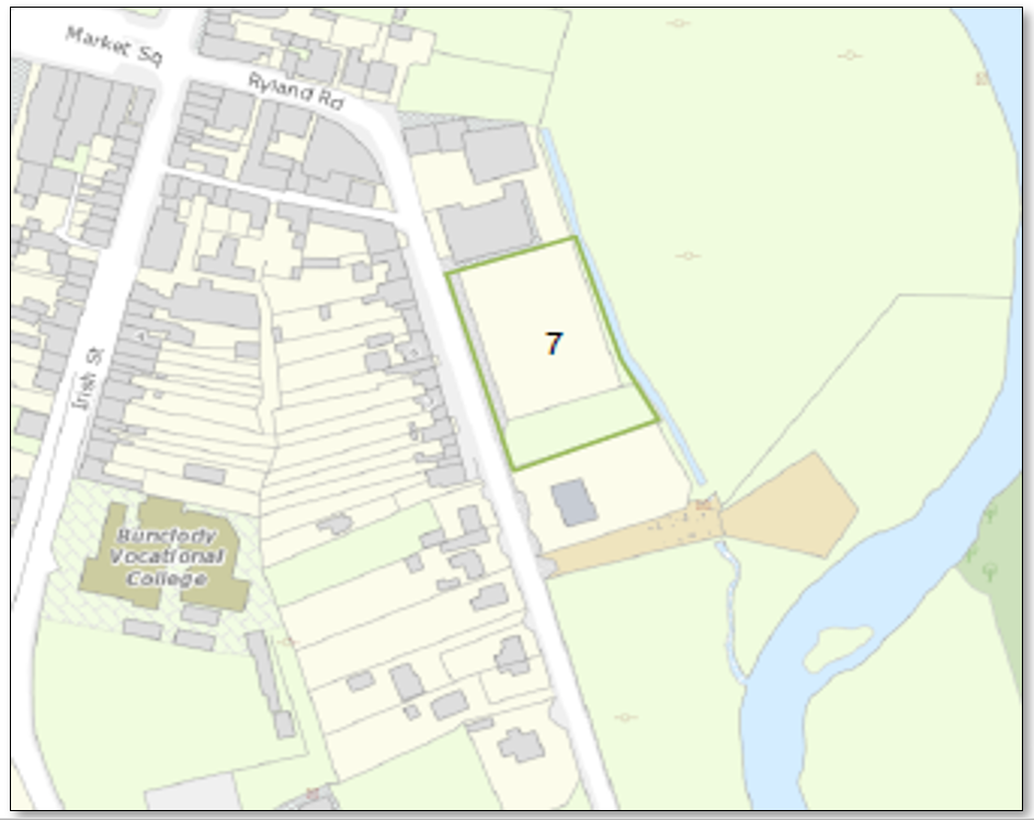
Undeveloped land with frontage to the N80 with a 50 km/h speed limit.
The site frontage would be capable of accommodating a safe vehicular access.
There is no footpath currently on this side of the N80 and the cost providing approximately 40m of footpath to the north to link with the existing would be approximately €4000. There is a footpath with street lighting on the opposite side of the N80.
A development could connect to existing water supply and sewer pipes on the N80 subject to any upgrades as may be necessary to those pipes.
Existing surface water management arrangements on the N80 could be utilised with a development specific surface water management design.
This site is considered to have Tier 2 status.
3 This includes the area within County Carlow.
4 Note the Architectural Conservation Area was formally adopted as part of the Wexford County Development Plan 2022-2028.
5 Note - the map numbering in the IAR continues the map numbering in the Bunclody Town Settlement Plan. Accordingly, the first map number in the IAR will read as Map 5 and will continue from there.