Chapter 8: Transportation Strategy
8.1 Introduction
This chapter sets out the Council’s strategy to provide an effective and sustainable transport system which is accessible to all. An effective transport system is integral to economic competitiveness in the county and improves personal wellbeing. The overall priority in national and regional transport policy is to promote a model shift towards sustainable means (public transport, walking and cycling) and away from outright reliance on the private motor vehicle. While this will prove challenging in a county with such a high number of people living in rural areas the Council is committed to achieving change.
The Council’s role as a Roads Authority means it can promote sustainable transport through its management of the county’s roads network. This includes the provision of footpaths, street lighting, cycling infrastructure, the setting of speed limits, crossings, one-ways systems, pedestrianisation etc. The application of the principles, approaches and standards of the Design Manual for Urban Roads and Streets (Department of Transport, Tourism and Sport and Department of the Environment Community and Local Government, 2013/2019) (hereafter referred to as DMURS/the Manual), is mandatory in the exercise of these functions in towns and villages.
The Council’s role as a Planning Authority means it can promote sustainable transport systems through the integration of land use and transportation, the promotion of compact development to minimise journey length and maximise opportunities to use sustainable modes. It can also ensure that appropriate infrastructure is provided and conducive, attractive and safe streets and transport systems are developed. These elements are further developed in the strategy below.
Significant technological change is likely to emerge in the short and medium term which will impact on transportation issues in the county, e.g. in the provision of electricity and other fuel sources, in digital connectivity and in autonomous vehicles, car and bike sharing etc. The Council must respond in a pro-active and collaborative manner to ensure that the county is ready for, and can fully benefit from, such changes.
8.2 Climate Action and Transportation
Transportation is one of the most significant generators of greenhouse gasses and consumers of energy. In 2017, 19.8% of Ireland’s greenhouse gas emissions were attributable to transport sources. It is therefore one of the sectors with the most potential to mitigate climate change. So important is transport to climate change mitigation that much of the strategy for transport planning (contained in Section 8.4) and land use planning (contained in the Core Strategy and Settlement Plans) stems from the need to replace fossil fuel consumption and associated climate impacts. Transport infrastructure is also vulnerable to climate change, and actions and polices are needed to adapt to such challenges.
Transport considerations are integral to climate change legislation and national, regional and local policy. Section 10 (2) (n). of the Planning and Development Act 2000 (as amended) requires that development plans must include sustainable settlement and transportation strategies in urban and rural areas to reduce energy demand, reduce greenhouse gas emissions and adapt to climate change, in particular in regard to the location, layout and design of new development.
Decarbonising transport is a key element of the National Mitigation Plan (NMP) (Department of Communications, Climate Action and Environment, 2017). The plan includes thirty measures relating to the promotion of sustainable modes of transport, sustainable settlement planning, the use of alternative fuels to diesel and petrol, and the use of intelligent automatic transport systems. The Climate Action Plan to Tackle Climate Breakdown (Department of Communications, Natural Resource and Climate Action, 2019) addresses transport and includes 29 actions relating to alternative fuels, public transport, active travel and emission reduction generally.
The Council’s Climate Change Adaption Strategy was adopted in 2019 and includes transport related goals relating to the integration of land use with transport in development plans, EV infrastructure, and factoring extreme weather resilience in the design and maintenance of transport infrastructure in the county.
The Planning Authority will, inter alia:
- Ensure that land use patterns and transport systems are integrated and that development occurs in a compact manner so that journey distance is reduced and walking, cycling and use of public transport can be maximised.
- Facilitate the shift to new environmentally friendly technology and away from greenhouse gas generating vehicles.
- Integrate green infrastructure and SUDS into existing and new streets and roads.
- Ensure that new transport infrastructure is resilient to climate change and that existing transport infrastructure is protected from the effects of climate change such as increased erosion and increased storminess and storm surges.
8.3 Policy Context
8.3.1 National Transport Policy and Guidelines
NSO 4 of the NPF specifically relates to Sustainable Transport. NSO 1 Compact Growth, NSO 2 Regional Accessibility, NSO 6 High Quality International Connectivity and NSO 8 Transition to a Low Carbon and Climate Resilient Society also relate directly to transportation. The National Development Plan 2018 -2027 sets out of national investment priorities including transport infrastructure. The Department of Transport, Tourism and Sport (DTTS) are currently preparing a ‘Planning and Land Use Transportation Outlook’ which will provide the long term strategy for this investment. This document is expected to be published late in 2020.
‘Smarter Travel – A Sustainable Transport Future 2009-2020’ sets out the Government’s goals to reduce overall demand for travel, maximise efficiency of the transport network, reduce reliance on fossil fuels, reduce emissions and improve access to transport and quality of life. DTTS is currently undertaking a review to produce a policy document to succeed the Smarter Travel 2009-2020 initiative. DTTS and other agencies such as the National Transport Agency (NTA) have issued a range of strategies and guidance relating to sustainable transport including that relating to Alternative Fuels Infrastructure (2017), Permeability (2015), and the National Cycling Manual (2013).
The Programme for Government 2020 contains extensive commitments in support of sustainable transport.
DMURS provides guidance on how the objectives of sustainability may be achieved by design in urban areas. DMURS also contains detailed guidance on designing attractive and safe roads and streets and on technical aspects including sightlines within the 60kmh zone. Outside of the 60kmh zone guidance on sightlines is provided in Rural Road Link Design; Geometric Design of Junctions 2017/2019.
The Spatial Planning and National Roads - Guidelines for Planning Authorities (2012) provide guidance on how national roads should be dealt with in development plans, local area plans and planning applications. Other guidelines directly related to transport include Area Based Transport Assessment - Guidance Notes (Transport Infrastructure Ireland (TII), 2018) which deal with the assessment of traffic generation resulting from specific types of development and locations, the Traffic and Transport Assessment Guidelines (TII, 2014) and the guidance on Road Safety Audits (TII 2017).
8.3.2 Draft Marine Planning Framework
The Draft Marine Planning Framework contains policies and objectives relating the function and development of the Country’s ports and harbours and marine transport, including Rosslare Europort.
8.3.3 Regional Spatial and Economic Strategy for the Southern Region
Transport considerations are integral to the RSES. Strategy Statement 4 for the region is ‘Transforming our transport systems towards well-functioning, sustainable integrated public transport, walking and cycling and electric vehicles.’ Chapter 6 of the RSES addresses digital and physical connectivity, and includes a Regional Transport Strategy. The Strategy has 36 RPOs including those relating to international connectivity (RPO 139, RPO 140), preparation of Regional Freight Strategy (RPO141), Ports (RPO 142-RPO 147), the integration of planning and transport (RPO 151, RPO 154) and a range of policies and actions for local authorities under local planning objectives (RPO 152).
RPO 157 requires local authorities to prepare Local Transport Plans for key settlements based on the Area Based Transport Assessment (ABTA) Guidance Notes produced by TII and NTA. RPO 158 commits to seeking investment for intra-regional rural connectivity including rural public transport which are seen as ‘life lines’ and RPO159 seeks investment to ensure that transportation networks are accessible to all and are socially inclusive. RPO 160 contains ten sub-objectives relating to Smart and Sustainable mobility and RPO 163 relates to Sustainable Mobility Targets and requires local authorities to set targets for modal shift in their development plans. RPO 176 introduces the concept of the ‘10-minute town’ whereby a range of services and uses are accessible in short walking and cycling distances from homes or are accessible by high quality public transport.
Of particular relevance to County Wexford, the RSES contains policies and objectives which promote an Eastern Economic Corridor (EEC). Key Enabler Number 1 of the RSES is ‘Connecting our Region – enhanced infrastructure from North to South and East Coast to West Coast, connecting to the Atlantic Economic Corridor and developing an extended Eastern Economic Corridor to Rosslare Europort’. The EEC is further developed throughout the strategy including objectives RPO 30 (Drivers of Growth), Section 4.4 Economic Engines and RP O42 (Economic Growth), RPO 140 (International Connectivity) and RPO 166 (Investment in Multi-modal Connectivity). The RSES also contains extensive referencing and support for Rosslare Europort including RPO146 and the achievement of Tier 1 status for the Port (RPO 142). Specific strategic road and rail improvements and projects in County Wexford are also supported in the Strategy.
8.4 Sustainable Transport Strategy
8.4.1 Goal
The goal of the Council is to reduce overall travel demand and achieve a modal shift through land use planning, optimising opportunities to make sustainable travel choices, providing a high quality transport network and system which is effective, accessible and responsive to technological change and to reduce the contribution of transport to climate change.
8.4.2 Strategy:
The Council will achieve its goal through the following key measures:
- Reducing demand for travel by integrating land use planning and transport planning and ensuring that new development is compact and connected and located in proximity to existing services and employers and/or at locations with the highest levels of accessibility for public transport and optimises the potential for sustainable modes such as walking and cycling.
- Prioritising sustainable modes of transport such as walking and cycling by ensuring that the development of our towns and villages and the respective route networks are designed in a manner which is permeable, attractive and safe for those users.
- Reducing the carbon generated by the movement of people and goods by prioritising the development of appropriate infrastructure such as public transport, rail freight, cycle paths, electric vehicles etc.
- Ensuring that international, national and regional connectivity is developed to adequately serve the needs of the people and economy and ensuring that transport infrastructure and services for all modes of travel is enhanced on the Eastern Economic Corridor from Belfast to Dublin to Rosslare Europort including Gorey, Enniscorthy and Wexford.
- Preparing Local Transport Plans for the towns of Wexford, Gorey, Enniscorthy and New Ross.
- Setting standards to ensure that development takes place in a manner which is efficient, sustainable, safe and universally accessible and requiring that infrastructure is incorporated in new developments to accommodate alternative fuels to diesel and petrol.
- Responding in a pro-active and collaborative matter to ensure that the county is ready for, and can fully benefit from, technological changes in transport including in the provision of Electric and other alternative fuels infrastructure.
The sections and objectives in this chapter have generally been laid out in terms of user categories (public transport etc.) or infrastructure type, however in many cases these users occupy the same space on both the strategic network and at street level. Therefore, the strategic elements of the network, the achievement of a modal shift on all routes and the design of urban roads and streets are briefly dealt with before the individual users and infrastructures type.
8.4.3 Our Transport Network
Effective connectivity to, from and within the county is essential if County Wexford is to retain and strengthen its economic competitiveness, ability to attract inward investment and its attractiveness as a tourism destination. The Council is committed to enhancing the county’s international, national, regional and local connectivity.
The network hierarchy is comprised of our key international and national routes, including elements of the Trans European Network (TEN-T), our intra-regional routes, our intra-county regional and county routes and our urban roads and streets. Wexford also has the significant advantage of having a connection to the UK and continental Europe via Rosslare Europort and it has a port at New Ross Town for handing bulk liquids and a number of harbours throughout the county. The Council is currently adding to our sustainable network through the development of a series of greenways, trails and blueways.
Figure 8-1 illustrates the strategic elements of the route network of County Wexford. These are the primary routes for travel out of the county, between the main towns in the county and cross sea travel. On these routes there are multiple elements, e.g. at the top of the hierarchy, the TEN-T network contains roads, rail and ports and multiple users/uses such as cars, public transport and freight. At this level in the hierarchy the ‘movement function’ of the route is critical.
Figure 8-1 Strategic Transportation Network
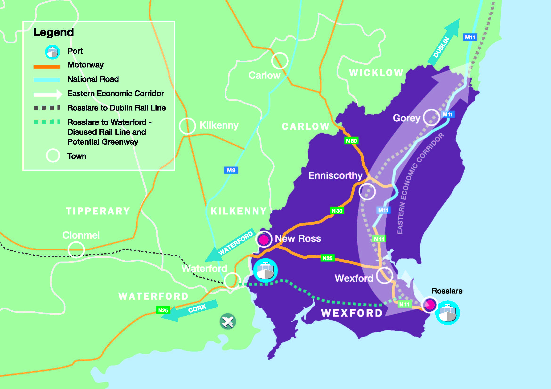
The development of both the transport and economic functions of the EEC is seen as crucial to balanced regional development in both the RSES for the Southern Region and that of the Eastern and Midlands Region. The corridor extends from Belfast to Rosslare Harbour via Dublin, Wicklow, Gorey, Enniscorthy and Wexford towns. The RSES for the Southern Region mentions that the EEC links to New Ross and onward to the rest of the Southern Region completing the connection to the Atlantic Economic Corridor in the west.
At the other end of the hierarchy, urban roads and streets accommodate pedestrians, cyclists, public transport and cars. On these routes the ‘place’ function of the route becomes more important as we try to create conditions to encourage use of sustainable modes and attractive environments. This element of the network offers the most potential to positively influence travel behaviour and create opportunities to facilitate sustainable transport choices while at the same time making attractive places to live and visit.
In order to ensure that land use and transport is appropriately planned for at this level, the RSES introduced a requirement to prepare Local Transport Plans (LTPs) for Key Towns and main settlements. LTPs will assess existing and potential transport systems and networks in the towns to inform Council decision making on zoning, future transport networks and infrastructure investment.
8.4.4 Modal Shift
The benefits to society as a whole associated with this shift include:
- Reduced adverse environmental impacts from emissions including greenhouse gases.
- Physical and mental health benefits associated with walking and cycling.
- Town and village environments which are safer, quieter, and more attractive generally.
- Benefits for economic competitiveness from reduced congestion.
Achieving a major modal shift to more sustainable transport modes will be a substantial challenge, given that the county has and will continue to have a significant proportion of its population living in areas where it is difficult to undertake many journeys by public transport or by walking or cycling. In such areas many people are reliant on private cars. Business activity will also continue to be heavily dependent on private vehicular transport. Notwithstanding this, the Council believes that progress in promoting sustainable transport throughout the whole county can and must be made, however incremental in the short term, and this chapter sets out the objectives through which this may be achieved in rural as well as urban areas.
RPO 163 of the RSES reflects existing and emerging national policy in proposing that targets are set in development plans, local area plans and local transport plans to increase the share of journeys undertaken by sustainable transport.
Achieving significant modal shift is dependent on a wide range of factors, much of which is outside the remit of the Council such as national economic performance, Government investment in sustainable transport infrastructure and school and private bus service provision. Notwithstanding this, Tables 8-1 to 8-10 contain ambitious targets for travel to work and to school. These targets will be reviewed as part of the LTP process for the four main towns.
Table 8-1 Travel to Work - County Aggregate (%)
|
Year |
Private car/motorbike |
Public transport/ walking/cycling |
|
Baseline 2016 |
93.4 |
6.6 |
|
Target 2027 |
90 |
10 |
Table 8-2 Travel to Work - Wexford Town (%)
|
Year |
Private car/motorbike |
Public transport/walking/cycling |
|
Baseline 2016 |
75.6 |
24.4 |
|
Target 2027 |
70 |
30 |
Table 8-3 Travel to Work - Gorey Town (%)
|
Year |
Private car/motorbike |
Public transport/walking/cycling |
|
Baseline 2016 |
76.8 |
23.2 |
|
Target 2027 |
70 |
30 |
Table 8-4 Travel to Work - Enniscorthy Town (%)
|
Year |
Private car/motorbike |
Public transport/walking/cycling |
|
Baseline 2016 |
79.3 |
20.7 |
|
Target 2027 |
70 |
30 |
Table 8-5 Travel to Work - New Ross Town (%)
|
Year |
Private car/motorbike |
Public transport/walking/cycling |
|
Baseline 2016 |
80.7 |
19.3 |
|
Target 2027 |
70 |
30 |
Table 8-6 Travel to School - County Aggregate (%)
|
Year |
Private car/motorbike |
Public transport/walking/cycling |
|
Baseline 2016 |
62.4 |
38.6 |
|
Target 2027 |
55 |
45 |
Table 8-7 Travel to School - Wexford Town (%)
|
Year |
Private car/motorbike |
Public transport/walking/cycling |
|
Baseline 2016 |
57.9 |
42.1 |
|
Target 2027 |
49 |
51 |
Table 8-8 Travel to School - Gorey Town (%)
|
Year |
Private car/motorbike |
Public transport/walking/cycling |
|
Baseline 2016 |
54.5 |
45.5 |
|
Target 2027 |
49 |
51 |
Table 8-9 Travel to School - Enniscorthy Town (%)
|
Year |
Private car/motorbike |
Public transport/walking/cycling |
|
Baseline 2016 |
50 |
50 |
|
Target 2027 |
45 |
55 |
Table 8-10 Travel to School - New Ross Town (%)
|
Year |
Private car/motorbike |
Public transport/walking/cycling |
|
Baseline 2016 |
56.6 |
43.4 |
|
Target 2027 |
49 |
51 |
8.4.5 Design of Urban Roads and Streets
The guidelines set out in DMURS must be applied by the Council in relation to all urban roads and streets, that is, streets and roads with a speed limit of 60 kmh or less1. The Manual recognises the importance of assigning higher priority to pedestrians and cyclists, without unduly compromising vehicle movement in order to create secure, connected places that work for all members of the community. We have moved from thinking of roads as primarily for use by vehicles to places for use and movement of all users in accordance with this prioritisation.
The Manual recognises that a broad range of place-based measures such as built form, landscaping and levels of pedestrian and cyclist activity, as well as more conventional road design measures, will need to be taken into account in designing these roads and streets. New street and road design must put primary emphasis on creating attractive places which are accessible by all and which serve their movement function.
The Manual recognises a hierarchy of routes and sets out the function of the main types of routes (Arterial, Link and Local) and to ensure that they are designed in a manner which will balance their respective ‘movement’ and ‘place’ functions2.
It is vital that roads and streets are designed in a manner which ensures that they can be easily used by all. Road design must consider the ease of movement and safety of all users including wheelchair users, persons with mobility issues, persons with visual impairments, older people and people with pushchairs. The design response may include visual and textured differentiation, use of appropriate gradients and levels and technological solutions. In designing developments it should be ensured that accessibility is considered ‘end to end’, that is, from the door of the accessible dwelling through to parking, street, public realm and destination buildings.
The Manual promotes a design approach which seeks to create self-enforcing low speed environments in urban areas. In terms of road safety, the speed at which drivers travel is principally influenced by the characteristics of the street environment. Integrated design approaches incorporate elements that instinctively alter behaviour thus reducing the need for more conventional measures. The Manual sets out3 a matrix of appropriate design speeds which reflect the road type and context (e.g. local road, town centre or suburban) and user priority. Particular attention must be given to junction design. All junctions must meet DMURS standards and there will be a presumption against roundabouts in favour of standard junctions.
Further detail is provided on the design of street networks, the main types of routes, the design of roads and streets in Chapter 5 Design and Place-making in Towns and Villages and Volume 2 Development Management Manual. Technical information such as the specification for road types, design speeds and surfaces, visibility and splays, alignment curvature and deflections and parking is contained in the Manual and the technical Appendices.
Strategic Transport Objectives
Objective TS01
Objective TS02
- The Core and Settlement Strategy of the Plan;
- Implementation of the 10 Minute Town concept;
- Prioritising the development of lands within or contiguous to the existing urban areas, which are, or will be, most accessible by walking, cycling and public transport;
- Directing larger scale trip intensive developments into locations which are highly accessible by sustainable transport modes and direct uses such as office and retail into central locations ensuring there is integration between various sustainable transport infrastructure, especially in developing connections between active travel, rail and bus; and
- Consolidating and intensifying residential and employment development in a manner which renders it serviceable by public transport and ensures that it is highly accessible by walking, cycling and public transport.
Objective TS03
Objective TS04
Objective TS05
Objective TS06
Objective TS07
Objective TS08
Objective TS09
Objective TS10
Objective TS11
Objective TS12
Objective TS13
Objective TS14
• Consult with the Planning Authority to seek advice on the envisaged route functions in the scheme.
• Assign a ‘route hierarchy’ and ‘route types’ (Arterial, Link, Local) at an early stage in the design process and ensure that the scheme design reflects the respective ‘movement’ and ‘place’ function.
Objective TS15
Objective TS16
- provide safe and convenient infrastructure for walking and cycling.
- ensure that all streets and route networks are designed to balance the needs of place and movement.
- ensure that roads and streets, including their landscaping, street furniture and lighting, function as attractive, fully accessible and safe places.
- passively calm traffic through the creation of self-regulating street environments, particularly in sensitive areas and where vulnerable users are present and to impose speed limits which are reflective of the context and function of the road.
- create roads and street networks which are easily permeable by active travel modes and to support appropriately designed and safe measures which improve the permeability of existing street layouts.
- facilitate accessible, convenient, attractive and user friendly public transport infrastructure in appropriate locations.
- ensure that roads and streets and cycling and walking networks can adapt to climate change and as appropriate can accommodate green infrastructure and biodiversity networks.
Where possible retrofitting modifications of existing roads and streets shall be undertaken to achieve the goals of this objective.
Where amendments or extensions are being proposed to existing schemes they shall also be consistent with the Manual.
Objective TS17
Objective TS18
Objective TS19
Objective TS20
To support the creation of new edge of town transportation hubs connected to the National Bus routes providing park and ride, park and cycle and park and walk transport interchanges for the four main settlements.
Objective TS21
To ensure that new transport infrastructure developed by the Council incorporates appropriate green infrastructure and functions as a biodiversity corridor and ensure that these elements are integrated into the proposals of other transport network providers.
8.5 Walking and Cycling
Walking and cycling are the transport modes which have the least adverse environmental impacts and the most health and public realm benefits for society as a whole. The Council will, in the exercise of its functions in land use planning, development management and the management and provision of road and street infrastructure, facilitate and promote convenient, pleasant and safe walking and cycling in urban and rural areas by:
- promoting compact development in towns and villages at the appropriate locations and at the appropriate density.
- applying the principles, approaches and standards of DMURS and other relevant design Guidance and strategies to facilitate and promote walking and cycling.
- promoting street networks which are fully permeable to pedestrians and cyclists.
- giving full consideration to the needs of pedestrians and cyclists in road and street management measures including the provision of footpaths, street lighting, cycling infrastructure, crossings and the setting of speed limits.
- preparing local transport plans for the four main towns to inform zoning decisions and the development of walking and cycling networks.
- working with significant trip generators such as schools and major employers to improve access by walking and cycling.
The Council will have regard to Government policy and guidance including the Permeability Best Practice Guide (National Transport Authority, 2013), the National Cycle Policy Framework (Department of Transport, Tourism and Sport, 2013) and the National Cycle Manual (Department of Transport, Tourism and Sport, 2011) and any updated or new policy or guidance issued during the life of this Plan.
Improvements in e-bike technology has the potential to encourage more cycling, particularly in the hillier parts of the county. The Council supports the Toolkit for School Travel (Department of Transport, Tourism and Sport, National Transport Authority, Green Schools/ An Taisce, 2013 ) which promotes cycling and walking for trips to school and will seek to provide and facilitate the provision of safe routes to school.
Both walking and cycling are popular fitness / leisure activities and have the potential to deliver tourism growth. The Council supports the Get Ireland Walking Strategy (Sports Ireland) and other initiatives such as Slí Na Slainte, and has been proactive in developing the Eurovelo cycling route which follows the Norman Way heritage route. The Council has also been at the forefront of cycling safety with the ‘Stayin’ Alive at 1.5’ campaign.
Greenways facilitate walkers and cyclists and the completion of the N/M11 and N25 national road schemes may allow opportunities for the provision of safe cycling and walking on existing national roads to be by-passed. Objectives relating to fitness, leisure and tourism aspects of walking and cycling are included in Chapter 7 Tourism Development and Chapter 14 Recreation and Open Space Strategy.
The Council will prepare strategies for walking and cycling in the county to inform and co-ordinate the development of the necessary accessible infrastructure to facilitate and encourage more walking and cycling for both everyday transport and leisure purposes.
Walking and Cycling Objectives
It is the objective of the Council:
Objective TS22
Objective TS23
Objective TS24
Objective TS25
The design of new developments, streets and street networks shall be in accordance with DMURS and the TII document ‘Treatment of Transition Zones to Towns and Villages on National Roads’ where relevant and shall recognise the importance of assigning higher priority to pedestrians and cyclists and ensure that they are fully permeable by pedestrians and cyclists. Where practical, new developments should integrate fully with existing roads and streets to facilitate permeability. Proposed modifications to existing roads and streets shall also have regard to these guidance documents. Scheme designs shall also have regard to the Permeability Best Practice Guide (NTA, 2015), other Government guidance and advice as may be updated, Chapter 5 of this Plan and the development management guidance in Volume 2.
Objective TS26
Objective TS27
Objective TS28
Objective TS29
To provide cycling and walking routes as resources allow within and between settlements, and between settlements and rural trip generators (including places of employment, sports facilities, tourism assets including greenways and other amenities). The Council will provide a cycle way, segregated where possible, between County Wicklow, Gorey, Camolin, Ferns and Enniscorthy, with a view to extending this cycle way towards Rosslare Europort and New Ross. The provision of such cycling and walking routes shall be subject to the protection of habitats, environment, amenity and heritage and Appropriate Assessment in accordance with the requirement of the EU Habitats Directive to ensure the protection and preservation of all designated SACs and SPAs. Green infrastructure and sustainable drainage shall be designed into such routes where possible.
Objective TS30
To support the work of schools and community groups in the development of initiatives which facilitate and encourage walking and cycling.
8.6 Public Transport
The availability of public transport is critical to reduce per capita carbon emissions by minimising the number of individual car-based journeys. It is also an essential service for people who do not have access to a private car. The provision of public transport services is critical to the sustainable development of smaller towns, villages and rural areas and to regional, national and international connectivity.
The Council does not directly provide public transport services but can influence the effectiveness, viability, attractiveness and sustainability of bus, rail and taxi services through:
- ensuring that development takes place in locations which can be served by existing and potential new public transport networks.
- ensuring that land in proximity to existing and potential public transport facilities and routes is developed to an optimum scale and density so that enhanced public transport services are viable.
- enabling the necessary infrastructure for users and operators of public transport and protecting public transport infrastructure from development which may impede its future use and development.
- planning for the integration of public transport services and networks with other means of transport.
Public transport considerations will be central to the local transport plans,which will be informed by consultations with operators and will examine existing and possible future public transport provision and required infrastructure.
The DTTS Sustainable Mobility Review (2020) is examining future government transport policy in Ireland, including public transport provision in rural areas. The Council will act where it can to implement any policy changes, guidance and actions which emerge from this review.
8.6.1 Rail
Rail travel can have significant advantages as a sustainable transport mode. However, ineffective infrastructure and operations combined with the comparative ease of using road based passenger or freight journeys, has meant that the use of rail services in the county has been in long term decline.
The Rosslare – Dublin line is currently the only operating rail route in the county. The Rail Review 2016 Report (NTA, 2016) suggested that part of the line, including that between Gorey and Rosslare, was not financially viable in the long term. However, the Council considers that the review did not address the potential of the line to meet future travel demands or sustainable transport policy objectives which have been significantly strengthened in the more recent NPF and Climate Action strategies. The line is also a key element of the EEC and has the potential to perform an enhanced role in the development of sustainable tourism growth in the county. The Council will therefore continue to resist any proposals to further reduce or close services on any part of the line and will work to support ideas and proposals which would enhance its potential for growth in use.
The RSES supports the use of disused railway lines as greenways but requires that the use of the Rosslare-Waterford line does not prejudice the reintroduction of rail services on the line due to the important role it plays in connecting Rosslare Europort to the rest of the Southern Region. With appropriate upgrades the lines have potential to link significant populations in the south of the county and to carry freight and passengers from Rosslare Europort to the Waterford City Region, the growth of which is envisaged in the NPF.
There is clear potential for freight services to make better use of railway infrastructure. The importance of Rosslare-Europort for the country as a whole is likely to increase as a consequence of the departure of the UK from the European Union. The provision of enhanced rail freight handling infrastructure is supported by the Council as is the proposed Regional Freight Strategy proposed in the RSES.
8.6.2 Bus
There are currently extensive bus services on the Wexford, Enniscorthy and Gorey to Dublin/Dublin airport route, and less frequent inter-county services on other routes, including services to/from New Ross and Bunclody and serving Waterford, Kilkenny and Carlow. Services are provided by both public and private operators.
Bus Éireann, Wexford Bus and Local Link also provide services in rural areas of the county and Wexford Bus provides a town service in Wexford Town.
The Local Link service, funded under the Rural Transport Programme, and managed locally on behalf of the National Transport Authority, links many of the smaller settlements and rural areas around the county. The services range from door to door, scheduled weekly, daily and evening services through to full seven day commuter services. The services are contracted to private operators. For rural communities, these services provide access to urban services and play a vital role in addressing social isolation.
There is a network of school bus services serving rural areas in the county and these services help to reduce congestion from private vehicle use for drop-off and collection.
8.6.3 Taxi
The Council acknowledges and supports the role of taxis as a flexible public transport service. Taxi services are vital for the many people who may not have ready access to private cars and for the evening economy.
8.6.4 Park and Ride
Park and ride facilities provide an opportunity to act as a bridge between private cars and public transport and have the potential to reduce congestion in central areas and wasteful use of central areas for parking. They are of particular use for people who cannot make the first part of their journey by public transport due to remoteness or scheduling of services. They can accommodate both commuters and shoppers whose journey may originate within the specific towns or people from rural areas.
8.6.5 Transport Sharing
Car and bike/scooter sharing services form part of the public transport system in other towns and cities nationally and internationally and the Council will work with operators to enable the possible future establishment and effective management of such services.
Public Transport Objectives
It is the objective of the Council:
Objective TS31
Objective TS32
Objective TS33
Objective TS34
- Facilitate universal access;
- Promote the effectiveness and viability of services;
- Promote the convenience and attractiveness of public transport for all sections of the community;
- Allow for efficient integration between different transport modes;
- Connect key locations such as tourism assets, leisure and recreational destinations; and
- Provide appropriate and sensitive parking and infrastructure for all modes at tourism and amenity sites.
Objective TS35
Objective TS36
Objective TS37
- The protection of lands adjacent to railway lines and stations against encroachment by inappropriate uses that could compromise the long-term development of the rail facility
- Prohibiting development that would impact on the safe operation of current and future rail services.
Objective TS38
- Improvements to the line’s infrastructure which would result in increases to the frequency and speed of services;
- Electrification of the service;
- The provision or re-opening of new stations in the county;
- Better integration with other transport modes, including integration with any expanded DART and LUAS services in South Dublin / County Wicklow;
- Works which improve passenger comfort, convenience and accessibility; and
- Works to reduce the risk of coastal erosion and other damage affecting the viability of the line.
Objective TS39
Objective TS40
Objective TS41
8.7 Roads
The Council recognises that, while other forms of transport perform better in terms of sustainability and carbon emissions, an effective road network for cars and commercial vehicles is essential. The county’s rural populations and businesses will continue to be significantly reliant on private vehicular transport and the road network.
In towns and villages, in order to optimise the environmental and social benefits from a modal shift towards walking, cycling and public transport, the Council will apply the principles, approaches and standards of DMURS10 in the management of the road and streets network, and will give consideration to other measures influencing the use of motor vehicles including reviews of existing and proposed parking provision, restricting car access on certain streets by cars and the possible designation of low emission zones as referred to in the Climate Action Plan. In this regard however, the Council will be conscious of the need to avoid creating significant traffic congestion, to avoid undue adverse impacts on residents and businesses and to facilitate appropriate access for people with disabilities.
Local transport plans will include assessments of the effectiveness of the existing road network and may recommend that appropriately designed new road links are provided, where such links would also facilitate sustainable transport modes and would contribute to improved permeability, emissions reduction and improve place making.
The Council has established an EV working group and will work with developers and relevant infrastructure providers to ensure that the residents and businesses of the county can successfully switch from petrol and diesel fuel sources as envisaged in national policy.
The recent completion of the N25 New Ross by-pass, the M11 Gorey to Enniscorthy to Oilgate and the N30 Enniscorthy to Davidstown have significantly improved inter-connectivity with the rest of the Southern region and the country as a whole, including for bus services. Gorey, Enniscorthy and New Ross should greatly benefit from the diversion of through-traffic and greater opportunity now exists for improvements to the public realm and for sustainable transportation in these towns. Facilitating better national road access to Rosslare Europort for freight and other traffic is also of great importance to the economy of the county, region and country as a whole and such improved access should also reduce the social, environmental and financial costs of congestion affecting settlements on the current route.
On national, regional and local roads and in towns and villages, the Council will facilitate and carry out work that will improve the safety, efficiency and, where appropriate, capacity of the network. The Council supports the principles and aspirations of the Road Safety Strategy 2013-2020 (Road Safety Authority, 2013) and will implement the recommendations of a new Road Safety Strategy to be prepared by the RSA in 2021 to succeed the 2013-2020 strategy.
Traffic and Transport Assessments (TTA), including mobility management plans, will be sought, where necessary, to inform planning decisions on developments which have the potential to create significant additional demands on the road network. Road Safety Impact Assessments (RSIA) and Road Safety Audits (RSA) shall also be sought where appropriate to inform planning decisions (see Section 8.10 of this chapter). The application of DMURS in road design will also control speed by altering driver behaviour using built form and road and street layout.
The Council will ensure that the road network is designed to balance the needs of all users, placing pedestrians, cyclists and public transport at the top of the hierarchy of users. In this regard, the Council will ensure as far as reasonably possible that future roundabouts are ‘Dutch-style’ roundabouts with priority cycle lanes and pedestrian ways.
The NMP promotes the use of alternative fuels to diesel and petrol to reduce overall carbon emissions and improve air quality. The Government policy document ‘Alternative Fuels Infrastructure for Transport in Ireland 2017 to 2030’ (Department of Transport, Tourism and Sport, 2017) sets out measures to achieve the necessary infrastructure to facilitate the use of these fuels. Many of the alternative fuel sources could use existing infrastructure (e.g. at existing petrol filling stations).
General Roads Objectives
It is the objective the Council:
Objective TS42
Objective TS43
Objective TS44
Objective TS45
Objective TS46
Objective TS47
- the nature and location of the development;
- priority for sustainable transport choices including public transport, walking and cycling;
- effective surface water management;
- amenity of adjoining uses; and
- Volume 2 Development Management Manual
Objective TS48
To require the provision of electricity charging infrastructure for electric vehicles in new developments and on existing streets and to facilitate charging infrastructure on existing roads and streets, buildings, car-parks and at tourism sites in positions which give due consideration to other users of pavements and roads.
Objective TS49
To ensure all new car parks and expansion of car parks provide 20% of the spaces with electric vehicle charging points and provide culverts and infrastructure to “drop in” new charging points.
Objective TS50
Objective TS51
Objective TS52
Objective TS53
- Spatial Planning and National Roads, Guidelines for Planning Authorities (Department of Environment Community and Local Government, 2012);
- the National Roads Authority’s policy statement on the Provision of Tourist and Leisure Signage on National Roads (March 2011); and
- any updated versions of these documents.
Objective TS54
To ensure that the requirements of the Environmental Noise Regulations SI 140 of 2006 and the objectives of Wexford County Council’s Noise Action Plan (2019) are taken account of in the assessment of relevant planning applications, and zoning of land and that appropriate noise mitigation measures are incorporated into development design.
Objective TS55
To encourage the use of road corridors, including national road corridors as green infrastructure networks and to encourage roads infrastructure design which maximises opportunities for biodiversity.
Objective TS56
8.7.1 National Roads
Transport Infrastructure Ireland (TII) has overall responsibility for the future development and the operation of the national road network. The Council will continue to work with TII to support major improvements to the national road network and to maintain and protect the safety, capacity and efficiency of national roads and associated junctions in accordance with the Spatial Planning and National Roads: Guidelines for Planning Authorities, (Department of Environment Community and Local Government, 2012).The M/N11 and N25 are important roads for the country and region as a whole and are part of the Pan-European comprehensive TEN-T network. The completion of the M11 Gorey-Enniscorthy-Oilgate Scheme and N25 New Ross By-Pass scheme in 2019 and 2020 has reduced inter-regional journey times and will bring other economic and social benefits to the county.
8.7.1.1 National Roads Projects
Oilgate to Rosslare Harbour
The improvement of road linkages to Rosslare Europort is supported in the NPF, the National Development Plan 2018-2027, the National Marine Planning Framework and the RSES for the Southern Region.
Following an option selection process which assessed possible route options against Economic, Safety, Environmental, Accessibility and Social Inclusion, Integration and Physical Activity criteria, and examined multi-modal scheme options and alternatives, a preferred scheme option corridor was selected and published in June 2021. Following detailed scheme design and the completion of environmental and appropriate assessment processes, it is anticipated the scheme could proceed through the statutory planning processes in 2023.
N25 Rosslare Europort Access Road
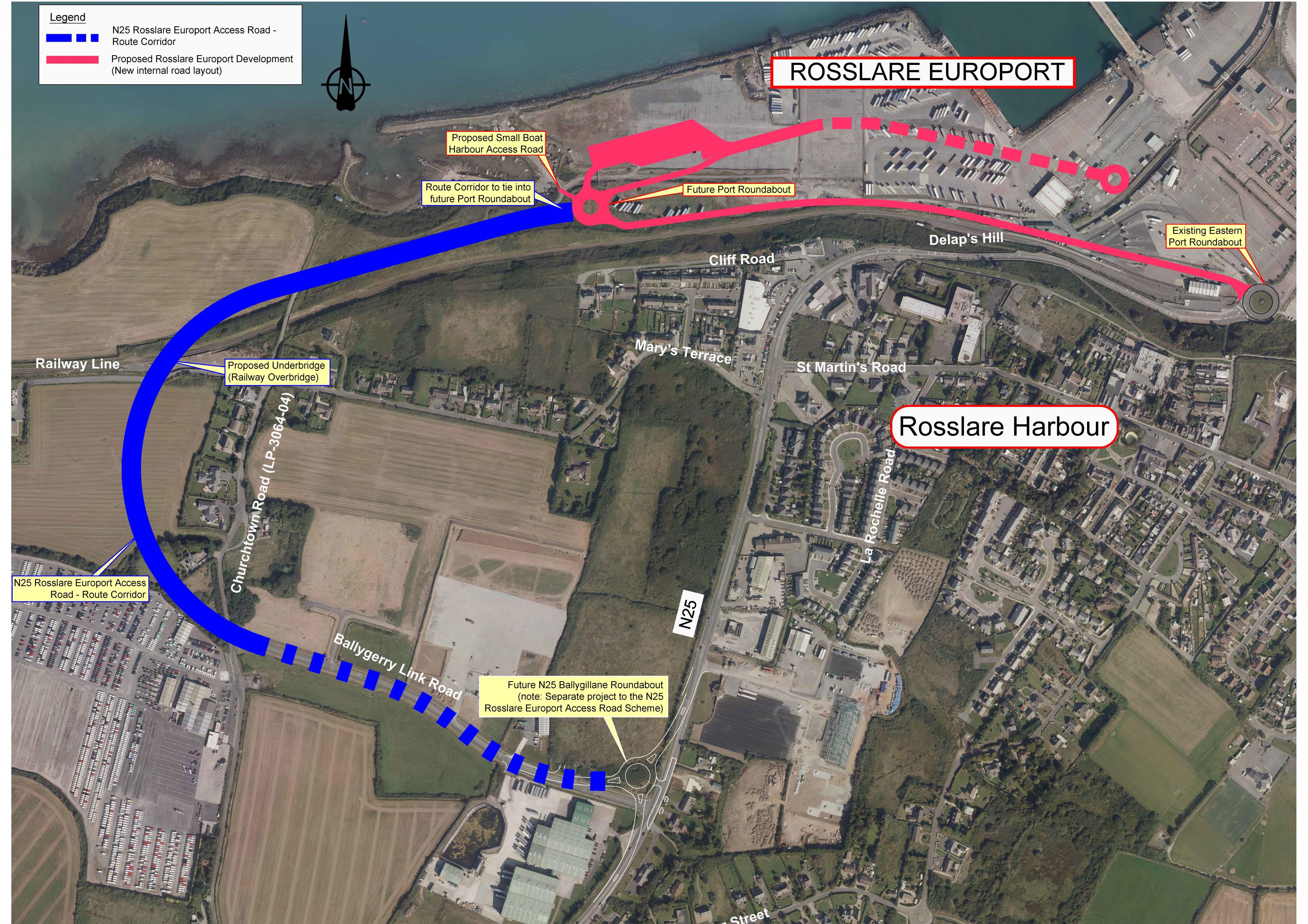
The development of the access road to Rosslare Europort and associated linkages is part of the critical infrastructure required for the port to grow and also deal with the continuing changes required as a result of the UK leaving the European Union. The consent process is likely to be advanced ahead of the Oilgate to Rosslare project to enable improved freight access to the port.
Following the completion of Phase 2 (Option Selection), the Council has confirmed the scheme option. The chosen option combines the construction of a new offline access road to the port and the upgrade of the existing Ballygerry Link Road as shown in blue in Figure 8.2. The design and environmental assessment of the proposed scheme will then proceed, and it is anticipated that the project could proceed through the statutory planning processes by 2022. Separately, the ‘N25 Ballygillane Roundabout’ scheme received Part 8 Planning approval in January 2020. That project will provide a roundabout on the N25 at its junction with the L7021 Link Road. The N25 Rosslare Europort Access Road project will be developed to fully integrate with the approved N25 Ballygillane Roundabout scheme, and the approved Rosslare Europort Masterplan development (shown in red in Figure 8.2).
Figure 8.2 N25 Rosslare Europort Access Road Scheme Option
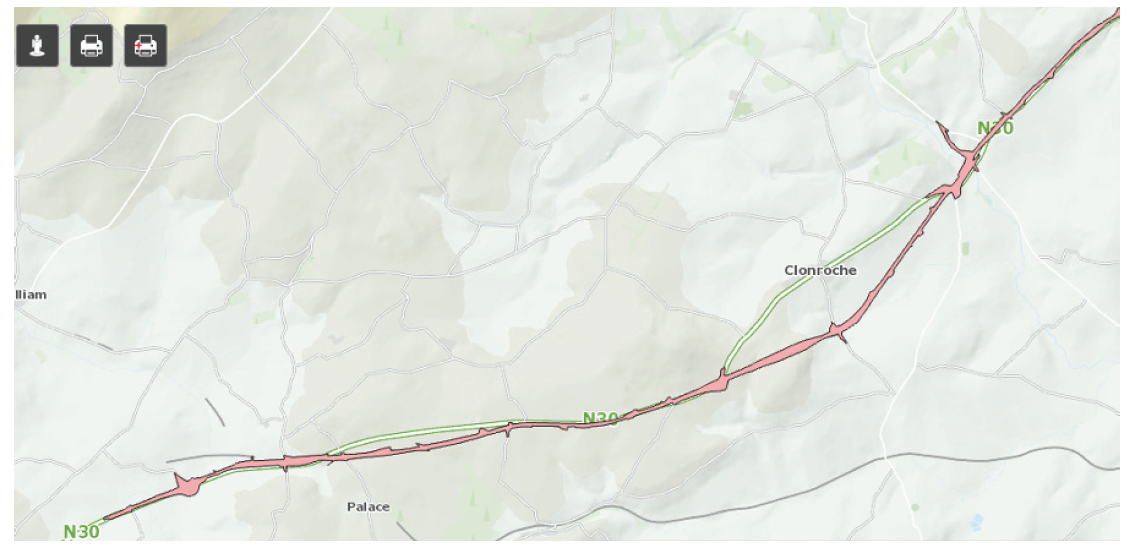
N30 Clonroche By-pass
The N30 Clonroche By-pass has been fully approved and although no works are currently scheduled the route corridor will be protected from development which may compromise its future construction (see Figure 8-3)
Figure 8-3 N30 Clonroche By-pass Route Corridor National Road Improvements
The Council will support the development of improvement works to the National Road network given the importance of the N25, N30 and N80 in providing access from the Midlands to Rosslare Europort and the wider region to Belview Port.
The RSES and the Council support improvements to the N80 which link the county to the Midlands and improvements to the linkage with the N9 from New Ross (which would largely take place in County Kilkenny) but no works are currently scheduled in this regard.
8.7.1.2 Development and National Roads
In order to protect the safety, carrying capacity and efficiency of the national route network, access, zoning and development proposals (including rural development and housing) which may introduce traffic movements onto national roads and national road junctions, will be strictly controlled, particularly where the speed limit exceeds 60 kmh. An evidence based approach will be used in the assessment of the impacts of development and land use zoning proposals on the safety, capacity and function of national roads (including potential upgrades) and junctions.
The objectives in this chapter that relate to accesses to and proposals which affect national roads have been prepared in accordance with Spatial Planning and National Roads: Guidelines for Planning Authorities, (Department of Environment Community and Local Government, 2012) and Circular 16/2011 issued by the National Roads Authority (now TII).
National Roads Objectives
It is the objective of the Council:
Objective TS57
Objective TS58
Objective TS59
Objective TS60
Objective TS61
Objective TS62
Objective TS63
Objective TS64
- Generally retain required lands free from development including any identified preferred route corridors.
- Require that adjacent development of sensitive uses, such as housing, schools and nursing homes, are compatible with the construction and long-term operation of the national road.
- Ensure that other development objectives, including the zoning of land, do not compromise the route selection process.
- Seek to minimise adverse impacts on local residents and on the natural and built environment.
- Adopt a flexible approach in accordance with the provisions of TII/NRA Circular 16/2011.
Objective TS65
Objective TS66
Category 1
Developments of national and regional importance which by their nature are most appropriately located outside of urban areas, and where the locations concerned have specific characteristics that make them particularly suitable for the development proposed. In considering the appropriateness of making any such exception the Planning Authority will also take the following matters into account:
- The relevance and appropriateness of the proposed development in supporting the aims and objectives of the National Planning Framework and Region Spatial and Economic Strategy for the Southern Region.
- The requirements of other planning guidelines issued under Section 28 of the Act, including the Retail Planning Guidelines (2012) which include a general presumption against large retail centres being located adjacent or close to existing, new or planned national roads, including motorways.
- The nature of the proposed development and the volume of traffic to be generated by it and any implications for the safety, capacity and efficient operation of national roads. Retail or residential development will not be considered under this category.
- Demonstration of satisfactory demand management measures.
- Any plans for future upgrades of national roads and other transport infrastructure/services.
- The suitability of the location compared to alternative locations.
- The pattern of existing development in the area.
-
The precedent that could be created for cumulative development in the area and the consequent implications for the national road network.
The Council will only consider developments of national or regional importance under this category where access is proposed to/from non-motorway and non-dual carriageway national roads. The Council will have regard to whether or not that national road is to be by-passed in its considerations. Such proposals are required to be subject to an evidence base and incorporated into the Development Plan by amendment or variation in accordance with the provisions of the Spatial Planning and National Roads Guidelines (2012) or in exceptional circumstances by Material Contravention of the Plan under Section 34(6) of the Planning and Development Act 2000 (as amended). The Planning Authority will consult with TII and have regard to their advice in all such instances.
Category 2
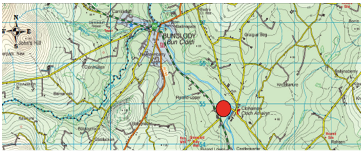
Developments relating to the existing established large enterprise/employer on the national road network at Slaney Meats (N80) which is identified on Figure 8-4.
Figure 8-4 Slaney Meats
Category 3
Developments on lands zoned under the Clonroche Local Area Plan 2009 (as extended), in order to facilitate necessary and orderly development of the village.
In all three categories of such exceptional circumstances:
- It must be demonstrated by the applicant that there is no alternative access point available other than to the national road network at a location where a speed limit greater than 60 kmh applies and that the envisaged usage of the access point will not compromise the safety, capacity and efficient operation of national roads.
- The applicant will be responsible for preparing the required Road Safety Audit and Transport and Traffic Assessment reports. The Council shall use the assessments provided, together with available data, to establish an evidence base. Permission will only be granted where it can be demonstrated that any proposed development does not compromise the safety, capacity and efficiency of the national road network.
- The Council will work with Transport Infrastructure Ireland to review the speed limits in areas where existing employers or existing or proposed zoned land exists with the intention of reducing, where required, the speed limits subject to the appropriate statutory process.
- The applicant will be required to provide details of, and funding for, any capacity enhancements or traffic or demand management measures required.
Objective TS67
Objective TS68
Objective TS69
Objective TS70
To support the development of cycle tracks adjacent to the routes of new road schemes.
Objective TS71
8.7.2 Regional Roads
Regional roads serve a very important function in the county’s transport network by providing direct links capable of accommodating significant traffic levels between towns and villages, serving the rural areas in between, and providing access to national roads. Having regard to these functions and the over-riding public safety imperative, the Council will continue to invest in the maintenance and improvement, where necessary and as resources allow, of the County’s regional roads and will prevent development which would compromise these functions and/or the safety of all road users.
Where regional roads pass through towns and villages the Council will apply the principles, approaches and standards of DMURS to the design and management of the roads and adjoining development.
The Council will strictly control new access points and material intensification of existing access points outside the 60kmh zone in the interests of public safety and to safeguard the functions of, and investment in, regional roads. Accesses will also be controlled between the 50-60kmh zone, where such accesses would undermine the purpose of the transition zone.
The assessment of planning applications for new or materially intensified access points to regional roads will have regard to the speed limit in place on that road and the volume of traffic which that road carries.
Table 8-11 identifies and categorises the regional roads and Objectives TS73 and TS74 set out the criteria to be addressed for each category. These objectives implement a stricter control over the formation of new and the intensification of existing access points on certain regional roads. Objective TS75 and Development Management Manual Policy 6.6 sets out the other criteria to be addressed in the assessment of applications, including the provision of sightlines.
Table 8-11 Regional Roads
|
Class 1 |
Class 2 |
|
R725 Gorey – Carnew |
R700 New Ross – R714 |
|
R733/R770 Wexford - Arthurstown – Ballyhack |
R702 Enniscorthy – Kiltealy |
|
R739 N25 junction - Kilmore Quay |
|
|
R741 Wexford – Gorey |
R729 New Ross-Poulmounty |
|
R772 (former N11) Oilgate – Wexford/Wicklow border |
R730 Wexford – Kiltealy |
|
R723 Ballymacar roundabout - New Ross |
R731Ballynabanogue – Killanne |
|
R714 Mountgarret Bridge to Corcoran’s Cross |
R733 Arthurstown – New Ross |
|
R734 Ballinteskin – Hook Head |
|
|
R735 Gusserane – Clonroche |
|
|
R736 Rosslare –Ballynaboola |
|
|
R737 Haggard –Duncannon |
|
|
R738 Barntown – Baldwinstown |
|
|
R740 N25-Rosslare |
|
|
R742 Wexford – Kilmuckridge – Courtown – Gorey |
|
|
R744 Enniscorthy – Blackwater |
|
|
R745 Ferns – Ballindaggan |
|
|
R746 Wheelagower – Bunclody |
|
|
|
|
Regional Roads Objectives
It is the objective of the Council:
Objective TS72
Objective TS73
To prevent new, or the material intensification of existing, access points to Class 1 regional roads where a speed limit of more than 60kmh applies (see Table 8-11 Regional Roads). This objective will not apply in the following locations and circumstances:
- For farmers, and their sons or daughters12, proposing to build a dwelling house for their own permanent private use, provided that a need for that dwelling has been clearly established and where there is no suitable alternative access/egress possible from the family landholding onto a local road.
- For replacement dwellings.
- The intensification of use of an existing entrance to accommodate the sub-division of the site of an existing authorised dwelling house site to provide a dwelling for the use of a son or daughter of the original site owner, where a need for that dwelling has been clearly established and where there is no suitable alternative access point possible from the family landholding onto a local road. Proposals for granny flat type developments at such properties will be considered on their merits having regard to the characteristics of the site and the anticipated level of intensification of use of the existing access/egress point.
- For developments of a commercial nature, where a clear need for the development is established, which could not be met in other locations, and where there is no suitable alternative access to a local road possible or appropriate.
Planning applications for these types of development shall also be assessed having regard to Objective TS75. This objective also applies where access to the regional road is proposed via an existing private lane.
Objective TS74
These planning applications shall also be assessed having regard to Objective TS75. This objective also applies where access to the regional road is proposed via an existing private lane.
Objective TS75
- The capacity and efficient operation of the regional road at that location. A Traffic and Transport Assessment will be required to be undertaken where appropriate, in accordance with the requirements of Section 8.10.
- Public safety and the need to avoid an undue proliferation of accesses to the regional road at that location. A Road Safety Audit will be required in accordance with the requirements of Section 8.10.
- The promotion of convenient, safe and attractive cycling and walking.
- Compliance with all other relevant objectives and development management standards including those relating to the provision of sightlines.
Objective TS76
- The capacity and efficient operation of the regional road at that location. A Traffic and Transport Assessment will be required to be undertaken where appropriate.
- The characteristics of the site.
- The likely level and characteristics of traffic associated with the development /use proposed.
- Public safety and the need to avoid an undue proliferation of accesses to the regional road at that location; Road Safety Audit may be required to be undertaken where appropriate.
- The Design Manual for Urban Roads and Streets (Department of Transport, Tourism and Sport, 2013/2019) and the promotion of convenient, safe and attractive cycling and walking.
- Compliance with all other relevant objectives and the development management standards of the development plan/local area plan which relate to the lands, including those relating to the provision of sightlines.
8.7.3 Local Roads
Wexford has a comprehensive local road network covering all parts of the county. These roads serve an important function for rural communities and agricultural enterprises. These roads have been designated as Primary and Secondary/Tertiary based on their traffic levels, width and alignment.
The Council will consider development proposals for new and intensified access points on local roads on a site-by-site basis having regard to the characteristics of the site and the development proposed, adjacent development, the Primary or Secondary/Tertiary designation of the road, the sight distances available and the condition and the vertical/horizontal alignment of the road, at all times having the utmost regard for public safety and traffic safety issues.
Local Roads Objectives
It is the objective of the Council:
Objective TS77
Objective TS78
- The characteristics of the site;
- The likely level and characteristics of traffic associated with the development /use proposed;
- The Primary or Secondary/Tertiary designation of the road;
- The condition, alignment and capacity of the local road at that location;
- Public safety and the need to avoid an undue proliferation of access points at that location;
- The avoidance of undue loss of significant existing natural and built features at the road edge;
- Where the speed limit is less than 60kmh the Design Manual for Urban Roads and Streets (DTTS 2013/2019) and the promotion of convenient, safe and attractive cycling and walking; and
- Compliance with all other relevant objectives and development management standards including those relating to the provision of sightlines.
8.8 Sightlines which Require Works
The Council will ensure that all developments are served by safe accesses onto public roads in accordance with the standards contained in Volume 2 Development Management Manual. Following monitoring by the Planning Department in 2019 it became apparent that some vehicular accesses were constructed without the required sightline measures conditioned by the planning permissions. This issue was more prevalent where the achievement of sightlines necessitated works to lands outside the ownership of the applicant and required consent from an adjoining landowner. As a result the Council will now require the measures outlined in Objective TS79.
Objective TS79
- The necessary works to achieve the required sightlines must be indicated within the site edged red submitted with the planning application.
- No construction of the dwelling shall take place until the sightlines are in place.
8.9 Travel Plans
A Travel Plan or Mobility Management Plan is a long-term management strategy employed by an organisation that seeks to promote and deliver sustainable transport objectives through positive action and is articulated in a document that is regularly reviewed. The Plan should be prepared in accordance with the National Transport Authority document ‘Achieving Effective Workplace Travel Plans: Guidance for Local Authorities’(2012). The thresholds for travel plans are set out in Volume 2 Development Management Manual.
Objective TS80
8.10 Traffic and Transport Assessments, Road Safety Audits and Road Safety Impact Assessments
8.10.1 Traffic and Transport Assessment
Traffic and Transport Assessment (TTA) is the methodology used to assess the transport impacts13 of a proposed development where the development may generate significant additional trips with potentially significant implications for the national and non-national roads. It is also intended to incorporate any necessary measures to ensure roads and junctions and other transport infrastructure in the vicinity of the development remains fit for purpose and encourage a shift towards sustainable travel modes. The TTA needs to consider the impact of the proposed development on the entire transport network (not just roads).
TTA will be required for developments of a type listed in Tables 6.1 and 6.2 of Volume 2 Development Management Manual. It will be required for National, Regional or Local Roads in accordance with the requirements of Traffic Management Guidelines (Department of Transport, Tourism and Sport /Department of Environment, Heritage and Local Government/Dublin Transport Office, 2003).
The TTA should include proposals to reduce reliance on car-based travel, including a travel or mobility management plan, and encourage more sustainable forms of transportation. Where a TTA is required a Road Safety Audit will also be required.
8.10.2 Road Safety Audits
Road Safety Audits (RSAs) involve the evaluation of a road or development scheme during design, construction and early operation stages to identify potential hazards to all road users. Road Safety Audits (RSAs) shall be undertaken for development proposals which require a new access, or significant changes to an existing access, road or roadside layout to a national road and other roads.
8.10.3 Road Safety Impact Assessment
A Road Safety Impact Assessment (RSIA) is an assessment required under EU Directive 2008/96/EC. It is a strategic comparative analysis of the impact of a significant new road, or for substantial modifications to an existing road on the safety performance of the road network. Its application is limited to proposals where the anticipated effect on the national road network is substantial and is therefore only required for major new road projects and road realignment in excess of 2km. Other proposals which do not meet these criteria may benefit from RSIA.
Objective TS81
Objective TS82
Objective TS83
8.11 Ports
Rosslare Europort is identified as a Tier 2 port of national significance in the current National Ports Policy (DTTAS, 2013) and is included in the list of ports comprising the TEN-T ‘comprehensive’ transport network around the European Union. In 2019 it was the second busiest port in the country in respect of roll-on, roll-off freight traffic and passenger numbers. Rosslare Europort is a critical element of the transportation infrastructure of the county, region and country as a whole. It is the closest port in Ireland to mainland Europe and this will be increasingly important post-Brexit. It will also continue to be the optimum port for future passenger and trade traffic to/from the UK.
The RSES and the Council support the development of the Port to Tier 1 Status and will endeavour to ensure that it is upgraded to Tier 1 status in any revised National Ports Policy as part of the Core TEN-T transport network.
The Council will support proposals which enable the port to enhance its critical transportation role for the county, region and country as a whole. This would include:
- improvements to linkages to the port by road, rail - passenger and freight, bus and walking and cycling.
- portside infrastructure at the Port needed to support increased capacity and improvements to the freight handling and passenger experience.
- customs and port related administration services.
Volume 3 Settlements contains detailed objectives for the development of Rosslare Harbour and Kilrane including the development of the Port and the development of land at the port. Further objectives are contained in Chapter 6 Economic Development Strategy and Chapter 12 Coastal Zone Management and Marine Spatial Planning.
New Ross port is identified as a Port of Regional Significance in the National Ports Policy and may also experience demand for growth as a consequence of the departure of the UK from the European Union. The Council will continue to support its growth at Marshmeadows, which may include the facilitation of an additional wharf and the construction of warehousing and open storage.
The other ports and harbours around the county, including Wexford Harbour, Kilmore Quay, Courtown, Fethard, Carne, Cahore, Duncannon, Slade, St. Helen’s and Ballyhack, have a lesser role in the county’s transportation network but perform important functions in terms of fishing, marine tourism and recreation. The Council’s commitment to these ports and harbours is set out in Chapter 6 Economic Development Strategy and Chapter 12 Coastal Zone Management and Marine Spatial Planning .
The Council will work with Government departments to ensure that development at all ports and harbours in the county is compliant with the Habitats Directive, Shellfish Directive and the Water Framework Directive and the National Marine Planning Framework.
Ports Objectives
It is the objective of the Council:
Objective TS84
Objective TS85
To support the further development of Rosslare Europort to increase capacity including measures to extend existing berths and to provide additional berths.
Objective TS86
Objective TS87
Objective TS88
Objective TS89
Objective TS90
Objective TS91
Objective TS92
To support the sustainable growth of the traditional fishing ports including Cahore, St Helens, Carne, Fethard and Slade and to promote the development of amenities for workers and tourist visitors.
8.12 Air Travel
The Council supports the continued operation and growth of Waterford Airport as an important element of the transport and communications infrastructure of the region (as envisaged in the NPF). The Council also supports measures to enhance connections, particularly by public transport, from County Wexford to Waterford Airport and the other airports in the country.
Air Travel Objectives
It is the objective of the Council:
Objective TS93
Objective TS94
- 1Except: (a) Motorways (b) In exceptional circumstances, certain urban roads and streets with the written consent of the sanctioning authority, being either Transport Infrastructure Ireland or the Department of Transport, Tourism and Sport respectively.
- 2See Section 5.9 in Chapter 5 Design and Place-making in Town and Villages for further detail in this regard.
- 3DMURS, Table 4.1, Page 64
- 4Building heights, route width, pedestrian and cycling facilities, SUDS etc
- 5See section 5.9 in Chapter 5 Design and Place-making in Town and Villages for further detail in this regard.
- 6Building heights, route width, pedestrian and cycling facilities, SuDS etc.
- 7 See Section 5.9 in Chapter 5 Design and Place-making in Towns and Villages for further detail in this regard.
- 8 i.e. Streets and roads with a speed limit of 60 kmh or less and new development in towns and villages where such limits will apply in the future, subject to the exceptions outlined above.
- 9 See section 5.9 in Chapter 5 Design and Place-making in Town and Villages for further detail in this regard.
- 10 See Section 5.9 Connected Places and Design of Streets in Chapter 5 Design and Place-making in Towns and Villages.
- 11 See Section 8.10 Traffic and Transport Assessments, Road Safety Audits and Road Safety Impact Assessments of this chapter.
- 12 The applicants must be living on a viable active farm holding being operated by the family and the holding must be in the family at least 20 years.
- 13 Including, but not limited, to road traffic.