Chapter 11: Landscape and Green Infrastructure
11.1 Introduction
The European Landscape Convention defines landscape as “an area, as perceived by people, whose character is the result of the action and interaction of natural and/or human factors”. Landscapes vary due to their underlying geology, soils, topography, land cover, hydrology, historic and cultural development and climatic considerations. The landscape is an important part of the quality of life for people and often gives a locality it’s ‘sense of place’. Landscapes are also recognised for their environmental, social and economic benefits.
Landscapes are constantly changing and the process of Landscape Character Assessment has an important role to play in managing and guiding that change. The Landscape Character Assessment is contained in Volume 7 of the Plan. The assessment aims to build upon the work carried out during the preparation of previous development plans with the aim of protecting what is valuable in our landscapes while recognising that they are living landscapes which evolve over time.
11.2 Climate Action and Landscape
Our landscapes can be greatly impacted by climate change but they also offer great opportunities for successful climate change mitigation and adaptation. In this regard the planning authority will, inter alia:
- Protect and enhance the role of natural features and habitats, such as wetlands and vegetated dunes, in regulating flooding and protecting from coastal erosion.
- Work alongside the relevant authorities to protect our natural and cultural heritage assets, in particular in amenity landscapes and protected areas from the effects of flooding, coastal erosion/coastal flooding/sea level rise.
- Support appropriate renewable energy developments in appropriate landscapes that will assist in reducing greenhouse gas emissions.
- Adopt a presumption in favour of minimum intervention necessary in natural processes.
- Protect and enhance the spaces around our river channels, the riparian zone and associated buffer, from development which would reduce its ability to attenuate and filter flood water.
- Protect and expand green infrastructure provisions in existing and new developments and places.
- Promote the development of natural carbon sink activities such as the planting of trees and restoration of wetlands and peatlands.
11.3 Policy Context
The European Landscape Convention, also known as the Florence Convention, promotes the protection, management and planning of European landscapes. Ireland ratified the Convention in 2002. ‘A National Landscape Strategy for Ireland 2015-2025’ published by the Department of Arts, Heritage and the Gaeltacht in May 2015, aims to implement the Florence Convention by providing for specific measures to promote the protection, management and planning of the landscape.
The importance of landscape and visual amenity and the role of planning in its protection are recognised in the Planning and Development Act 2000 (as amended), which requires that Development Plans include objectives for the preservation of the character of the landscape, including the preservation of views and prospects and the amenities of places and features of natural beauty or interest.
NPO 61 of the NPF aims to facilitate landscape protection, management and change through the preparation of a National Landscape Character Map and the development of guidance on the preparation of local landscape character assessments (including historic landscape characterisation) to ensure a consistent approach to landscape planning. The RSES notes that our regions diverse landscapes and seascapes are key assets which require careful protection.
The Landscape and Landscape Assessment: Draft Guidelines for Planning Authorities (Department of the Environment and Local Government, 2000) provide current guidance for planning authorities on the preparation of a Landscape Character Assessment (LCA).
11.4 Goal
The overall goal is to protect the inherent beauty of our landscape and to promote and enable appreciation and enjoyment of the County’s landscapes and to protect, restore and enhance the County’s green infrastructure and biodiversity for the benefit of all.
11.5 Strategy
- To protect the inherent characteristics and quality of our landscape both in their own right and for the economic benefits derived from them.
- To sustain the natural and cultural heritage of our landscapes while respecting that it is a changing landscape.
- To ensure that development is respectful and appropriate to its landscape context
- To promote enjoyment and appreciation of our landscapes.
- To protect the elements of our landscapes which perform important functions such as regulating floods, carbon sinks, green infrastructure and ecosystem services.
11.6 Landscape Character Assessment
A Landscape Character Assessment (LCA) identifies areas of common character called landscape character areas or landscape character units (LCU). An LCU has a distinct, recognisable and consistent pattern of elements that makes it different from its neighbouring landscape. Each LCU has its own distinctive character, based upon patterns of geology, landform, land use, cultural, historical and ecological features.
The objective of an LCA is to analyse the character, value and sensitivity of landscapes identified within a particular area. By understanding how different landscapes developed and evolved from both a natural and social perspective, decisions relating to the management and planning of the landscape can be made on an informed basis. Outputs of the LCA include a map of landscape character units, a description of each area and an assigned sensitivity
The LCA for the Wexford CDP 2013-2019 has been carried through to this plan with slight amendments to the naming and descriptions of the LCUs. Landscapes have also been assigned a sensitivity description in order to facilitate the management and assessment of landscape impacts. The objectives associated with the LCA have also been updated.
The Council considers it prudent to await the publication of an updated National Landscape Character Assessment and Guidelines before embarking on a comprehensive review of the LCA. The LCA is contained in Volume 7 and a summary together with appropriate objectives are included below.
Landscape Character Units
These are described briefly below and in more detail in Volume 7 Landscape Character Assessment. The LCA is a broad level assessment and in reality there are no abrupt changes in landscape character at the boundaries of the various units. As such the boundaries of an LCU are indicative only and all policies in this plan which apply to any given unit may equally be applied to an area adjoining the particular unit. This can only be determined following a site visit and visual assessment by the Council.
The LCA identified four LCUs. Within these LCUs are also Distinctive Landscape features which, for policy purposes, are treated as another LCU. There are therefore five LCUs in the LCA:
1. Uplands
This landscape, which extends along the north-western and northern parts of the county, contains concentrations of more elevated and steeper land, ridges and skylines, which are very prominent in the overall landscape of the county and are generally more sensitive to development. Whilst having lower population densities than the Lowland landscape, the Uplands do accommodate significant living and working populations. Low intensity agriculture is the predominant economic activity in this landscape. However, commercial wind farms have become a recent addition in recent years.
2. Lowlands
The Lowland LCU area generally comprises gently undulating lands and relates to extensive areas of the county. This landscape has characteristics which provide it with a higher capacity to absorb development without causing significant visual intrusion. The landscape is characterised by higher population levels and more intensive agriculture. It is punctuated by many of the county’s hills and ridges, the more sensitive of which have been defined as Distinctive Landscapes. Where the lowlands meet the Distinctive lands or Uplands there are transitional areas which are more sensitive to development.
3. River Valley
The Slaney and Barrow River Valleys include the rivers and their associated riparian and woodland habitats and topography. They offer significant scenic qualities, which are sensitive to development.
4. Coastal
The county’s coastal landscape has a character that often overlaps with the Lowland LCU. The east coast is generally characterised by long, relatively straight coasts of sand and shingle backed up by low cliffs and sand dunes. The south coast has long beaches and dune systems.
The Coastal LCU is punctuated by prominent features such as promontories, water bodies, slob lands and the Hook Peninsula which add interesting dimensions to the qualities of the landscape. It includes major urban areas such as Courtown, Wexford, Rosslare Strand and Rosslare Harbour.
The Coastal LCU is sensitive to development in some locations. It has experienced great pressure from tourism and residential development.
5. Distinctive Landscapes
The LCA identifies Distinctive Landscapes. While strictly speaking they are not an LCU as they contain a variety of different characteristics and features they have been grouped for the purpose of policy application. They represent features in the landscape and seascape which have visual interest and prominence, and which are generally sensitive to development. Many of these landscapes also have profound historical, socio- cultural and/or religious interest.
The Distinctive Landscapes, as identified on Map No.7.1, include:
- Water Bodies: Lady’s Island, Tacumshin Lake, Ballyteigue Burrow, Bannow Bay and Wexford Harbour.
- Islands: Saltees Islands and Keeragh Islands
- Coastal promontories: Forlorn Point (Kilmore Quay), Carnsore Point, Rosslare Point, Kilmichael Point and Cahore Point
- The Hook Peninsula
- Screen Hills
- Wexford Slobs and Inish and Ballyteige Slobs.
11.7 Other Landscape Features
There are a number of other ecological, heritage, cultural and historical layers which help to shape the landscape and should be taken into consideration in future development proposals. Ecological, scenic and amenity designations reflect areas of elevated public awareness and as such may be considered also to have a significant landscape value.
While some of these features have mapping associated with them (such as the Geological Heritage sites – see Map 2b in Chapter 13 Heritage and Conservation) others do not and these will be added to the Councils LCA mapping information as they become available. Further detail on these landscapes is included in Volume 7. These sites include:
- Designated Sites
- Ecological Networks and Wildlife Corridors
- Geological Sites
- Ancient and Long Established Woodlands
- Historical and Cultural Elements
- Battlefields
11.8 Landscape Sensitivity
Following the identification of the LCUs, a sensitivity rating was developed for each unit. Landscape sensitivity is a measure of the ability of the landscape to accommodate change or intervention without suffering unacceptable effects to its character and value. Table No. 11-1 identifies the sensitivity rating for each landscape type.
Table 11.1: Sensitivity Rating
|
|
Landscape Sensitivity Rating |
||
|
|
Low |
Moderate |
High |
|
Uplands |
|
|
|
|
Lowlands |
|
|
|
|
River Valleys |
|
|
|
|
Coastal |
|
|
|
|
Distinctive Landscapes |
|
|
|
Low sensitivity landscapes are more robust landscapes which are tolerant to change and have the ability to accommodate development without significant adverse impacts on the character of the landscape. These landscapes comprise the majority of the Lowlands.
The upper reaches of the lowlands have a Moderate sensitivity. Moderate sensitivity landscapes can accommodate development but with limitations in scale and magnitude. These transitional areas of the lowlands are where the lowlands meet the other LCU.
River Valley Landscapes are classed as having a Moderate to High sensitivity.
Uplands, Coastal and Distinctive Landscapes have a High Sensitivity to change and a limited ability to absorb new development. Development proposed within these areas must be shown not to impinge in any significant way upon their character, integrity or uniformity when viewed from the surroundings. Particular attention should be given to the protection of the character and distinctiveness of these areas as viewed from scenic routes and the environs of archaeological and historic sites.
River Valley landscapes are classified as having Moderate to High Sensitivity. In Moderate and High Sensitivity areas development has the potential to have significant individual or cumulative impacts. Applications for development in these areas must demonstrate an awareness of these inherent limitations by having a very high standard of site selection, siting layout, selection of materials and finishes. Development in these areas which is likely to have an individual or cumulative visual impact on the landscape will only be permitted where the applicant has demonstrated an overriding need for the development, including transport and energy infrastructure, in the proposed location (refer to Section 4.9 Housing in the Open Countryside in Chapter 4 Sustainable Housing where such applications relate to rural housing).
The features and landscapes contained in Section 11.7 will vary in sensitivity from geological sites which often have a low sensitivity to change to natural heritage sites which have a high sensitivity to change.
11.9 Scenic Routes and Protected Views
A Development Plan must contain objectives for ‘the preservation of views and prospects’1. This plan does not designate specific routes but notes that scenic routes may fall into a number of categories:
- Routes through Uplands, Coastal, River Valleys and Distinctive Landscapes
- Trails such as the Eurovelo, Norman Way, Greenways and Wexford Walking Trails
Sightseeing visitors are more likely to be concentrated along these routes.
Other scenic views include might include:
- views to the sea and views towards land from the sea and rivers in locations which may host tourism or amenity/journeys arrivals by boat
- views from landmark structures such as bridges and urban settlements
- Planned views and vistas such as those associated with planned settlements and heritage properties and gardens
The Plan recognises the fact that all landscapes are living and changing, and therefore in principle a development on such a route would not necessarily be prohibited, but development, where permitted, should not hinder or obstruct these views and prospects, should not have significant negative impacts either individually or cumulatively and should be designed and located to minimise their impact.
11.10 Assessing Visual Impacts
11.10.1 Visual Impacts
The capacity of an area to visually absorb development is influenced by a combination of the following factors:-
- Topography - development in elevated areas will usually be visible over a wide area; development in enclosed areas will not.
- Vegetation - areas which support (or which have the potential to support) trees, tall hedges and woody vegetation can screen new development from view. Areas which cannot easily sustain such vegetation will be unlikely to screen new development.
- Development - New development is less likely to be conspicuous in the context of existing development in the landscape.
Impacts may be individual or cumulative, resulting in the gradual erosion of the scenic quality of the area. They may be extensive or cover a small area but be significant. They may be temporary, short, long term or permanent and their significance depends on both the nature of the development, the capacity of the landscape to absorb it and the value that is placed on the specific landscape.
Impacts may be due to the siting of a development or they may be due to the scale or design. They may also be because the resulting development is alien to the environment in which it is situated.
There will be a presumption against developments which are located on elevated and exposed sites. The impacts associated with such developments are further increased when the development, when viewed in context, will break the skyline.
11.10.2 Landscape and Visual Impact Assessment
In general, the visual impacts of most development will be assessed by the Council in the normal course of the assessment of the planning application. In some instances, the Council may require an applicant to prepare a Landscape and Visual Impact Assessment (LVIA) to assist in the assessment of a given development on the landscape due to either the scale, siting or design of the development or the sensitivity of the landscape.
LVIA is a tool used to identify and assess the effects of change resulting from development on the landscape as an environmental resource and on people’s view and visual amenity. An LVIA should identify the significance and magnitude of effects that are expected to occur as a result of a proposed development. The LVIA should be prepared in accordance with best industry standard/practice.
Proposals for significant development (e.g. renewable energy projects, telecommunications infrastructure and the extractive industry) should be accompanied by a LVIA which includes Zones of Theoretical Visibility (ZTV) which indicate the areas over which the proposed development may be seen. Representative assessment viewpoints should also be identified. The number of viewpoints required will vary with the location and scale of the proposal. Priority should be given to views from sensitive locations (e.g. residential areas, areas popular with visitors or areas used for outdoor recreation), scenic routes and views from elevated locations. Photomontages should be included from each viewpoint showing the proposed development with and without any proposed screen planting. The LVIA should also include an assessment of the cumulative visual impacts of the proposed development in combination with other significant developments and structures existing and permitted in the area, as well as other live planning applications.
The Council may occasionally require the submission of LVIA reports for smaller developments than those mentioned above where there is a concern that a given proposal may have a significant negative impact on the landscape. LVIA may assist the planning authority in assessing the visual impact of the proposal and potential for mitigation and this may result in a more favourable outcome for a planning applicant.
The LVIA should be applied in a manner that is proportionate to the complexity, scale and likely significance of landscape and visual effects of the proposed development.
The planning authority will also use all tools available to it such as slope analysis and DTM and will add these to their GIS systems and use them in assessment as they are developed by the Council.
Landscapes Objectives
It is the objective of the Council:
Objective L01
Objective L02
Objective L03
Objective L04
Objective L05
Objective L06
Objective L07
Objective L08
Objective L09
Objective L10
Objective L11
Objective L12
Objective L13
Objective L14
Objective L15
Objective L16
Objective L17
11.12 Green and Blue Infrastructure
Green and blue infrastructure, referred to in this Plan as green infrastructure, can be defined as an interconnected network of natural space that conserves natural ecosystem values and functions and provides associated benefits to human populations. Green Infrastructure describes the functionality of rivers, inland waterways, floodplains, wetlands, woodlands, farmland, coastal areas, parks and open spaces, natural conservation areas, gardens and allotments and the services provided by it. It includes, for example, existing ditches to carry water rather than piped networks. Retaining the existing green infrastructure of an area has biodiversity benefits and also designs out network restrictions caused by streams being culverted and allows for the retention of small localised ponds or such water features.
Green Infrastructure has positive economic, social and health benefits. It contributes to the protection of urban and rural environments for people, and the protection, enhancement and restoration of biodiversity and ecosystem services, which in turn delivers environmental and quality of life benefits such as improving air, water and soil quality, flood protection, access provisions and linkages, climate change/amelioration and pollution control.
Nature-based Solutions (NBS) – with healthy and biodiverse ecosystems at their core - are central to achieving objectives relating to the protection and restoration of biodiversity and play a critical role in climate change adaptation and becoming more climate resilient. NBS are about using nature’s own resources – clean air, water and soil in a smart way to tackle environmental challenges. These solutions work with nature to provide sustainable, cost effective ways to achieve a greener economy that is competitive and resourceful. It will be a key component and will form a key component of surface water management and green infrastructure in the county.
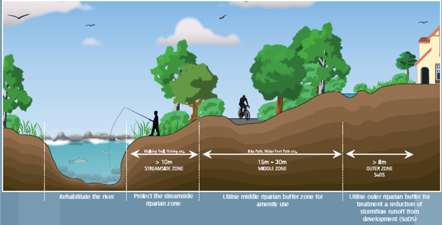
River corridors and their associated riparian zones are important for ecological and amenity reasons, flood risk management and water protection. Proposals for development along river corridors and in riparian zones shall have regard to the principles for protecting watercourses as set out in the document ‘Planning for Watercourses in the Urban Environment’ (Inland Fisheries Ireland, 2020 ) and any updated version of these Guidelines.
It will be necessary to set aside buffer zones with a sufficient area of land along the river corridor. The width of the riparian zone will be dependent on the width of the river and the nature of the site and as such it will be decided on a case by case basis. However, a minimum of 10 metres in width will be required. In some instances, buffers of up to 50 metres may be appropriate (as set out in the Guidelines). It is important that the buffer zone is large enough to protect the ecological integrity of the river and riparian zone (see Figure 11.1 for the suggested layout of a riparian buffer zone). Applicants are advised to refer to the above document and contact the Planning Authority at pre-planning stage with regard to buffers and the requirement for ecological assessment.
Figure 11-1 Indicative Layout of a Riparian Zone
A well-designed network of Green Infrastructure will help to:
- Provide high quality open spaces with associated health and social benefits for people through the provision of play areas, safe and attractive areas and routes for meeting, walking and cycling.
- Provide opportunities and space for contact with nature which is considered essential for good health and wellbeing.
- Allow communities to adapt to the impacts of climate change and flooding.
- Act as a natural water management infrastructure including drainage and flood attenuation, filtration and pollution control.
- Protect wildlife through the provision of buffer zones.
-
Incorporate nature-based solutions that contribute to the protection, restoration and enhancement of biodiversity and ecosystem services.
Green Infrastructure Objectives
It is the objective of the Council:
Objective GI01
- The integration of Sustainable Drainage Systems (SuDS) and nature-based solutions into the overall site concept and layout;
- The retention and enhancement of landscape connections such as trees, hedgerow and water features that provide habitats for species and allow movement between areas as much as possible. This is particularly important for development in rural areas and one-off housing. Such connectivity both within and to features outside the site should be demonstrated in the application. In the event that it is not possible to retain landscape connections, and in order to ensure that there is no net loss of biodiversity, proposals to mitigate and compensate/provide for new connectivity shall be detailed;
- To demonstrate, where applicable, the downstream impacts of significant landscape modifications and proposals to mitigate and compensate for same;
- To design the footprint of the development to avoid impacts on areas of high biodiversity value;
- Avoid building on flood plains. Incorporate these features into the design and use them as flood prevention and water management features;
- Ensure that adjacent designated sites are not impacted by the proposed development. This is particularly important for developments adjacent to wetlands;
- Landscaping plans shall use species appropriate to the physical and environmental conditions of the site including soil conditions, availability of space and aspect. These plans should use a high diversity of native trees, incorporating a variety of sizes and age classes to improve visual and structural diversity. New hedging and hedge reinforcement in rural areas must comprise native species. Landscaping plans must also incorporate the principles of the ‘Pollinator Friendly Planting Code – Professional Planting Recommendations’ of the All-Ireland Pollinator Plan 2015 – 2020 and any updated version of this code;
- Avoid culverting unless absolutely necessary and unavoidable;
- Creation of open drainage ditches instead of underground pipes where appropriate as these provide additional habitats and a water source for wetland species;
- Ensure that invasive species are not used in terrestrial or aquatic planting schemes; and
- Reduction of hard, impermeable surface to a minimum and to consider the use of green roofs.
Objective GI02
Objective GI03
Objective GI04
Objective GI05
Objective GI06
Objective GI07
To consider the appropriate reopening of existing culverts and infilling along watercourses to allow degraded watercourses to return to more naturally functioning systems, provide natural flood relief, provide for biodiversity gain and where appropriate, permit the recreational use of inaccessible riverbanks. This shall be done in consultation with the Office of Public Works and other key stakeholders such as Inland Fisheries Ireland, LAWPRO and National Parks and Wildlife Service and is subject to compliance with the Habitats Directive and normal planning and environmental criteria.
Objective GI08
To promote the appropriate retrofitting of streets and spaces in towns and villages with green infrastructure and nature-based SuDS solutions particularly in areas contributing to combined drainage systems.
Objective GI09
To promote the re-opening of existing culverts to daylight streams as part of a wider biodiversity restoration plan. This will require a multi-stakeholder approach including the OPW, Inland Fisheries, LAWPRO and NPWS. Consent, if necessary, should be obtained from the OPW to make these amendments of under the Arterial Drainage Scheme.
- 1- Mandatory objective 2(e) of Section 10 of the Planning and Development Act, 2000 (as amended).